Discussion – 

0

Discussion – 

0

Monday’s Severe Storm Risk Upgraded for parts of Texas

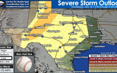
The early morning severe weather outlook from the Storm Prediction Center has the highest risk level across Texoma and North Texas between 3 PM and Midnight. Scattered severe storms are possible this evening into early Tuesday morning further south into Central Texas, the Hill Country, and the Brazos Valley and Northeast Texas. While all modes of severe weather are possible with the most intense storms, very large to giant hail larger than the size of a softball will be our primary concern.

The early morning severe weather outlook from the Storm Prediction Center has the highest risk level across Texoma and North Texas between 3 PM and Midnight. Scattered severe storms are possible this evening into early Tuesday morning further south into Central Texas, the Hill Country, and the Brazos Valley and Northeast Texas. While all modes of severe weather are possible with the most intense storms, very large to giant hail larger than the size of a softball will be our primary concern.

The potential for several intense supercell storms this afternoon and evening has increased in Texoma and North Texas – including the D/FW Metroplex. Scattered severe thunderstorms are possible in the Panhandle this afternoon, and this evening farther south into the Hill Country. The *most intense* storms may produce giant hail (4-5″) and damaging winds. The overall tornado risk is low, but not zero. The corridor most likely affected by a tornado issue is near the Red River around sunset. We’ll have a complete forecast posted by 6 AM in the free Texas Storm Chasers mobile app and weather blog. 

Simulated weather radar from the high resolution rapid refresh model showing scattered storms moving northeast across Texoma, North Texas, and Central Texas late this afternoon and this evening.

TSC App Users will need to tap the image to view the animation.

Advertisements

Initial thunderstorm development is expected around or after 3 PM in western North Texas, Texoma, and across Oklahoma. Storms will move quickly to the northeast, around 40 to 50 MPH. After 8 PM, a line of storms could develop further south across North Texas, the Hill Country, and Central Texas. Some storms may produce strong winds and large hail as they move east/northeast. Thunderstorm intensity should decrease early Tuesday morning as storms move into parts of the Brazos Valley and the Ark-La-Tex.

David Reimer

0 Comments

Submit a Comment

You May Also Like

Share to...