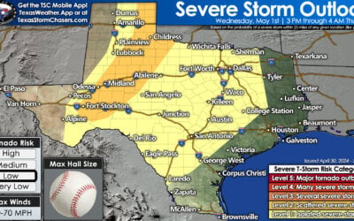
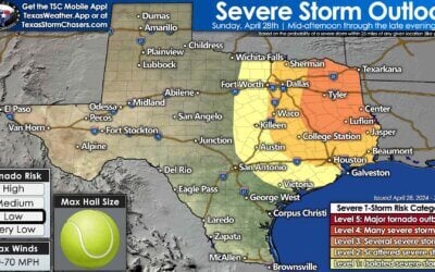
Parts of Texas will start April off with a literal bang—with the possibility of severe thunderstorms later today. At least isolated to scattered severe thunderstorms are possible after 3 PM across the Texas Panhandle, Northwest Texas, Texoma, and North Texas. The possibility of thunderstorms will increase after 8 PM further south into Central Texas, the Hill Country, and the western Brazos Valley. Storms may also move into the Ark-La-Tex and Northeast Texas this evening.
Severe Storm Threat Increases after 3 PM
Showers and thunderstorms are likely across the Texas Panhandle this afternoon and tonight. Some storms may be strong, with golfball-sized hail and gusty winds. As we get into Tuesday, rain may mix with or change to snow in the northern Texas Panhandle.
Today’s thunderstorm setup strongly favors very large to giant hail with the most intense supercells. Giant hail is defined as softball size, grapefruit size, or larger. That level of nasty-size hail is not guaranteed and certainly not expected with most storms today. Localized damaging wind gusts over 60 MPH, and a low tornado threat are also on the threat matrix board. The relative highest risk for severe storms with all modes of severe weather will be between 5 PM and 10 PM near the Red River south to Highway 380 in Texoma and North Texas.
A broken line of storms is expected to build south along a dryline/cool front after 8 PM in North Texas, Central Texas, and the Hill Country. Some of these storms may produce quarter to golf ball size hail along with localized damaging wind gusts. The line of storms will try pushing east into the Brazos Valley and Northeast Texas late tonight. Thunderstorm activity will weaken after midnight, though some storms may continue throwing out gusty winds and hail into the early morning hours on Tuesday. Isolated to scattered showers and storms will remain possible in the Ark-La-Tex, East Texas, and the Brazos Valley tomorrow morning.
We’ll monitor how today’s storm setup evolves throughout the morning and afternoon. Breaks in cloud cover east of the dryline could help destabilize the atmosphere more quickly, resulting in more storms or an earlier start. If the upper-level lift is weaker than expected or stays further north, we may see fewer storms south of the Red River. Regardless of the number of storms, conditions look to favor severe weather.
Today’s storms will be fast-moving to the northeast at 40 to 55 MPH. We’ll have live storm-chasing video by late afternoon in our free mobile app, on our website, and on the Texas Storm Chasers YouTube channel.
Texas’s Eclipse Weather Forecast
Rain chances will end in Texas by Tuesday afternoon. That’ll leave us dry until our next system arrives over the weekend. Unfortunately, trends for viewing the eclipse next Monday in Texas are poor. There’s only a ten to twenty percent chance of favorable viewing conditions. We have a sixty to ninety percent chance of heavy cloud cover and at least a forty percent chance of accumulating precipitation (rain) along the totality path in Texas. We’ll keep sharing information as we get closer, but these unfavorable trends have been pretty firm for the last several days in long-range data land.


Faith Miller
Alright…. Chicken , ostrich, Quail Egg size Hail ?
Good