
I would be remiss if I didn’t start without looking back to this day twelve years ago. On February 10, 2009, I witnessed the first tornado of my storm chasing career near Ringgold, Texas. I was looking north from Highway 82 as lightning amidst the setting sun illuminated a small cone funnel. That was the beginning of what became a long-track violent tornado in Love County, Oklahoma. Eight people died in Lone Grove on Highway 70 west of Ardmore. Twelve years later, we’re dealing with an upcoming arctic outbreak and multiple chances for winter precipitation in Texas. There will not be any violent tornadoes today, or severe thunderstorms for that matter.
Freezing Rain Today & Tonight
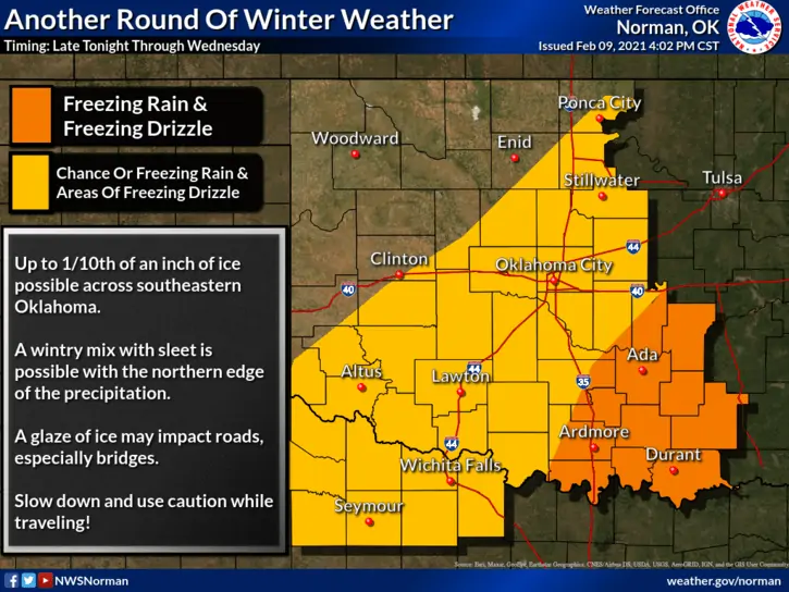
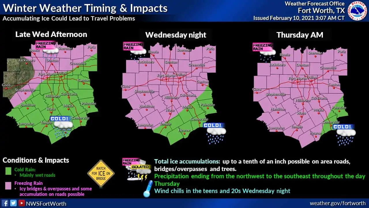
Freezing Fog is ongoing this morning across West Texas and the Texas Panhandle. Visibilities should improve this afternoon, but the cold weather certainly won’t. Freezing drizzle ongoing in the Big Country, Northwest Texas, and Texoma will continue through the day as temperatures struggle to climb above freezing. Those within the D/FW Metroplex may be able to rise a few degrees above freezing this afternoon. However, temperatures will fall again tonight as more showery-precipitation develops.
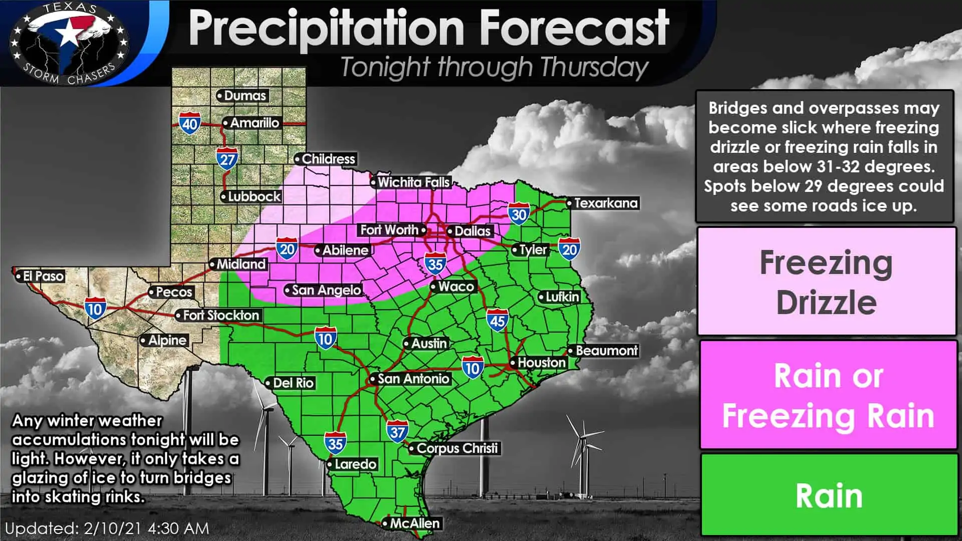
Showers will become more common this evening, overnight, and into the morning hours on Thursday. Where surface temperatures remain above 32 degrees will see cold rain. Rain will likely change over to freezing rain tonight as temperatures drop below freezing in the Concho Valley and portions of North Texas.
Temperatures ranging from 29 to 32 degrees will promote a glaze of ice on bridges, overpasses, and elevated surfaces. Surface temperatures below 29 degrees would result in some surface roads also glazing over.
Ice accumulations across the pink-shaded regions will likely only be a few hundredths of an inch, perhaps a tenth of an inch on some elevated surfaces. Not a big ice storm by any stretch of the imagination, but enough to cause travel headaches tonight and for the Thursday morning commute. The icy-bridge potential includes all of the D/FW Metroplex. A little ice can cause significant impacts.
Overall Rain Chances Tonight through Thursday Night
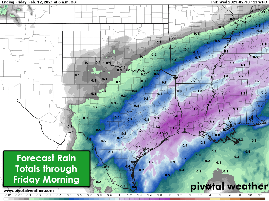
While I’ve focused on the system’s wintry-aspect, we will see a good soaker tonight and on Thursday across the southeastern half of Texas. Rainfall totals will range from one-quarter inch up to just under two inches. The highest rain totals should be in the Coastal Plains, Southeast Texas, the Golden Triangle, and in the Piney Woods of East Texas. Thanks to our recent dry spell, flooding is not anticipated. Friday should be a ‘down’ day in the precipitation department as one storm system departs. Another one begins approaching from the west.
The Arctic Outbreak Arrives This Weekend
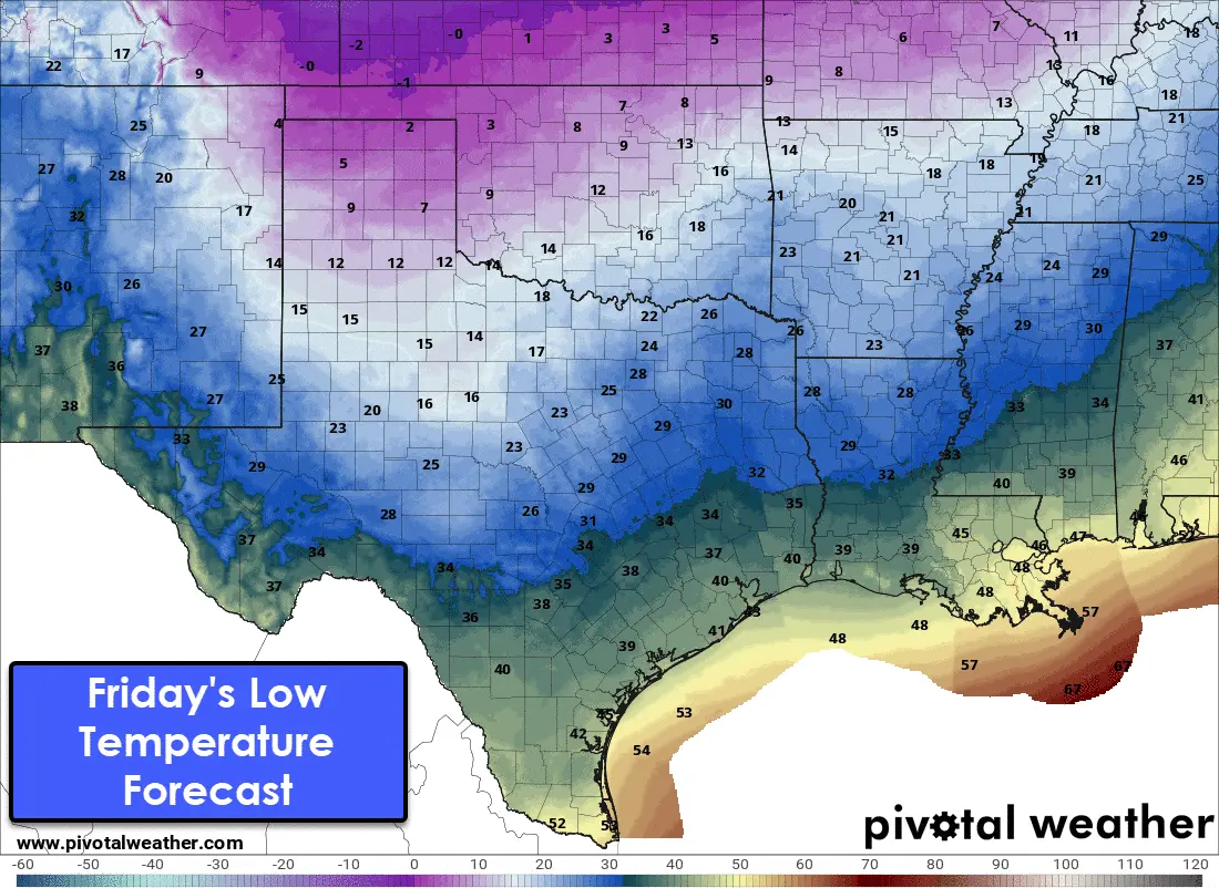
As precipitation concludes Thursday Night, we’re going to see an arctic airmass filter south into Texas. Some of us across the northern half of Texas has been cold for a few days now. It will become frigid – perhaps the coldest in the last few decades – across the northern half of Texas this weekend and early next week. Wind chill temperatures will be ten to twenty-five degrees below the actual air temperature. Wind chill values by Sunday and Monday mornings will likely be below zero north of Interstate 20. They could be closer to twenty-five degrees below zero across the Panhandle.
A word of caution with these temperature forecasts. Those who end up with a snow cover will likely have temperatures considerably colder than the forecast shows. In fact, we would be talking about some of the most frigid temperatures ever recorded for some cities. That is a good enough segway into our next topic – winter mischief!
A weak upper-level storm system will move across Texas on Saturday. The system looks pretty weak, but it may be able to squeeze out a few light snow showers across the northern two-thirds of Texas. Light rain is possible in South Texas and the Rio Grande Valley. At this time, no snow accumulations are expected, and the bitter cold will be the main issue this weekend.
Winter Storm Outlook for Sunday and Monday
Sunday and Monday are when things could become very, very interesting in the land of winter mischief. Please understand we’re talking about a potential winter storm several days away. It is difficult enough forecasting winter weather in Texas inside of twenty-four hours. We are not putting out specific accumulation numbers at this point – and anyone who is should probably not be amongst your ‘trusted weather sources’.
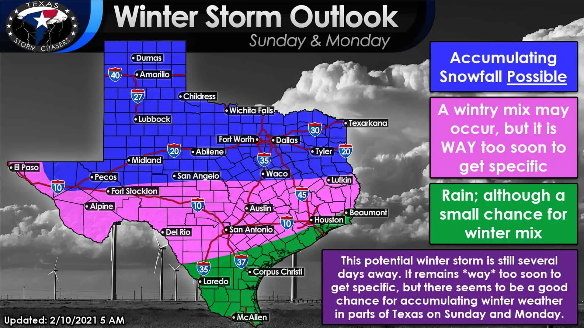
There is a solid signal in longer-range weather model guidance of accumulating snowfall on Sunday and Monday across Texas’s northern half. The event would begin on Sunday in the western third of Texas and spread east Sunday Night and on Monday.
Arctic air will already be in place so that the precipitation type would be a relative no-brainer for the northern half of Texas – snow. The southern half of Texas is where trying to determine a precipitation type would be more difficult. A winter mix certainly seems possible, perhaps into South Texas and Southeast Texas on Monday. A winter mix could include a trifecta of freezing rain, sleet, rain, or it could be just plain old rain.
Understand we are too far out to be able to tell you the exact ‘snow/winter mix/rain’ line. What I can say is it will be cold, wind chills will be obnoxiously cold, and there will likely be precipitation on Sunday and/or Monday in a large chunk of Texas. Snow and winter weather fans should keep their fingers crossed, as this does seem to be the ‘best chance’ of winter mischief on a large-scale that we’ve seen in quite a while.
Tuesday will likely still be cold, but we should start climbing up the temperature roller coaster. Temperatures may be much slower to rise next week in areas where snow cover is in place – and that ‘snow cover impact’ on temperatures could continue for several days.


0 Comments