
The chance of severe thunderstorms – capable of producing damaging hail, destructive winds, and perhaps tornadoes, along with an increasing flooding threat – will likely impact portions of Texas daily through at least Monday. Welcome to the prime time of our severe spring weather season. While we will be busy in parts of Texas, most of you won’t be dealing with it. Some of you may end up dealing with far more than you want. The weather forecast is unclear, and multiple ‘bust’ scenarios could prevent a higher-end severe weather threat today and Saturday.
Today and Tonight
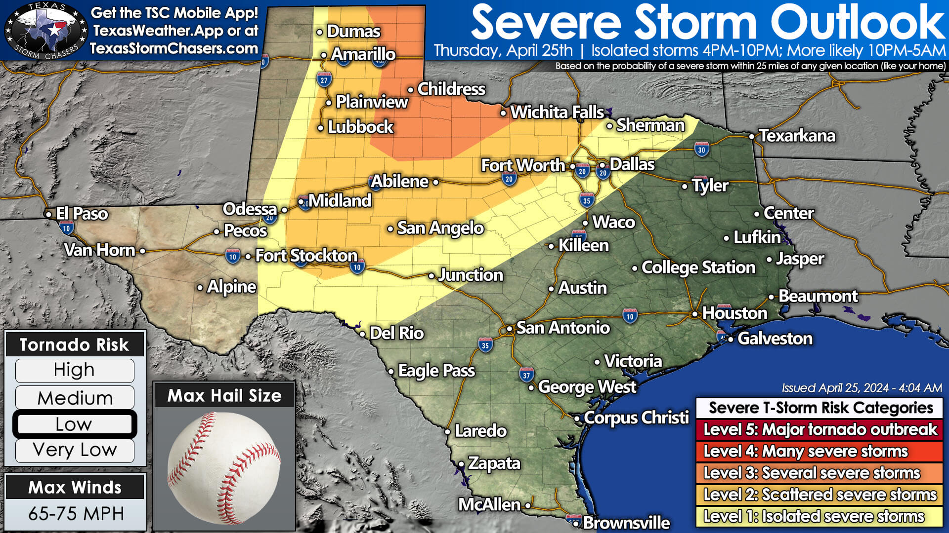
Isolated severe thunderstorms are possible after 4 PM across the eastern Texas Panhandle, West Texas, into the Permian Basin. A more substantial upper-level lift, likely needed to bust through the cap, will not arrive until tonight. Thus, storm development is questionable. If we can get rid of the clouds and warm closer to 90 degrees, we may be able to fire up a few storms. Any storms that develop have a high chance of becoming severe with destructive hail, damaging winds, and a tornado threat – especially in the Panhandle. Storms would move northeast at 30 to 45 MPH.
Severe Weather is More Likely Late Tonight into Pre-dawn Friday
Regardless of storm development this afternoon, we do anticipate issues tonight. As the primary upper-level lift arrives after 8 PM, perhaps closer to midnight, scattered severe thunderstorms will erupt across the eastern Panhandle, West Texas, into the east Permian Basin. A bi-modal storm mode is expected, with a squall line containing embedded supercells. Very large hail up to the size of baseballs, wind gusts up to 75 MPH, and embedded tornadoes are possible. This cluster of storms will move east/northeast into Northwest Texas, Texoma, and the Big Country early Friday morning.
Friday
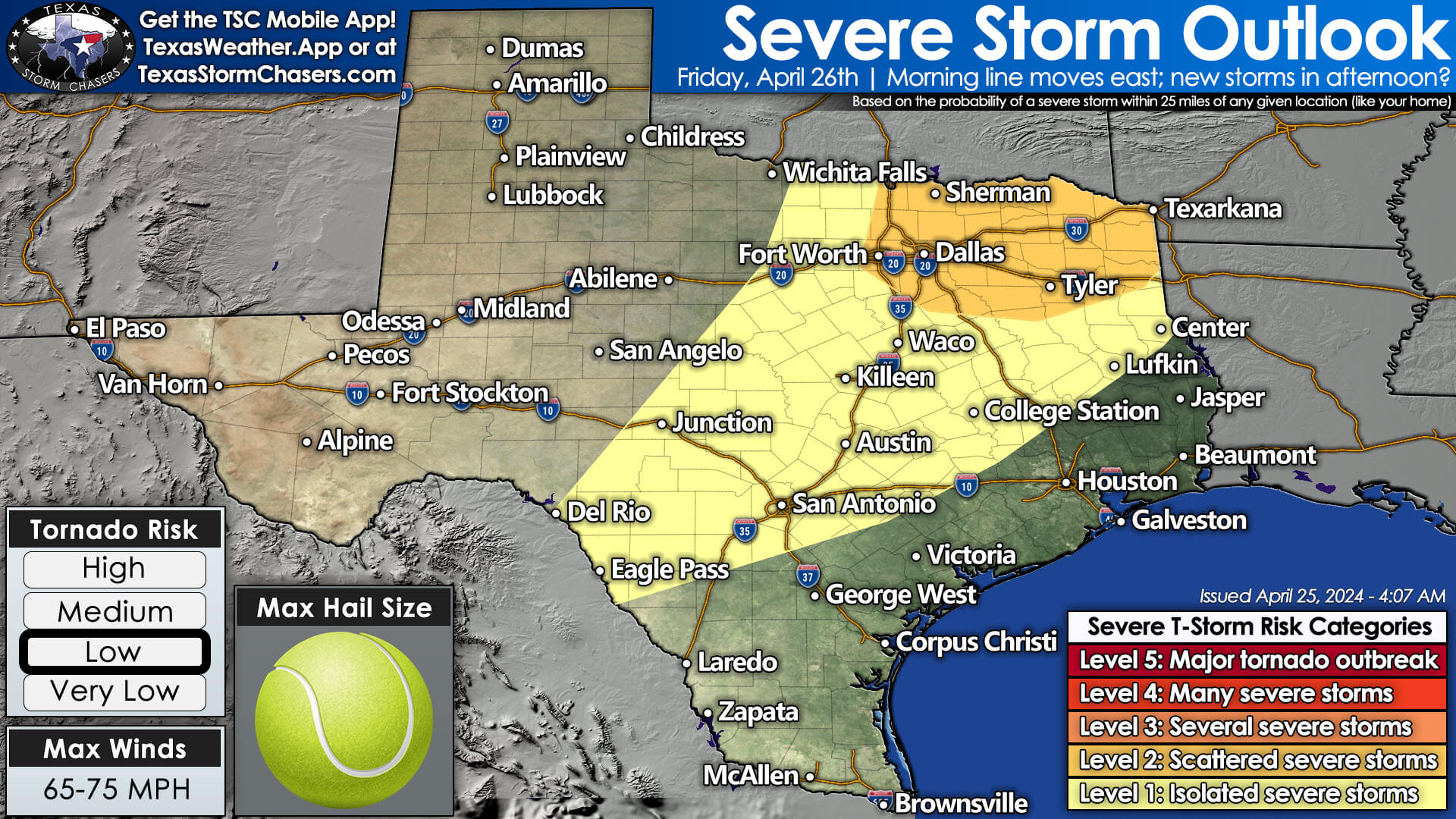
Depending on how far south storms develop tonight, we may see scattered storms move east into North Texas between 4 AM and 8 AM Friday with strong winds. We’ll carefully monitor trends this morning and afternoon to provide a better threat assessment for tonight and Friday morning. Some storms may remain severe throughout the night and past sunrise on Friday. If the line of storms does make it into North Texas tomorrow morning, they may re-intensify by late Friday morning into early Friday afternoon in Northeast Texas.
If tomorrow morning’s storms clear out of North and Central Texas promptly or don’t impact those regions, isolated to scattered severe storms are possible Friday afternoon and Friday evening. A superceulluar storm mode would likely have destructive hail, damaging winds, and a low tornado threat. The severe weather threat will decrease by late evening Friday. Scattered showers and storms, some with small hail, are possible across the eastern half of Texas late Friday into Saturday morning.
Severe Threat increases again on Saturday.
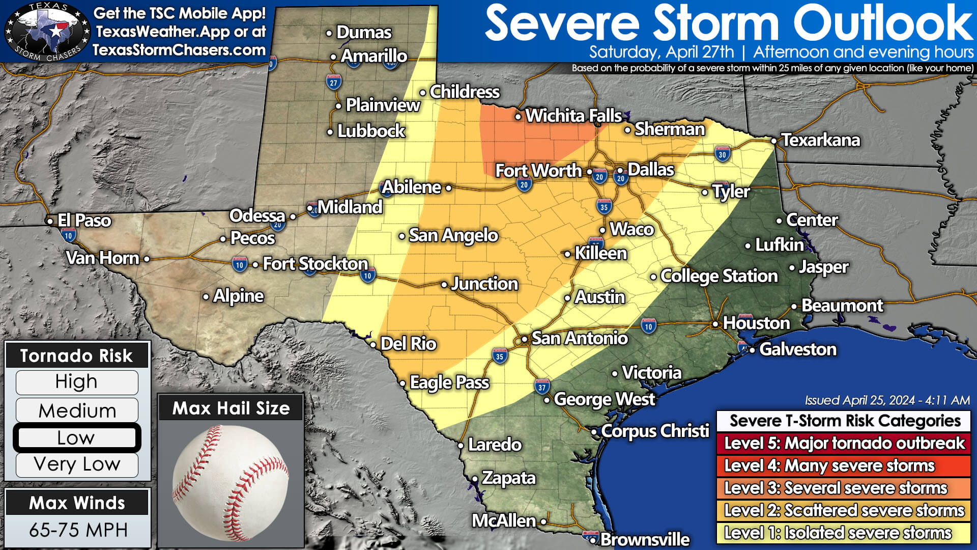
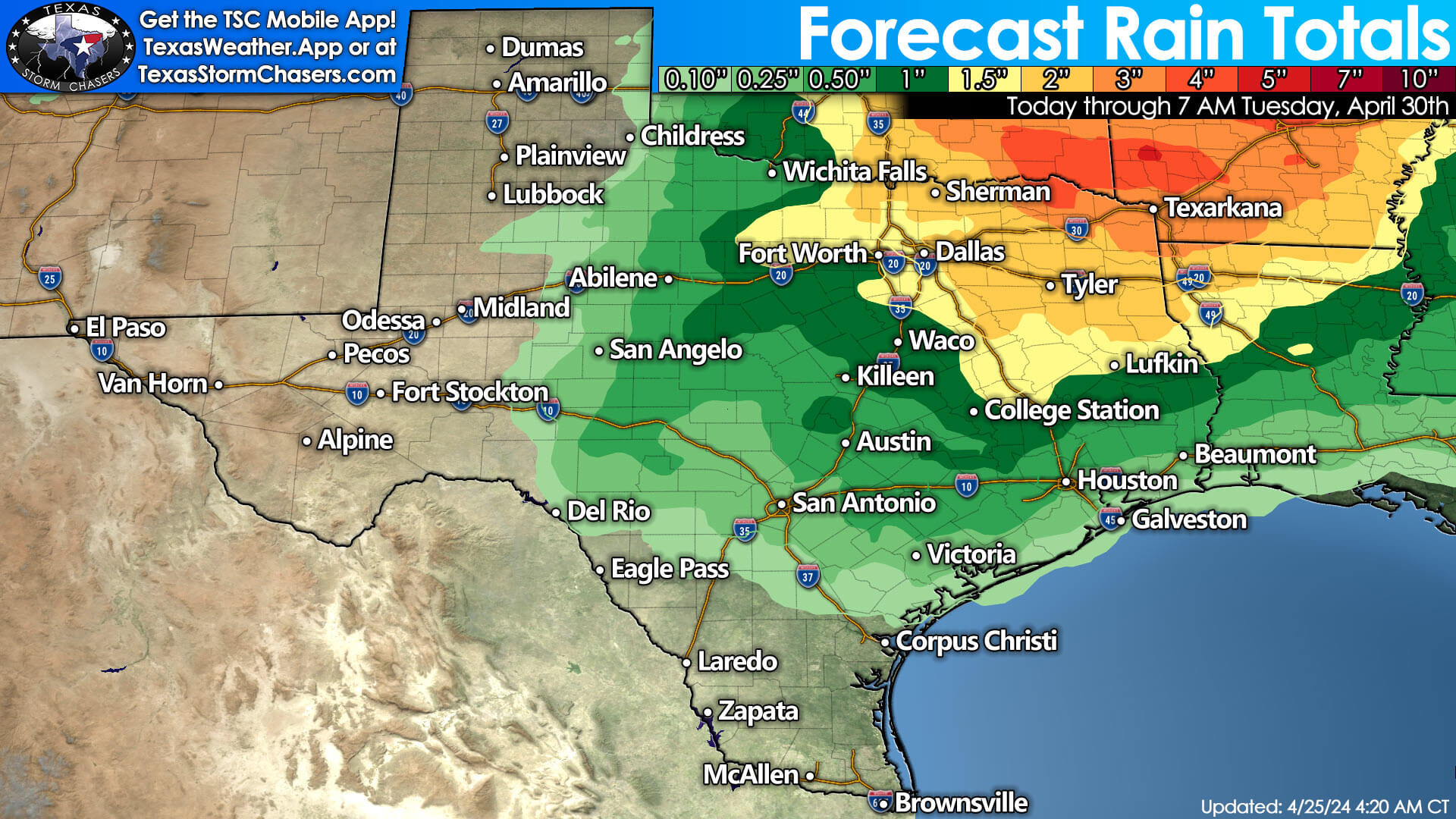
Scattered severe thunderstorms are a threat again Saturday afternoon into Saturday evening from the Edwards Plateau northeast through the Hill Country, Central Texas, North Texas, Texoma, and Big Country into Northwest Texas. Destructive hail, damaging winds, and some tornado threats all appear possible. As we continue into Saturday night, a cluster of thunderstorms will move across Oklahoma, extending south into Texoma – with the Threat of severe weather continuing. In addition to the severe thunderstorm risk, we’re becoming more concerned about flooding Saturday night and Sunday across Texoma, Northeast Texas, and East Texas. Heavy storms are expected on Sunday across North Texas, Northeast Texas, and East Texas.
It’s a never-ending story…
Guess what? We’ll probably see thunderstorms continue on Monday. Tuesday and Wednesday may be less active in the severe thunderstorm department as the Jetstream moves north, but late next week could bring a return to severe weather chances.
The cold fronts are in our future for the next five days. Expect seasonal temperatures across Texas.
Helpful Links
Check out our LIVE STREAM: https://texasweather.video/
Our FREE WEATHER APP: https://texasweather.app/
Our WEBSITE/RADAR: https://www.texasstormchasers.com/radar
Our SOCIAL PLATFORMS: https://linktr.ee/texasstormchasers
0 Comments