
A complex weather forecast is in store for Texas over the next week. We’re starting the short-term with an overachieving cold front moving south into Central Texas this morning. We’ll have another round of drizzle tonight with the added excitement of forecasting freezing drizzle. Precipitation chances increase Wednesday Night and Thursday Morning as a weak upper-level storm system moves across the state. Most precipitation will be liquid rain, but some winter weather is expected on the precipitation shield’s northwestern edge.
A reinforcing cold front will blast south into Texas on Saturday. A truly bitter cold air mass will push into Texas this weekend and early next week. There is an increasing threat for an extended duration cold air outbreak impacting all of Texas. This threat includes the freezing line pushing to the Rio Grande Valley Coast by Sunday morning – resulting in freezing temperatures and dangerously low wind chills for the entire state on Sunday and Monday.
Temperatures Today & Tomorrow
I mentioned yesterday that a cold front was expected to stall in northern sections of Texas today. Living up to its name, crashy the cold front has unsurprisingly (at least to those who have forecasted weather in Texas for a while) continued to push south overnight. Temperatures north of the front are thirty to forty degrees lower than immediately south of the cold front. The latest high-resolution weather model guidance suggests the front will continue pushing south this morning before stalling out this afternoon.
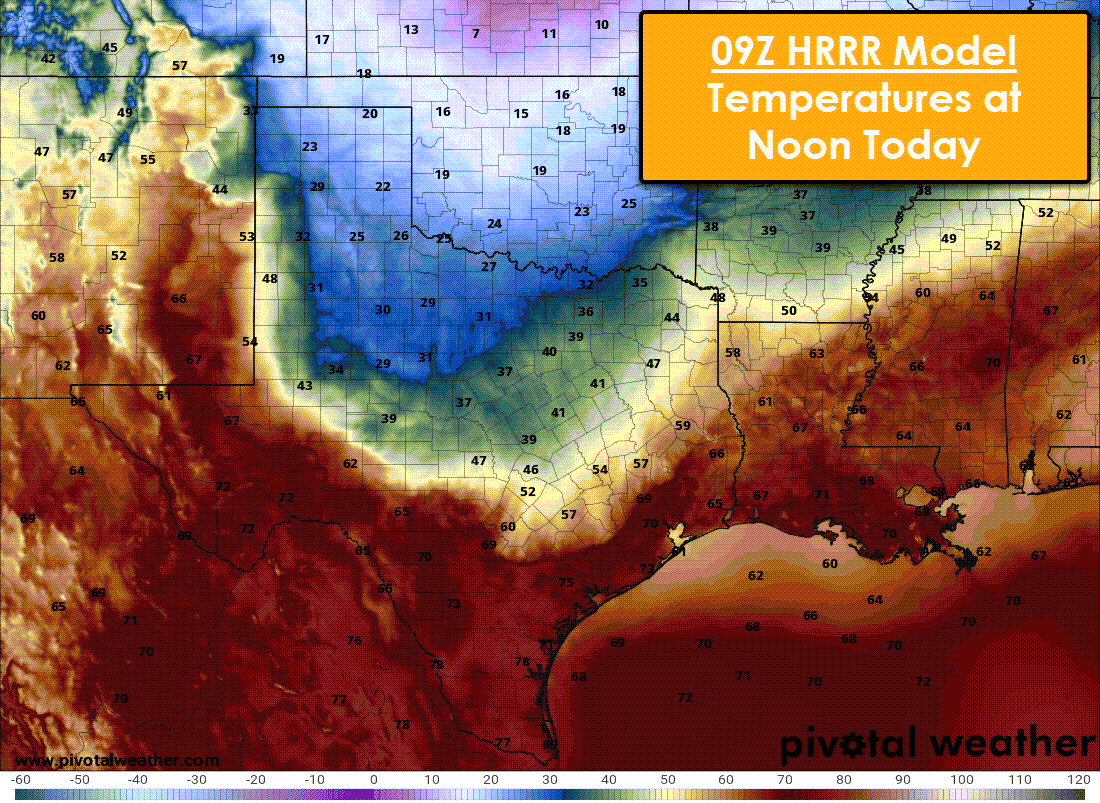
Forecast surface temperatures at 12 PM Today.
By noon the cold front should be just south of Midland to the north side of San Antonio to near Houston Intercontinental Airport. Temperatures in the 20s and 30s are expected across the Panhandle, West Texas, Northwest Texas, southward into the Big country. Temperatures in the cold air mass north of the front will struggle to climb more than a few degrees this afternoon. Of course, where the front arrives, temperatures will fall.
Wind chill values will be ten to fifteen degrees below the actual air temperature. Those south of the cold front, in the warm sector, will climb into the 60s, 70s, and 80s this afternoon. The cold front may not move all that much from this afternoon through Wednesday afternoon. However, dense cold air tends to sink farther south than weather models indicate. That happened yesterday and this morning, so don’t be surprised if it happens again today.
Warm air advection will try to shove the colder air out of the Permian Basin and West Texas tomorrow, but any warming will be short-lived. Temperatures may range over fifty degrees within a thirty-mile span, so that’ll be pretty neat to observe tomorrow. A reinforcing surge of cold air will start pushing the cold front south Wednesday Night and on Thursday – ending the warm weather for a vast majority of Texas.
Precipitation Chances Wednesday & Thursday
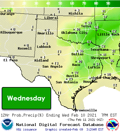
Chance of precipitation Wednesday through Thursday Night from the National Digital Forecast Database (NWS/NOAA)
Showers and thunderstorms will become more numerous on Wednesday and Thursday. Severe thunderstorms are not expected, and there may be a few heavier bursts of rain. Rain chances will end from north to south on Thursday and into Thursday Night. We’ll also see our reinforcing surge of colder air arrive.
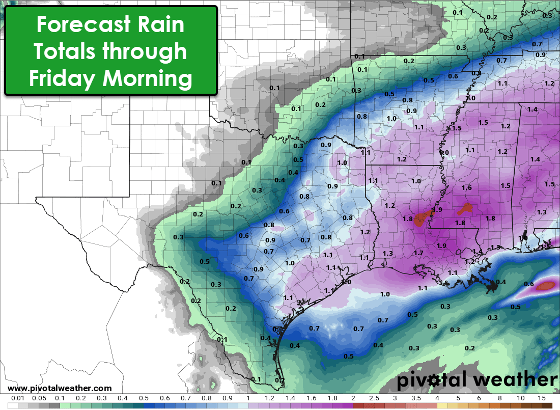
One-half to one inch of cold rain is expected across Texas’s eastern third with the Wednesday-Thursday precipitation event. Some folks might get lucky in East Texas and receive upwards of one and a half inches of rain. Again, severe storms are not expected, and flooding shouldn’t be an issue either. Yet, there is the freezing line’s pesky issue intersecting with the northwestern edge of precipitation tomorrow night and Thursday morning.
Freezing Rain & Ice Potential Tomorrow Night & Thursday
Surface temperatures below freezing combined with light freezing rain may result in minor ice accumulations Wednesday Night continuing into Thursday across Northwest Texas, the Big Country, Texoma, and portions of North Texas. The most significant potential for slick and hazardous road conditions will be where temperatures are below 29 degrees.
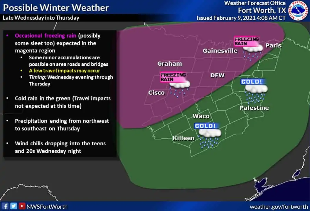
Temperatures of 29 to 32 degrees typically result in slick bridges, overpasses, and elevated roadways. The greatest threat for travel impacts will be west and north of the D/FW Metroplex tomorrow night. However, surface temperatures may fall below freezing in the D/FW Metroplex Thursday morning – and we’ll need to monitor trends carefully since there isn’t a lack of elevated ramps and bridges in D/FW.
The remainder of the precipitation will be rain as temperatures will remain above freezing in Central Texas, South Texas, and East Texas on Thursday. Temperatures are unlikely to climb much on Thursday (or until next week, for that matter). This is not expected to be a significant event in terms of accumulations. However, it only takes a small amount of ice on bridges to turn travel conditions into a nightmare.
Arctic Cold Front Arrives on Saturday
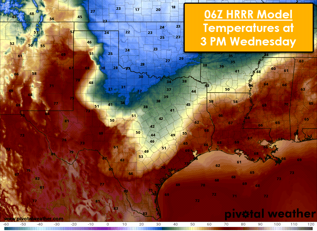
Seeing as my discussion is already competing for length-wise with a college commensuration, I’ll keep my weekend arctic front discussion short this morning. An extreme high pressure over the Central United States will allow bitterly cold air to flow south into Texas on Saturday through at least Monday. The four graphics above show surface temperatures at 6 PM for their respective days.
The graphics were produced by the National Blend of Models (NBM) – a relatively new yet useful product from the National Weather Service. The NBM ingests numerous weather models and blends them to produce a single output in addition to probabilistic forecasts. I’m using these graphics to provide a more uniform forecast. Still, please understand that the NBM may be too slow and too warm with this weekend’s cold front. Low temperatures will be nasty cold on Sunday and Monday, with wind chills in the ‘slap your mama’ bad category. (PS: Don’t go around slapping your mama. She’ll pummel you.)
I’ll be more detailed in future postings as we get a bit closer, but understand that this weekend’s cold snap will probably be the worst we’ve seen in several years, with the northern half of Texas remaining below freezing several days. Preparations to protect pipes, pets, plants, and folks who may not have heat should be completed by Friday Night.
Winter Weather Chances this Weekend and Early Next Week
A round of light snow may occur on Saturday across the Texas Panhandle, Northwest Texas, Texoma, and North Texas. If accumulations were to occur, they would likely be light. This potential still several days away and could quickly disappear into the land of weather model voodoo.
An upper-level storm system may produce precipitation across a large area of Texas on Monday while an arctic airmass is in place. This system remains well off in weather-model voodoo land. Still, various weather models and their ensembles do agree on the potential. That does not mean a major winter storm is expected across all of Texas. It is simply an indicator of a system we’ll be watching for in extended weather model guidance that is still six days away.
Finally, with very cold weather in place this weekend and early next week, we’ll need to be mindful that even light winter precipitation could cause issues with roadways. We’re typically borderline too warm for accumulations on roadways with our winter weather events.
You’ll be hearing a lot from us over the next week. Have a great Tuesday!


0 Comments