
After enjoying a quiet week of fall weather we’re going to be changing it up this week. Stepping out the door this morning you’ll notice moisture levels have rebounded upwards overnight. Dewpoint values have increased from the 40s and 50s up into the 50s and 60s. A reservoir of upper 60 degree dewpoints sits just off the South Texas coast. South winds will start to quickly bring that moisture inland this evening and tonight. Active weather is forecast this week with an upper level storm system sitting to our north. Several days of potential storm chances will begin tonight and continue through the end of the week. A strong cold front will surge south on Friday and Saturday – bringing an end to the humid/above-average temperatures.

Gone are the high temperatures in the 60s and 70s. This afternoon we’ll see temperatures soar into the middle and upper 80s with lower 90s a good bet too. With dewpoint values in the upper 50s to middle 60s it won’t be ridiculously humid, but it’ll be more noticeable than last week. Winds will become gusty out of the south west of Highway 281 this afternoon. Clouds will hang in tough across the Panhandle, West Texas, Permian Basin, and Borderland.


Isolated showers and storms will be possible by mid-afternoon in the Permian Basin, Alpine/Marfa areas, Borderland, into West Texas. Rain chances increase tonight across the Permian Basin, West Texas, and the Texas Panhandle.

Wind shear values will be supportive of a few organized thunderstorms tonight in the Texas Panhandle and West Texas. The atmosphere will be only marginally unstable tonight, but cooling mid-level temperatures may support a threat of hail with the stronger storms. Widespread severe weather is not expected tonight. The Storm Prediction Center has outlined a category 1 marginal risk to account for the hail risk tonight. We’ll see what data shows later this morning and if the risk area expands into Northwest Texas, the Big Country, and the Concho Valley.

By Tuesday a fall severe weather event will be taking shape from Northwest Texas into Oklahoma and Kansas. A strong upper level storm system will overspread strong winds aloft. Dewpoint values in the middle 60s will surge north ahead of a dryline. The dryline will move east from Central Kansas south into Western Oklahoma and Northwest Texas. The dryline will move east of the Texas Panhandle by mid-afternoon tomorrow – hence the risk of severe storms should remain east of the Panhandle.

The Storm Prediction Center has placed portions of Oklahoma and Kansas in an enhanced risk of severe weather for Tuesday. The standard category 2 risk runs north of a Hollis to Lawton, Oklahoma line. A category 1 risk includes the far eastern Texas Panhandle and Northwest Texas. The strongest storms in the category 2 and category 3 risk zones may produce hail up to the size of tennis-balls and wind gusts over 70 MPH. Isolated tornadoes will be possible but highly dependent on how much moisture is available along with the storm mode. Discrete supercells would have a higher risk of becoming tornadic. Storms that congeal into a squall line would have a lower tornadic threat, but a higher damaging wind potential.

The threat for severe weather in Texas on Tuesday is dependent on cap strength and the location of a developing area of low pressure. The current expectation is that the low pressure will remain far enough north to keep most of Texas capped. I would not be surprised to see one or two storms break the cap just east of the dryline late tomorrow afternoon. Any storm that develops could become severe with a threat of large hail, damaging winds, and a low-end tornado risk. Those severe weather threats are highly dependent on storms actually forming at all south of the Red River. If future data suggests storm development is more likely we’ll see the risk of severe weather increase. At this time the highest severe weather risk looks to remain north of the Red River where the cap will be weaker.
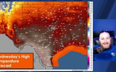
The dryline will move back west for Wednesday and lie somewhere in Northwest Texas southwest into the Permian Basin. This looks to be a day where the cap will win out – preventing thunderstorm development. A few storms may develop Wednesday night but would likely remain below severe limits. Storm chances will increase Thursday, Thursday Night, into Friday as a cold front moves south. A few storms may be strong. Any severe weather potential will be determined as we get closer to the late-week front.

Until the front arrives at the end of the week you can expect temperatures to remain near or above-average. High temperatures will be in the 80s and 90s with low temperatures in the 50s, 60s, and 70s. Overnight temperatures west of the dryline will tend to be cooler thanks to lower moisture levels.

0 Comments