
Scattered thunderstorm chances return to Texas over the coming days. With storms in May usually come big hail, strong winds, and enough lightning to make you bring out the sunglasses at night. While some will be dealing with nasty storms, some will be stuck with heat and humidity… until a cold front arrives by week’s end.
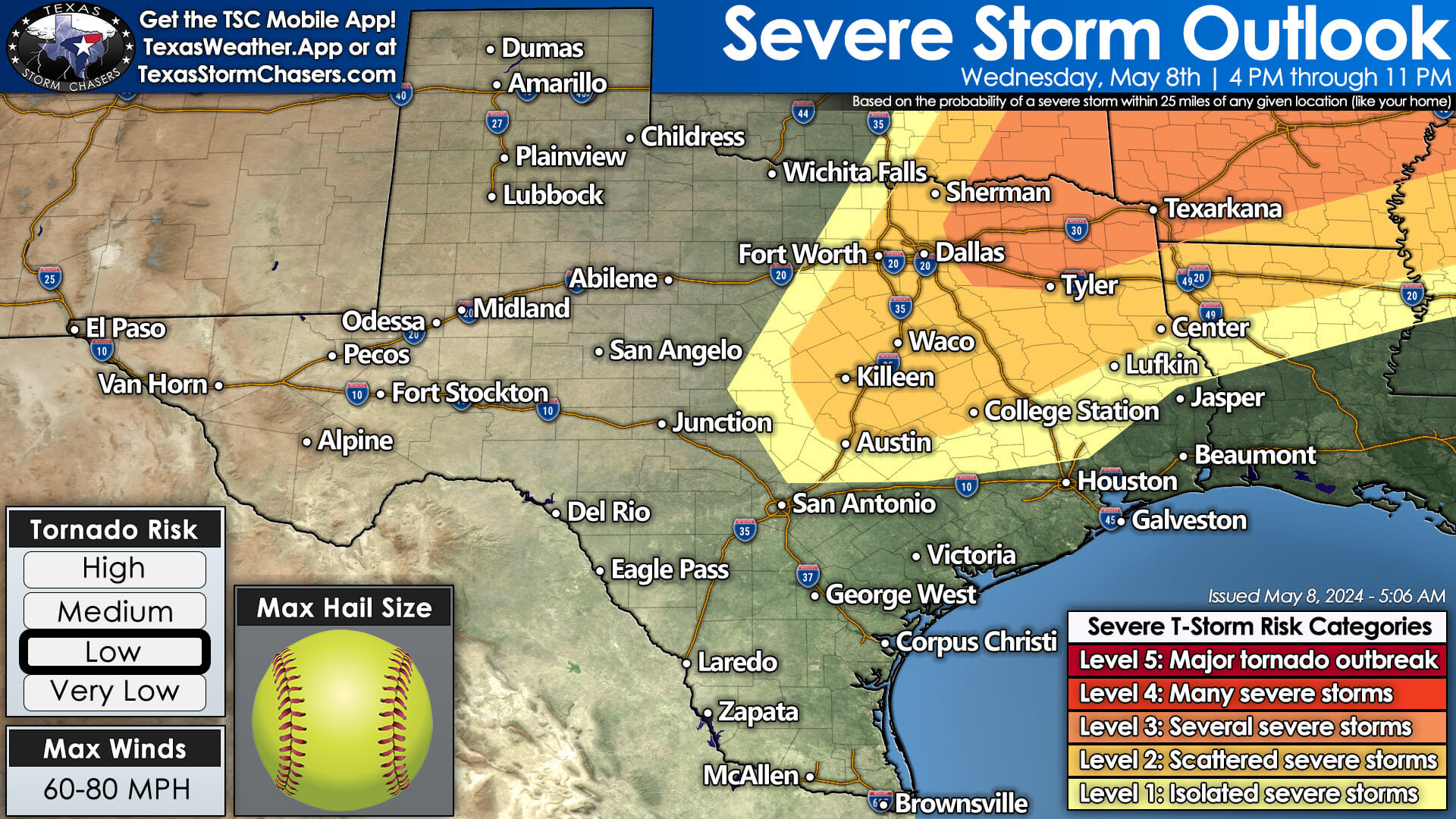
Scattered severe thunderstorms are possible late this afternoon through the mid-evening hours across Northeast Texas, North Texas, into parts of Central Texas and the Brazos Valley. These storms will likely form in proximity to a dryline/cold front that’ll be draped near the Red River. Extreme amounts of instability are forecast, along with modest wind shear, which will support supercell thunderstorms. Large to giant hail up to the size of grapefruits and softballs are possible with the most intense storms over the next few days. Localized damaging wind gusts and a low tornado threat are also hazards. Storms won’t be particularly fast-moving but should tend to move east/southeast. Overall storm coverage may remain more isolated today, but those under any storm could deal with large chunks of ice falling from the sky. Storm chances will decrease late this evening.
Storm Chances Continue Tomorrow

The cold front will slowly move south into Thursday. By the late afternoon, another round of scattered severe storms is expected to develop across North Texas into East Texas. Like today, the most intense storms will be supercells with giant hail and damaging wind potential. Storms may grow upscale into a cluster that moves toward Central Texas and the Brazos Valley Thursday night. While we don’t like using the ‘big city versus rural’ argument in our weather forecasts, the next two days could be one of those expensive hail events if we get an intense supercell over a highly populated corridor. Hopefully, we end up with nothing of the sort, and instead of hail-producing supercells, we end up with garden-variety showers. I can be optimistic, right?
Cold Front Brings Relief from Summer Preview
Friday looks to be docile in the thunderstorm department as the cold front continues to move south. Ahead of the front over the next few days, a summer preview will remind the southern two-thirds of Texas of why we dislike high humidity during the warmer months. What may be our last cold front of the spring for the southern half of Texas will bring a respite from the heat and humidity this weekend. High temperatures across Texas will drop into the 70s and 80s from Friday through Sunday. We’ll also lose some of that abhorrent tropical moisture.
Rainy Sunday
Rain chances will increase on Sunday across multiple regions of Texas. Some heavier rain potential is becoming evident across Central Texas, the Brazos Valley, and East Texas—with one to three inches possible. Given the ongoing heightened issues with flooding, there is some concern we may see a renewed issue. We’ll be mindful of the rainfall forecast as we get closer to Sunday. The good news is most folks will not see excessive rainfall, and severe thunderstorms are not likely this weekend.
Helpful Links
Check out our current LIVE STREAM: https://texasweather.video/
Our FREE WEATHER APP: https://texasweather.app/
Our WEBSITE RADAR: https://www.texasstormchasers.com/radar
Our SOCIAL PLATFORMS: https://linktr.ee/texasstormchasers

0 Comments