Today, there is a conditional risk for isolated severe storms in the eastern Panhandle and Texoma; however, there is a higher chance for storms with a cool front moving into Texas later this week. This brings a much-needed break from the widespread thunderstorm chances we’ve been experiencing over the last week and a half, offering relief.
Today will bring a conditional chance of a few severe storms to the eastern Texas Panhandle, Northwest Texas, and Texoma. A significant severe weather outbreak, including another dangerous episode of tornadoes, is expected north of the Red River in Oklahoma and Kansas this afternoon through Tuesday morning. A strong lid on the atmosphere, known as a capping inversion, looks to prevent many thunderstorms from developing east of the dryline in Texas.
Hopefully, that cap will prevent any storms at all. However, if we can break through the cap, any storms that develop will become intense quickly with destructive hail, damaging winds, and some tornado threat. The cap will be weaker north of the Red River, where a bad day is probable. Spotty showers and thunderstorms are possible in the eastern half of Texas this afternoon, but those aren’t expected to become rambunctious in the severe weather or heavy rainfall department.
Tuesday is likely to be a quiet day across most of the state regarding thunderstorms. Heat and humidity wise? Well, it will feel unpleasant across the state’s eastern half with air you can wear. Temperatures will also be climbing up into the uncomfortable territory.
Rowdy Storms Return Wednesday and Thursday… but with a Cool Front!
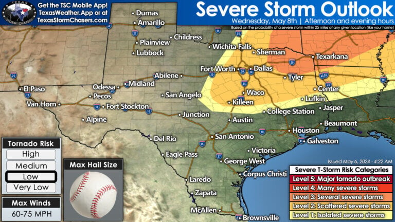
A cool front will begin moving south into Texas on Wednesday and Thursday. The chance for scattered severe thunderstorms will return to portions of the Concho Valley, Hill Country, Central Texas, North Texas, Texoma, Northeast Texas, East Texas, Brazos Valley, and Southeast Texas. The strongest storms will likely be capable of producing very large hail, damaging wind gusts, nutso amounts of lightning (a technical term for sure!), and locally heavy rainfall. It does not appear like we’ll see a repeat of last week’s prolific rainfall totals, so the threat of new, widespread flooding is lower. However, we will keep a vigilant eye on it since many rivers are running very high.
Our upcoming cool front will also knock temperatures back down to or even below May standards by Thursday and Friday, along with a significant drop in humidity values. Trust me, you’ll know what I mean by ‘air you can wear’ across the eastern half to the eastern two-thirds of Texas by mid-week.
Helpful Links
Check out our current LIVE STREAM: https://texasweather.video/
Our FREE WEATHER APP: https://texasweather.app/
Our WEBSITE/RADAR: https://www.texasstormchasers.com/radar
Our SOCIAL PLATFORMS: https://linktr.ee/texasstormchasers


How do you guys know if the cap is getting close to weakening verses being strong in full mode
Nicole Ashley NWS said last evening (Sunday) that the cap is weak.
Lamora Cole I figured I said the same thing over the weekend like it has to be getting weak because it’s been strong for so long. That’s the kind of days I worry about
Stetson MagilkeTy Magilke
This is so different than NWS Norman’s forecast.
Len E West this pic is for Wednesday
Robin Lile Wow 🌹🌹I love your post and what you share on here, You seem like a nice woman .I tried sending you a friends🥰 request but seems not going through. that’s why I decided to drop a comment here. If you don’t mind sending me a friend request let… See more
Robin Lile Wow 🌹🌹I love your post and what you share on here, You seem like a nice woman .I tried sending you a friends🥰 request but seems not going through. that’s why I decided to drop a comment here. If you don’t mind sending me a friend request let… See more
Becky Victorino
Amy Warren Wow 🌹🌹I love your post and what you share on here, You seem like a nice woman .I tried sending you a friends🥰 request but seems not going through. that’s why I decided to drop a comment here. If you don’t mind sending me a friend request let… See more
🙏
Will you be following the storms today?
So much for a calm week! I guess it is calmer than last week 😁
Can you explain why we/North Texas/metroplex always get “threats” of tornadoes and severe weather, but rarely ever end up happening because of the cap? Why is DFW always covered by a cap, and why does it almost never break?
Personal request for live coverage even though it’s mostly not going to be Texas
They updated the threat level for central Oklahoma to a 5, and moved the timeline up an hour.
🙏🙏🙏🙏🙏