
The Storm Prediction Center has issued a short-term technical weather discussion for East Texas. They indicate a tornado watch will likely need to be issued soon for the Ark-La-Tex, Northeast Texas, and portions of East Texas. Today’s severe weather setup favors a discrete storm mode and lower thunderstorm coverage.
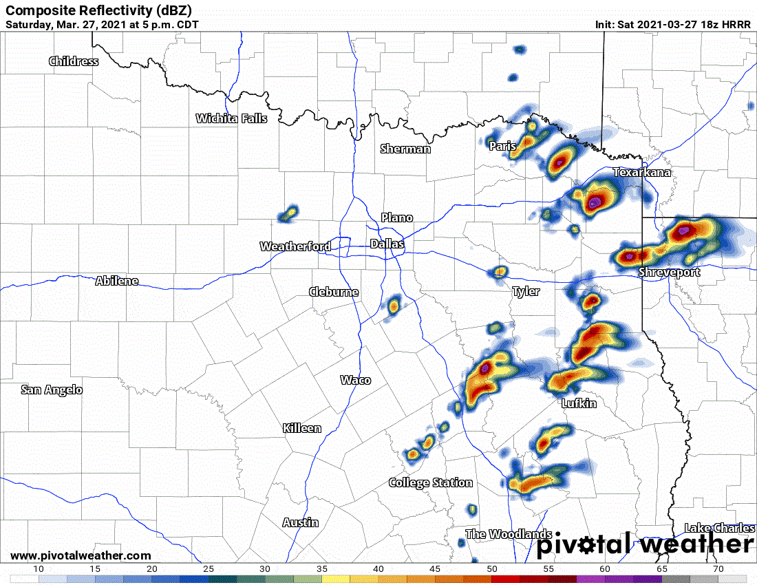
Simulated weather model radar from the 1 PM high resolution rapid refresh (HRRR) model for this evening.
Most folks won’t be impacted by thunderstorms this evening. Yet, the minority who do receive a thunderstorm has a higher chance of dealing with severe weather. The most intense thunderstorms are likely to be supercelluar with a risk of very large hail (up to the size of baseballs), localized damaging wind gusts, and even the potential for a tornado. I believe the highest risk of tornadoes will be just east of Texas, but we certainly can’t let our guard down. Isolated to scattered storms could be developing by 4 PM and continue through the mid-evening hours. Storms will generally move northeast, but a few may be ‘right-turners’ and move more east/northeast. We may also see a few stronger storms fire farther west closer to Interstate 35 around sunset.
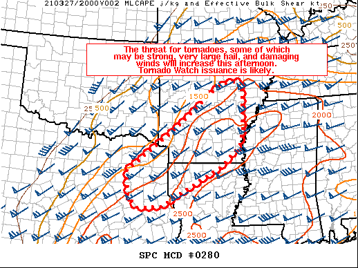
Mesoscale Discussion 0280
NWS Storm Prediction Center Norman OK
0216 PM CDT Sat Mar 27 2021
Areas affected…Portions of northeast TX…northern LA…and much
of southern/central/eastern AR
Concerning…Severe potential…Tornado Watch likely
Valid 271916Z – 272045Z
Probability of Watch Issuance…80 percent
SUMMARY…The threat for tornadoes, some of which may be strong,
very large hail, and damaging winds will increase this afternoon.
Tornado Watch issuance will likely be needed.
DISCUSSION…The airmass across the ArkLaTex region continues to
destabilize this afternoon, with surface temperatures generally
reaching into the 70s and low 80s at 19Z. Rich low-level moisture
already in place across this region combined with steep mid-level
lapse rates of 7-8 C/km are supporting MLCAPE of 1500-2000 J/kg.
Strong deep-layer shear of 50+ kt will easily favor discrete
supercells with initial development. Given a lack of obvious
large-scale forcing for ascent, the primary uncertainty is when
robust storms will form. Best estimate is that with continued
diurnal heating and weak low-level convergence along/south of the
warm front, storms will probably initiate by 20-21Z as a weak
low-level cap continues to gradually erode.
Large to very large (2+ inch) hail will likely be the main threat
with supercells initially, as low-level shear is not very strong at
the moment. But, a low-level south-southwesterly jet should
strengthen later this afternoon into the early evening, and tornado
potential with any discrete storms will increase. A strong tornado
appears possible given 150-200 m2/s2 of effective SRH by mid-evening
if storms can remain generally discrete. An increasing threat for
damaging winds may also eventually unfold later this evening as
upscale growth occurs. Based on towering cumulus becoming evident on
visible satellite imagery across AR, a Tornado Watch will likely
need to be issued.


0 Comments