Unsettled weather will bring a return of thunderstorm chances to parts of Texas over the next week, along with increasing wildfire danger and spring-time warmth. So, just what we expect in the weather department as we enter the final week of April.
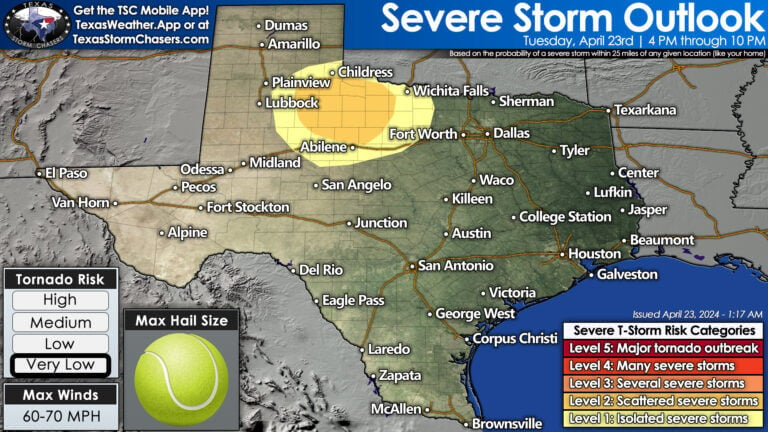
Today’s Severe Storm Risk
Isolated thunderstorms between 4 PM and 10 PM across Northwest Texas and the Big Country are possible. The number of thunderstorms will remain low. Any storms that get going will likely become severe, with a threat of large hail up to the size of tennis balls and localized damaging wind gusts. Thunderstorms will dissipate by late evening. Pockets of drizzle or light rain showers are possible across the eastern half of Texas during the morning hours on Wednesday. Significant precipitation is not anticipated.
A non-zero chance of a severe storm will exist late Wednesday afternoon and Wednesday evening in the Concho Valley, Big Country, and Northwest Texas. Storm chances are low, and it’s possible we may not have anything at all. If a storm develops, it will have hazards similar to those we expect today.
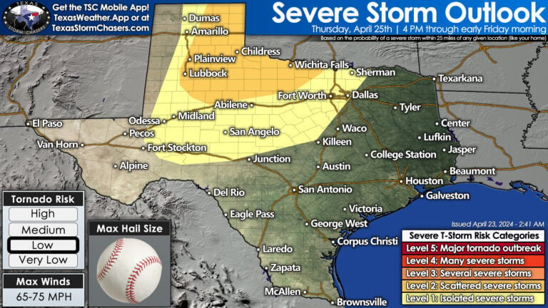
Thursday’s Severe Weather Potential
Thursday could be a day of heightened thunderstorm activity. Scattered severe thunderstorms are possible by late Thursday afternoon across the eastern half of the Panhandle and West Texas. These storms could potentially produce very large hail, damaging wind gusts, and even a tornado. A line of strong to severe thunderstorms will develop Thursday night in those same regions – moving east into Northwest Texas, the Big Country, and the Concho Valley with strong winds and hail.
Friday and Saturday
Showers and thunderstorms are forecast on Friday as the residual line of storms moves into Texoma, North Texas, Northeast Texas, and East Texas. The severe weather threat will be lower during the morning hours on Friday; though some storms may become strong again during the afternoon. Depending on how weather forecasts trend, some chance for rain may also exist in Central Texas and the Brazos Valley.
Severe thunderstorms become an increasingly likely hazard Saturday afternoon into Saturday night across Northwest Texas, the Big Country, North Texas, and Texoma. Depending on where the dryline sets up shop, this threat may expand further west. We’ll refine specifics as we get closer to the event, but for now – it has the makings of a busy day.
Cooler weather may arrive in the Texas Panhandle on Wednesday. Otherwise, we’re done with our crashy the cold front phase in Texas. Temperatures will remain warm and spring-like. A humid airmass will set up shop east of the dryline – typically the eastern half to the eastern two-thirds of Texas. Those west of the dryline will have increasing wildfire danger, especially by late week – along with very warm temperatures and periods of blowing dust.


When Is all the rain gonna stop. Too much. Lol
Faron Jennings not really too much, many lakes are over 11 ft low
Larry Stanford Medina is 86 feet below pool Travis is 56 feet low and buchanan is 26 feet down. send some rain down here!
You’re funny! Thanks for a solid weather forecast!
Fingers crossed! Love the rain.
Family just landed in Austin. 5 min ago from Florida. First time in Texas … how is the this week looking will be in Austin Houston, Dallas, Corpus Christi just a few of the places. Ty
Joan Bernard a few storms virtually each day especially north. South gets little to nothing
Thank you guys passed it on to them appreciate it 🦋
Kim Loucks thank you for doing that. 🦋
Joan Bernard http://www.weather.gov
Joan Bernard http://www.weather.gov
Ready for some more rain in West Texas. Our dry land needs it.