
The Storm Prediction Center has issued a short-term discussion for north Texas and southern Oklahoma. They’re planning on issuing a tornado watch in the coming hour. We just published a video update regarding tonight’s forecast (which I’ve included at the top of this post). Here’s the full SPC discussion…
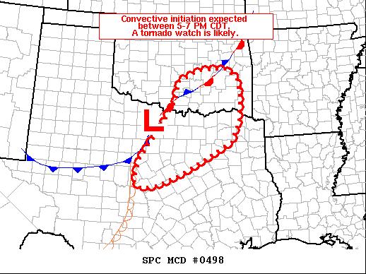
Summary: Strong to severe thunderstorms are expected to develop across north Texas and south-central Oklahoma between 5-7 PM CDT. These storms will pose a risk for large hail and a few tornadoes. A watch is likely by 21 UTC (4 PM CT).
Meteorological Analysis & Discussion: Surface observations from north TX and southern OK reveal a surface low northeast of Abilene, TX with a stalled cold front draped to the southwest and a dryline extending to the south. To the northeast of this low, a stationary front is noted across southern to northeast OK. Recent GOES visible imagery shows a shallow, but growing, cumulus field west of the DFW metro into southeast OK east of the stationary boundary.
A 19 UTC FWD sounding shows considerable MLCIN remains in place, and should keep convection at bay in the near term. However, continued diurnal heating and increasing ascent over the region (due to the approach of an upper-level wave from the west) will help erode lingering inhibition by the 5-7 PM CDT time frame.
Deep-layer shear is forecast to increase as stronger flow associated with the synoptic trough moves over the region, which will support initially discrete cells along the dryline and stationary boundary. Steep mid-level lapse rates noted in the 19 UTC FWD sounding and dewpoints increasing into the upper 60s/low 70s will support MLCAPE values near 3000-4000 J/kg.
Consequently, severe hail appears likely and a few instances of large (2+”) hail are probable with any initial discrete storms. The KFWS VWP recently observed around 100 m2/s2 0-1 km SRH, which may support at least a low-end tornado threat across north TX.
The tornado threat will likely be higher along the Red River and northward into south/southeast OK in the vicinity of the triple point and along the stationary boundary where more backed low-level winds are noted and environmental vertical vorticity is higher.
Although the potential for a few tornadoes exists with any initial discrete convection, rapid upscale growth is possible within an hour or two after initiation, and may limit the overall tornado potential. Nonetheless, a tornado watch is likely by 21 UTC.


0 Comments