
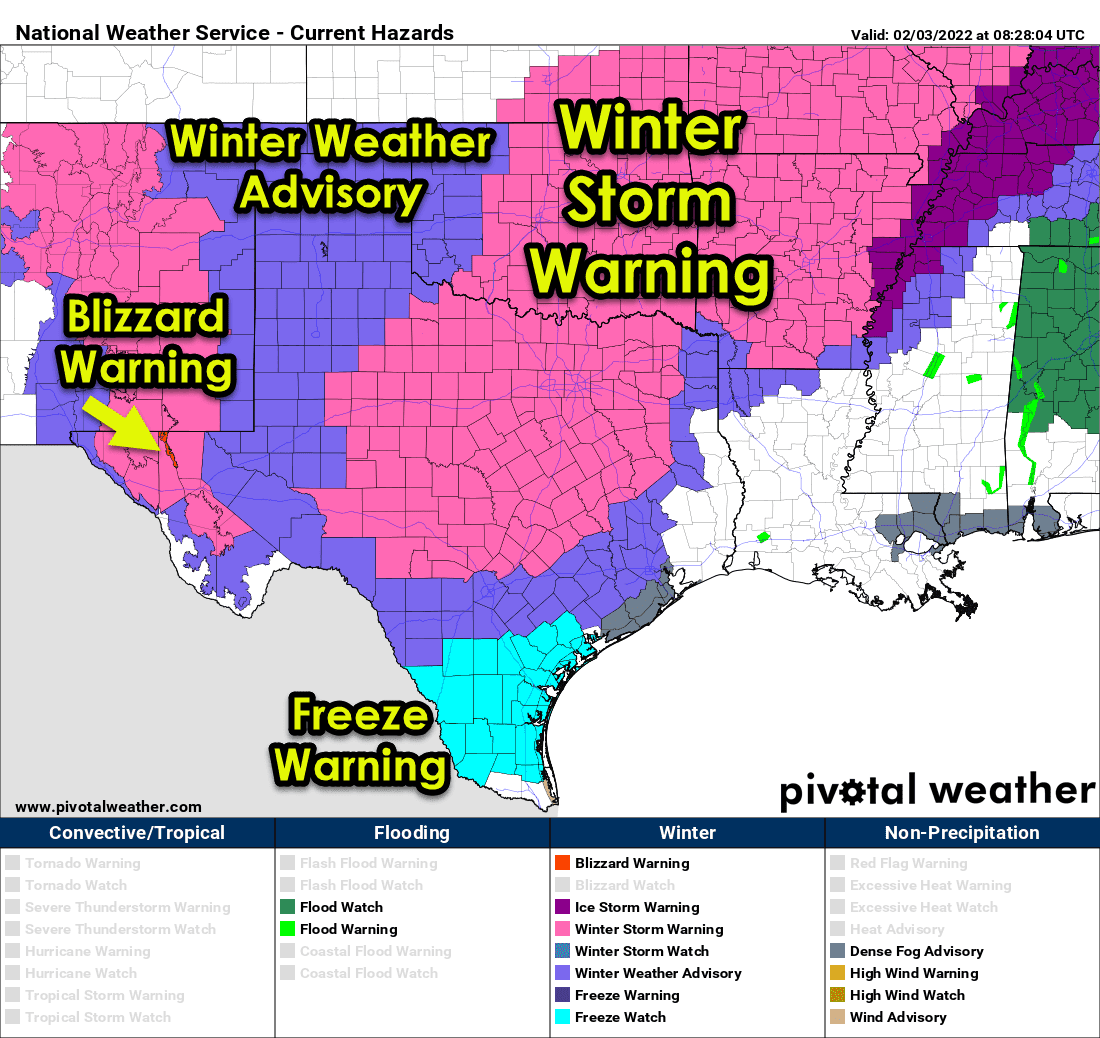
The freezing line continues to march east and south early this morning. Rain has changed over to a winter mix west and north of a line from Paris to Terrell to Waco to Round Rock to Boerne to Leakey to the north of Del Rio. We anticipate freezing rain to begin in Waco, Temple, Round Rock, Georgetown, Austin, and Austin by 4:30 AM, as temperatures are now at freezing. Freezing rain and Sleet continue across Texoma, North Texas, the Hill Country, and the Concho Valley.
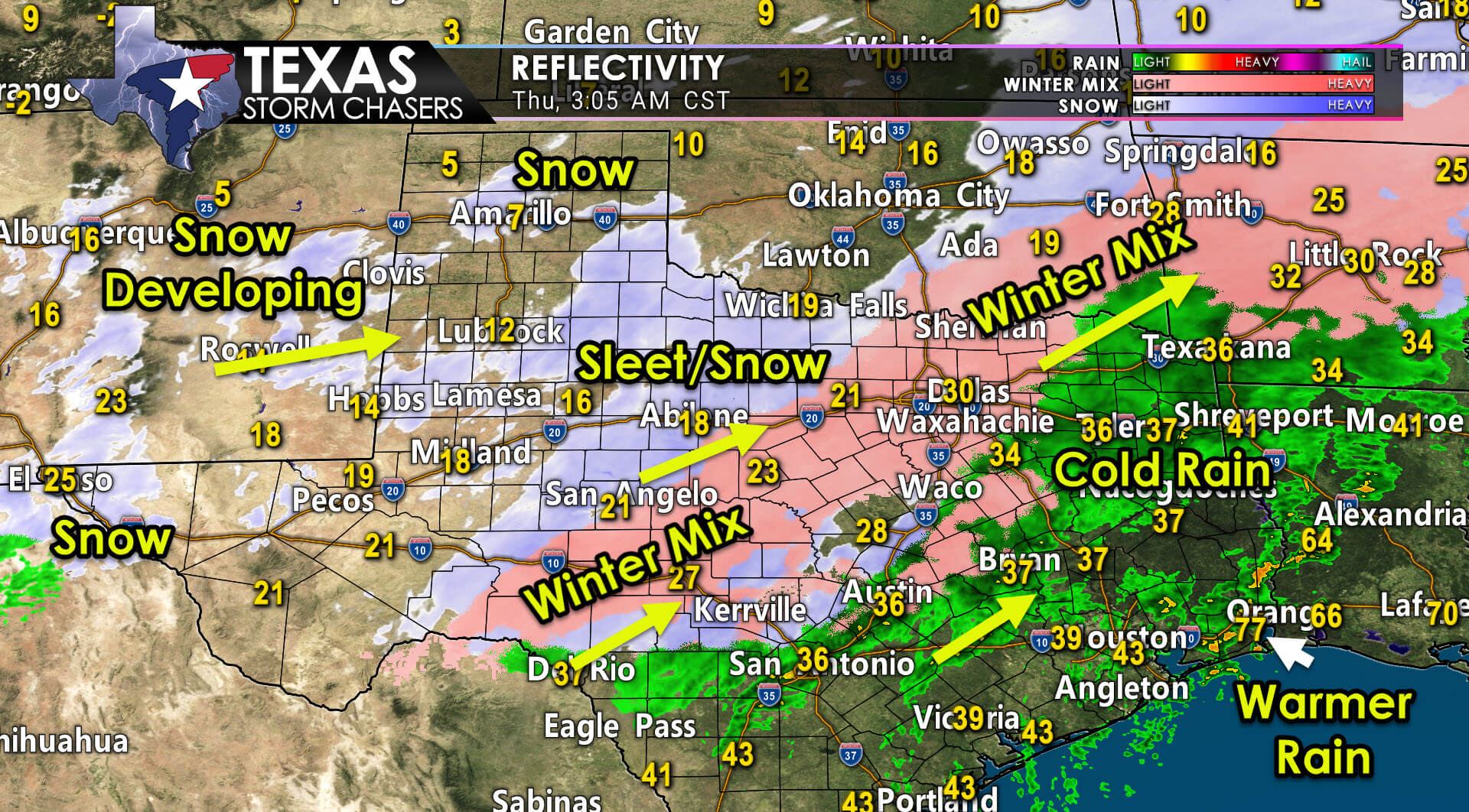
A sleet/snow mix is ongoing across the Big Country. We’re seeing new snow bands develop across Northwest Texas, West Texas, and the Texas Panhandle. These new snow bands are being produced by another piece of upper-level lift arriving from the west. Snow also continues early this morning in the Borderland (El Paso).
Accumulating winter precipitation will continue for several more hours across Texoma, North Texas, the Hill Country, Northwest Texas, and the Concho Valley. Rain changing over to freezing rain is expected soon in Central Texas and within a few hours across the Brazos Valley.
Freezing rain poses the highest threat of causing downed trees and power outages. While certainly making roads a mess, Sleet and snow will not ‘sag’ the trees and powerlines. I’m hopeful any ongoing freezing rain across the D/FW Metroplex will change over to Sleet and snow by 5 AM. This morning, freezing rain will likely create a similar mess across the Hill Country and portions of Central Texas.
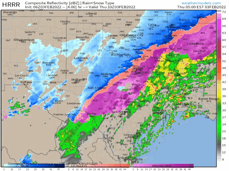
Winter precipitation will continue through the mid-morning hours across Texoma, North Texas, Central Texas, and the Hill Country. We’ll also see light to moderate snow through this afternoon across the Texas Panhandle and in Southwest Texas (I-10/I-20 split down into the Davis Mountains). Precipitation intensity and coverage will be decreasing across the eastern half of Texas by mid-afternoon as our upper-level storm system starts departing.
As temperatures across the Coastal Plains and portions of Southeast Texas, including the Houston metro, flirt with freezing later today, we may see light freezing rain occur. Icing impacts could develop on bridges and overpasses if we do see freezing rain materialize.
Temperatures will not climb much today across the northern two-thirds of Texas. Folks that are below freezing will likely stay that way through Friday afternoon. Hard freezes are expected Friday morning and Saturday morning, where snow and ice cover are present. It is worth noting that any moisture on roads across the northern two-thirds of Texas that hasn’t frozen today will likely flash-freeze – creating black ice. We’ll also have to deal with nightly ‘black ice’ tomorrow and through the weekend. Whatever melts and doesn’t evaporate during the daytime hours will ‘refreeze’ into ice as temperatures drop below freezing.


0 Comments