
The freezing line, where surface temperatures are at or below 32 degrees Fahrenheit, extends from San Antonio to Giddings to Athens to Mineola to Clarksville. The D/FW Metroplex has temperatures in the lower to middle 20s. Waco, south to Round Rock, are in the upper 20s. Austin down to San Antonio are right at or below freezing. Temperatures will continue falling through the morning. We do not expect much of a diurnal temperature swing today. It’ll be a cold, windy, and downright nasty day behind crashy the arctic cold front. That’s right! It isn’t just a regular ‘crashy the cold front’; it is a polar special. Crashy the cold front is not an official term, but I tend to give random things nicknames – a #BaldyInChief specialty!
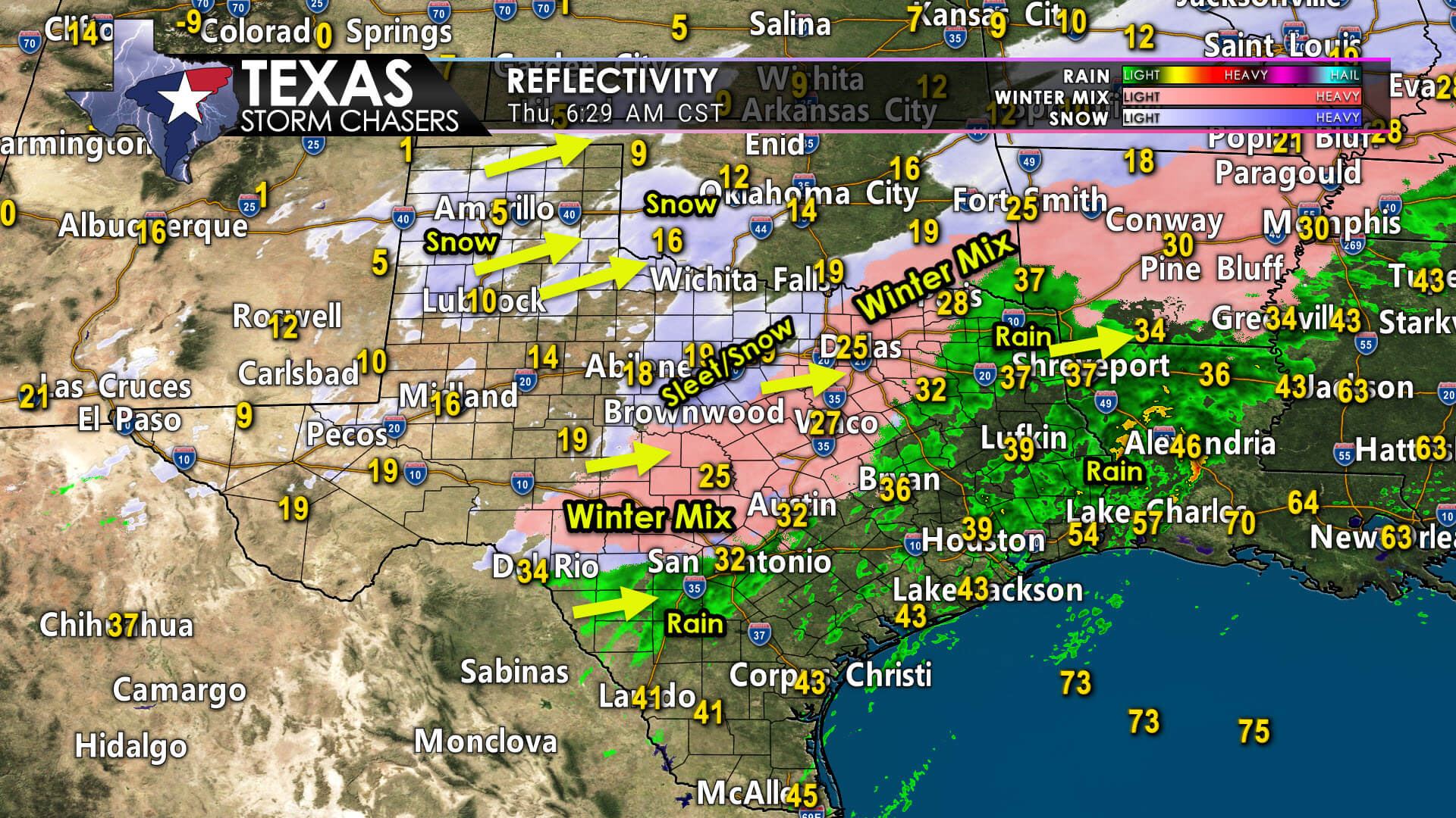
Freezing rain mixed with sleet continues across the northern Edwards Plateau, Hill Country, eastern Concho Valley, Central Texas, and North Texas. Sleet, mixing with snow, continues in the Big Country and the western Concho Valley. Additional snow is moving northeast across West Texas, the Texas Panhandle, and far Northwest Texas – where temperatures are in the single digits with wind chills well below zero. Showers and thunderstorms continue across East Texas, Southeast Texas, the Golden Triangle, and South-Central Texas. The freezing line will continue moving southeast today, although it’ll progress more slowly during the daytime hours.
Snow is coming to an end in the Borderland (El Paso). Precipitation ongoing across the Big Country and Concho Valley will continue moving east this morning. A few light snow showers will remain possible through the afternoon in those regions. We’re expecting snow to move east of Interstate 35 in Texoma and North Texas around lunchtime. Precipitation across Central Texas will move east into the Brazos Valley this afternoon – where a winter mix will continue.
Significant ice accumulations are possible – enough to cause tree damage and power outages. If we can switch over to sleet, that’ll reduce the stress on trees and powerlines. Regardless of the winter precipitation type, road conditions are going to be poor.
As the freezing line moves southeast this afternoon, the chance for a winter mix could inch into the Houston Metro and Coastal Plains. Road conditions, especially bridges and overpasses, could be problematic if that changeover occurs during the evening rush hour.
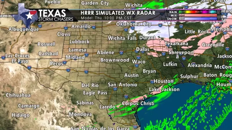
Another upper-level storm system will bring snow to the Texas Panhandle this morning. Most of that activity will move northeast into Oklahoma this afternoon. An additional one to four inches of snow may fall in the Panhandle this morning. There may be enough lift on the southern edge of the storm system to generate light snow showers (or freezing drizzle) in Texoma, North Texas, and Northeast Texas late this afternoon and tonight. Accumulations from that winter garbage wouldn’t compare to this morning’s event, but it would add a little icing on top of the symbolic cake’. We’ll keep tabs on the possibility today.
Frigid Airmass Settles In Tonight
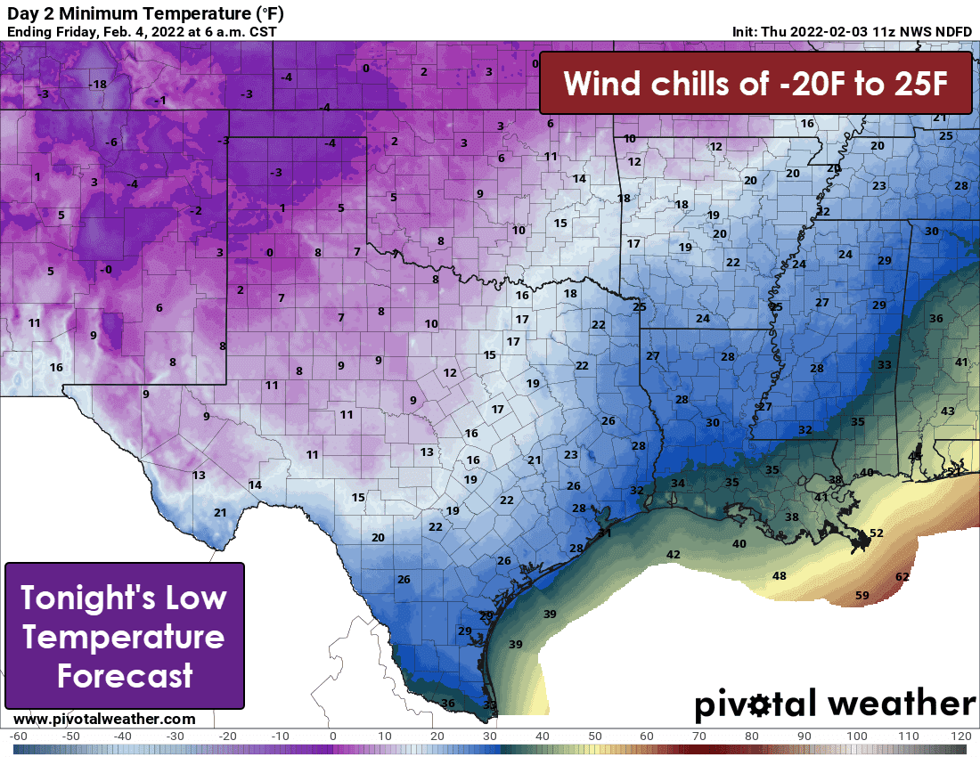
Temperatures will not climb much today across Texas. Those who are ‘warm’ will drop faster than the stock market once the cold front arrives at your location today. Temperatures tonight will drop below zero across the Texas Panhandle. Single-digit low temperatures are expected as far south as the Trans-Pecos, Permian Basin, Big Country, and western North Texas. Teens are likely into the Edwards Plateau, South-CEntral Texas, and the Brazos Valley. Pretty much the entire state will drop below freezing tonight and again Saturday morning. Tonight, wind chill temperatures will range from twenty below in the Panhandle to the middle twenties in the Rio Grande Valley.
Warmup begins tomorrow; but it’ll be slower for snowpacked regions
Most of Texas will rise above freezing Friday afternoon. An exception will be where there is significant snow or ice accumulations. All of that winter cover will keep temperatures below freezing tomorrow. Saturday looks warmer, so hopefully, all of the states will rise above freezing on Saturday. However, overnight low temperatures through early next week will drop below freezing. During the day, any melting of snow or ice will refreeze into black ice at night – something that could be problematic for several upcoming nights.


0 Comments