
Seasonal and reasonably quiet weather will continue tonight and for most of tomorrow. We’re blessed that our spring severe weather season has yet to kick into gear versus last year in West Texas. Severe thunderstorms are not anticipated in Texas over the coming five days. What we are expecting, beginning tomorrow, is a strong cold front and a good chance for a freeze by Saturday morning for the northern two-thirds of Texas.
Temperature Forecasts
Thursday is looking to be seasonably warm, with high temperatures topping out in the 70s and 80s for most of Texas. That warmth will be replaced by gusty north winds and much cooler air tomorrow evening into Friday as a strong cold front arrives from the north.
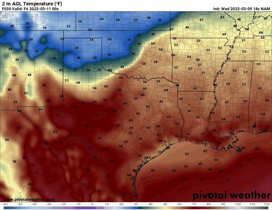
North American Model (NAM) temperatures for late tomorrow through Friday. Times are in Zulu/UTC. 00Z is 6 PM CST, 12Z is 6 AM CST.
Crashy, the cold front should arrive in the Texas Panhandle tomorrow morning. Temperatures are likely to be quite cold, with wind chills in the teens. Everyone else in Texas will enjoy the spring-like warmth. The cold front will accelerate south/southeast tomorrow night and into Friday. We believe the cold front will arrive in the D/FW Metroplex west to Midland around midnight Friday. Temperatures behind the cold front will be about twenty to thirty degrees lower.
Friday will start warm across the southeastern half of Texas. As the cold front continues to move southeast during the day, we’ll see temperatures drop significantly – so high temperatures will occur during the morning hours for some folks. By dinner-time Friday, the only folks still enjoying ‘spring’ will be the Rio Grande Valley and perhaps the Golden Triangle. It’ll be chilly elsewhere, with temperatures in the 30s and 40s.
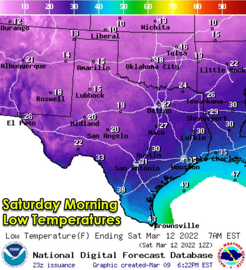
Saturday morning is lining up to feature a freeze for the northern two-thirds of Texas. Radiational cooling will play a significant role, so sharp temperature gradients over short distances due to terrain and urban heat islands are expected. Folks with sensitive outdoor plants would be wise to take precautions, especially if you’re not in South Texas, the Rio Grande Valley, or the immediate Texas coast.
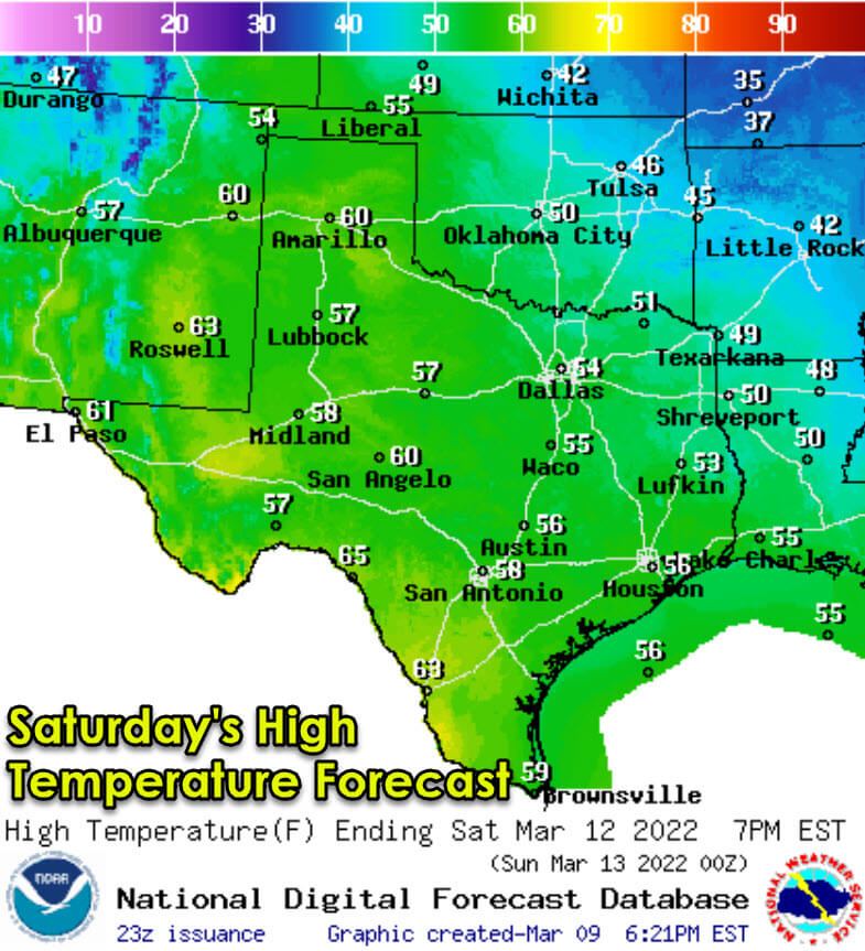
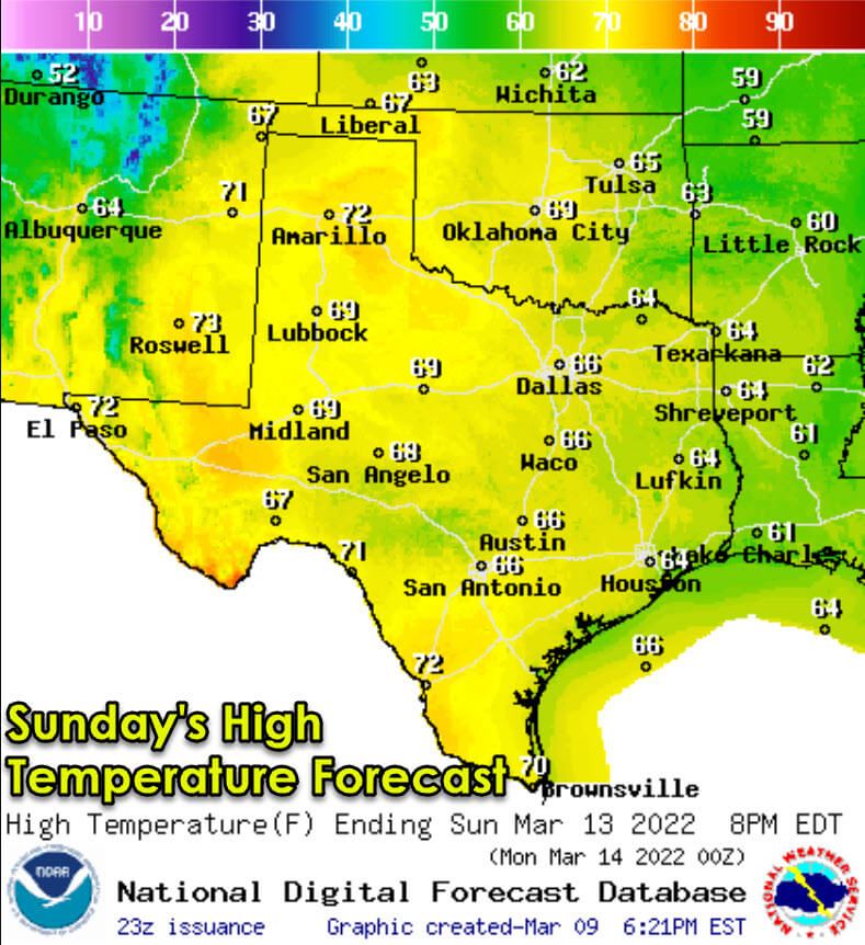
Perhaps more impressive than the cold front will be the rapid warm-up this weekend. High temperatures on Saturday will top out in the 50s and 60s across all of Texas. Sunday will be even warmer with a plethora of 70+ degree temperatures across the eastern two-thirds of Texas. There is a concern for a fire-weather event on Sunday as low humidity combines with gusty winds and warm temperatures.
Winter Mix & Snow Potential
A round of accumulating snow is expected Thursday night into Friday morning across the Texas Panhandle. One to two inches of snow is in the cards, with higher snowfall accumulations possible across the northern Texas Panhandle and into the Oklahoma Panhandle. Those folks may average two to five inches of snow.
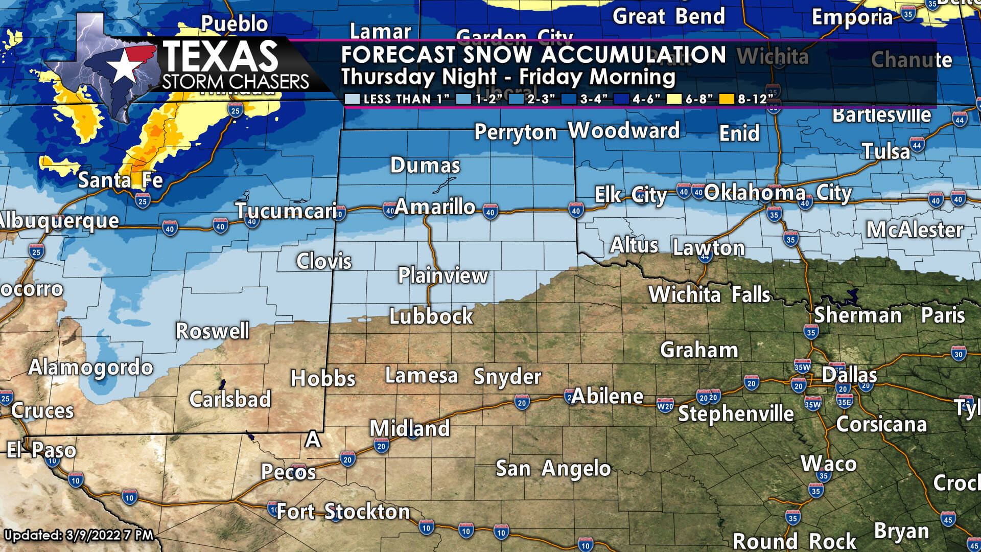
Roads may become snow-packed and slick Friday morning. Some gusty winds may also help blow some snow around, reducing visibilities. Precipitation will end by Friday afternoon.
Further south and southeast, minor accumulations of snow and sleet could occur across West Texas, Northwest Texas, and Texoma. Precipitation amounts look quite light, so the probability for widespread travel impacts is lower. A few slick bridges and overpasses are possible in Northwest Texas and Texoma – including north and northwest of the D/FW Metroplex.
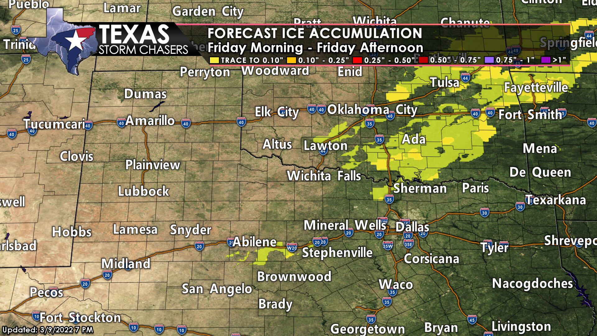
Warmer ground temperatures, light precipitation intensity, and gusty north winds will probably keep surface roads in good shape. Weather models have also trended drier for these regions, making the upcoming winter weather minor to a non-event.
We’ll keep an eye on data for changes over the next 36 hours. Outside of the Texas Panhandle, winter precipitation is looking like a minor/short-duration issue (if even an issue at all). All winter accumulations are likely to melt Saturday morning as temperatures soar well above freezing.


0 Comments