
Outside of the Texas Panhandle, where winter has already arrived this morning, we’re expecting a spring-like day across Texas. Enjoy the warmth, because temperatures will be thirty to forty degrees colder within 24 to 48 hours. We’re not dealing with a record cold, long-lasting event, but we will see a brief return to winter across Texas tomorrow and for the morning hours on Saturday. A majority of this discussion will be for the winter weather chances late tonight and tomorrow. We do discuss temperatures toward the end, so scroll on down if that’s your curiosity.
Texas/Oklahoma Panhandles Tonight & Friday Morning
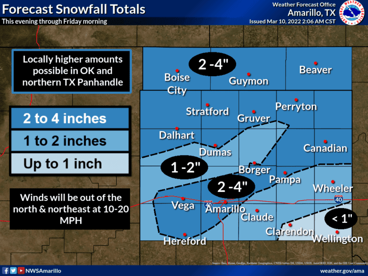
Snow will begin in the northern Texas Panhandle around midnight. We’ll see a rapid uptick in coverage and snowfall intensity over the pre-dawn hours Friday. Snow will likely fall for the Friday morning commute in the Texas Panhandle, resulting in snow-packed roads.
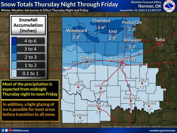
Snowfall accumulations of one to four inches are expected tonight and Friday morning across the Texas Panhandle. Gusty north winds will blow some of that snow around, reducing visibility. Snow-packed roads will result in hazardous travel conditions beginning early Friday and continuing through Friday afternoon across the Texas and Oklahoma Panhandles.
We’ll see conditions improve tomorrow afternoon as the weather clears. Temperatures will rise well above freezing on Saturday, resulting in the rapid melting of any snow accumulations.
West Texas east through Texoma & North Texas Tomorrow
Further southeast in Northwest Texas, Texoma, and North Texas, we anticipate patchy light rain early Friday morning. Temperatures will be falling behind a strong cold front. As surface temperatures drop below freezing west and north of the immediate D/FW Metroplex, any ongoing precipitation will likely change to freezing rain, sleet, or light snow.
Unlike the Texas Panhandle, we only expect light precipitation in Northwest Texas, Texoma, and North Texas tomorrow. We do not anticipate widespread, significant travel impacts in those regions. Slick spots on roadways are likely tomorrow in Northwest Texas, including Wichita Falls, where temperatures will be in the middle to upper 20s.
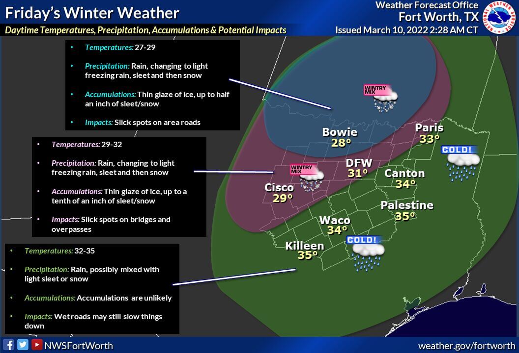
In the D/FW Metroplex, we may see patchy slick spots on bridges and overpasses across the northern and western metroplex. Those in Fort Worth, Dallas, south, and east look to see little to no road impacts. That being said, Mother Nature often throws a few surprises into the forecast, so we’ll be keeping a close eye on the data to ensure no last-minute ‘gotcha’ moments.
A dusting to perhaps just enough sleet and snow to cover the ground is possible in Northwest Texas, Texoma, and the western/northern D/FW Metroplex tomorrow morning and tomorrow afternoon. We’ll need to watch bridges and overpasses, especially northwest of the D/FW Metroplex and up into Wichita Falls to Childress.
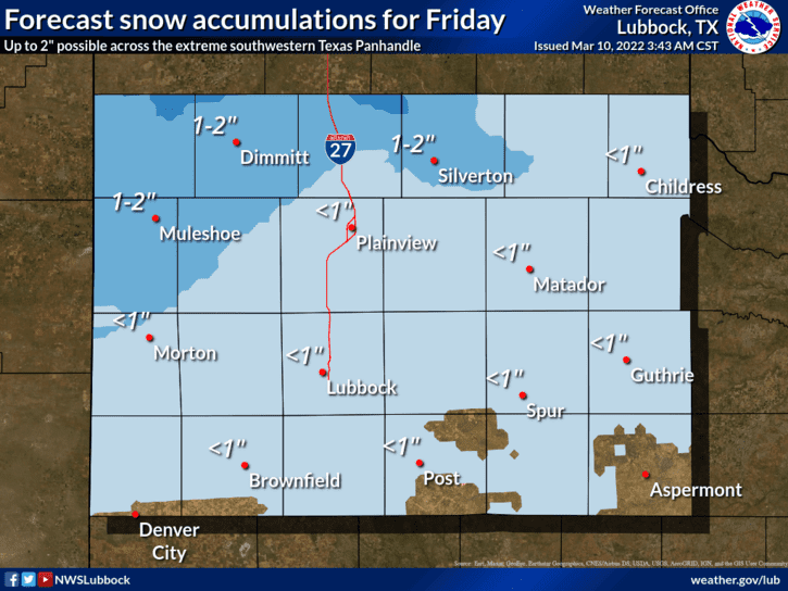
In Northwest Texas, temperatures will be cold enough that some surface roads may become slick in spots – especially if we have freezing drizzle and sleet versus snow. Tomorrow’s winter weather looks to be a ‘minor’ event, but let’s not forget that it only takes one icy bridge to cause havoc. Don’t drive around like Speed Racer.
Cold Saturday Morning; but rapidly warming up this weekend
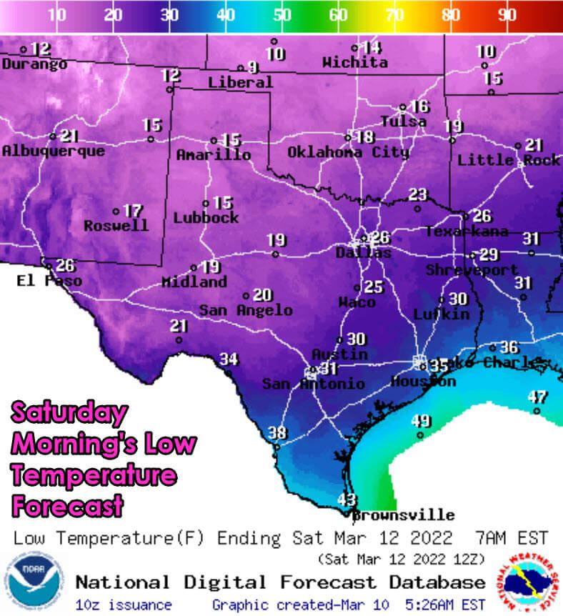
Temperatures will fall below freezing across the northern 75 percent of Texas by Saturday morning. We’re expecting a hard freeze, with temperatures in the teens to middle twenties, from the Hill Country, Central Texas, and the northern Brazos Valley northward.
It’ll be pretty chilly along the Texas coast and across South Texas. Those who have already planted will need to take preventative measures to protect plants. If you’re one of the folks who will drop below 25 degrees, I’d also recommend shutting off water to your outdoor faucets.
Warm weather fans will not hate this weekend’s weather forecast. One benefit of us approaching early spring is that these cold air masses don’t typically stick around long. That’ll be the story this weekend as a rapid warmup occurs. We’re anticipating high temperatures on Saturday to top out in the 50s and 60s.
We’ll see a plethora of 70s arrive on Sunday and Monday. Next week looks pretty spring-like, which means the chance for spring-time thunderstorms may not be too far off. If nothing else, we need to get some widespread rains ASAP, or we’re going to be in a world of trouble in the wildfire department.


0 Comments