
March weather in Texas can flip faster than a gymnast in the Olympics. I’m afraid this week will prove that as we take a ride on the temperature roller-coaster. Up and down we’ll go, and where we’ll end up by Friday? Only God knows at this point, though it’s going to be on the cold side. On the positive side, severe thunderstorms don’t appear to be in our mix this week. On the flip side, a different kind of ‘mix’ is becoming more likely – and it isn’t the kind most of us (myself included) wanted to deal with again this winter.
Tonight & Tuesday
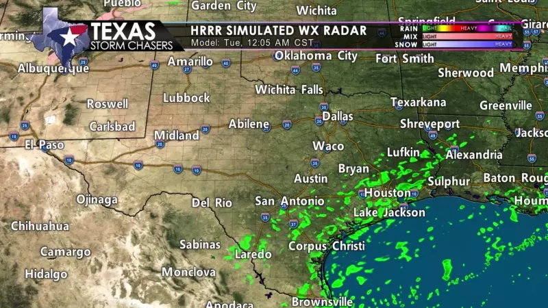
First off and through tomorrow, we’re likely to see spotty showers across the eastern half of Texas. Precipitation intensity and amounts will remain light, but it’ll make for wet roads and the ‘fun’ that comes with that. Temperatures aloft may be cold enough to support a few sleet pellets in North Texas. Surface temperatures will remain safely above freezing, and no accumulations are expected, just like this morning. It beats having brush fires and smoke blowing around.
Wednesday through Friday
Wednesday will be our climb-up-the-temperature roller-coaster day. We’ll enjoy warmer temperatures than today and tomorrow, and that trend will continue into part of Thursday. The excellent news for warm-weather fans is that temperatures on Thursday will likely climb up into the 60s and 70s. The bad news for warm weather fans is that an arctic cold front will knock us back down into ‘winter’ by Thursday Night into Friday.
The timing of the front will fluctuate, but I wouldn’t be surprised if it is through the northern half of Texas by dinner-time Thursday. It should be knocking on the Gulf Coast’s door during the first half of Friday. South Texas will enjoy a toasty Friday before temperatures get knocked back down Friday night. Our late-week cold front will be one of those “drop 20-30 degrees and blistery north wind within an hour” sort of deals.
Winter Mischief… again
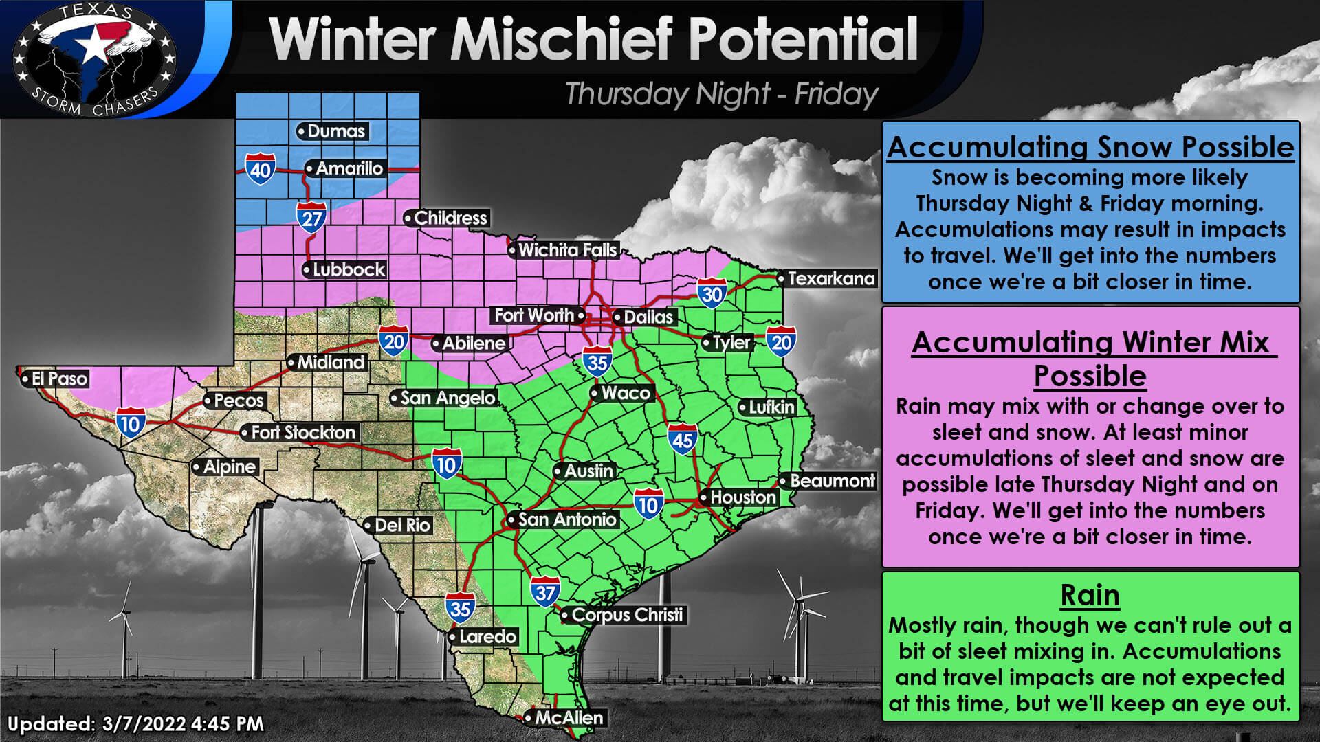
Like several events this winter, we’ll see an upper-level storm system move overhead as colder air is in place late Thursday into Friday. Once again, we’re looking at the possibility of ‘winter mischief’ across parts of Texas. Timing of the cold front will play a role in the southern extent of the rain/snow line, and we’re still dealing with varying solutions on the type and amount of precipitation.
At least light winter precipitation is becoming more likely across the Texas Panhandle, Northwest Texas, Big Country, Texoma, into North Texas late Thursday night and on Friday. Snow should be the main precipitation type in the Texas Panhandle, and snow/sleet should be the primary ‘winter mischief’ type further southeast where temperatures become cold enough. Otherwise, we are expecting light rain where surface temperatures remain above freezing. Precipitation should exit Texas to the east by Friday evening.
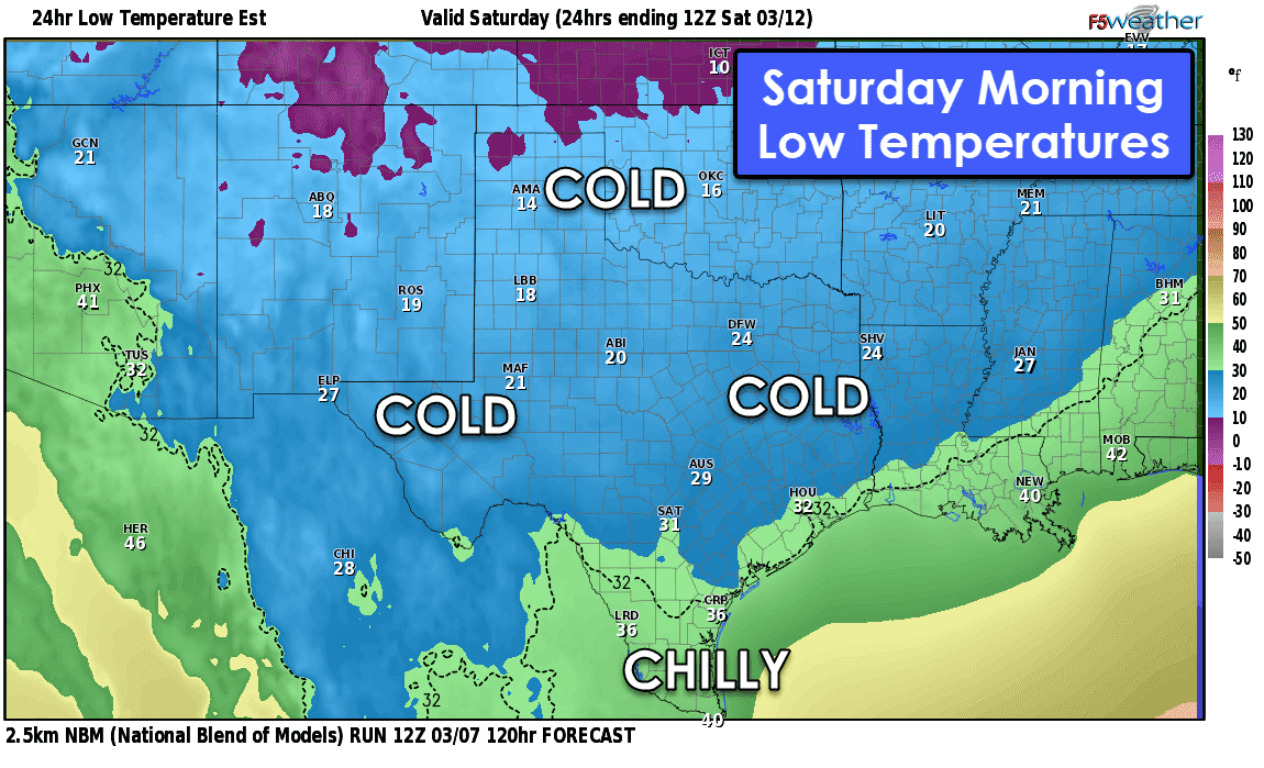
It is too soon to speculate on specific precipitation accumulations (snow, sleet, freezing rain, or any). However, minor accumulations appear probable, and some travel impacts may occur. We are getting more daily sunlight than in January or February, which may help keep some surface objects warmer or melt faster. I wouldn’t go changing plans just yet, but I would advise folks to stay up-to-date with the latest forecasts over the coming days. It is going to be cold across the entire state by Saturday morning.
A rapid warm-up will occur on Saturday and into the weekend, so any ‘winter mischief’ will not last too long.


0 Comments