
Active weather will return to Texas starting tomorrow and continue through the weekend. At this time, we’re watching Friday and Saturday for potential severe thunderstorms. We’ll also have good rain chances and much-needed rainfall to help jump-start the spring growing season.
Tomorrow’s Severe Weather Forecast
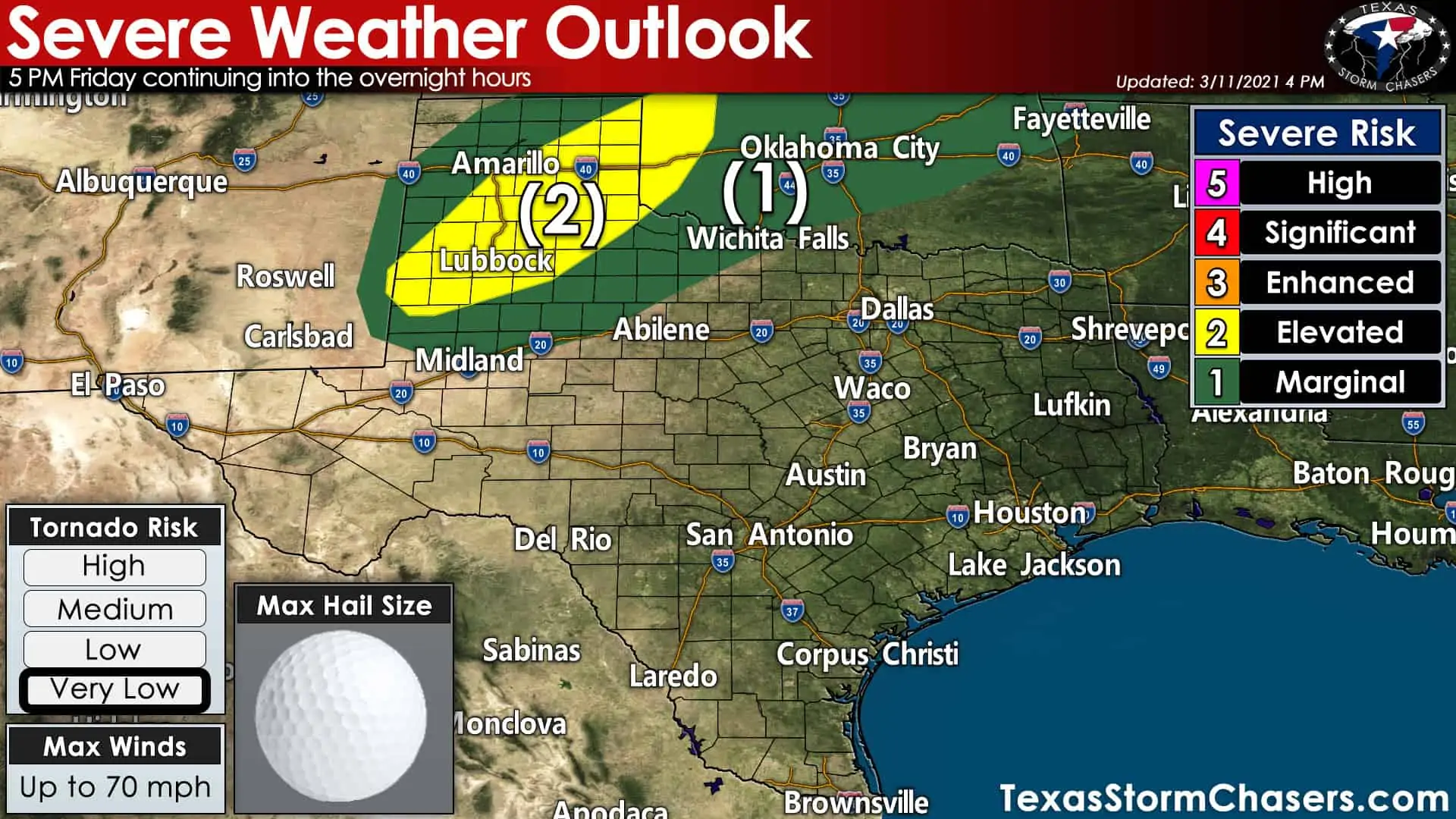
The Storm Prediction Center has issued a level two risk of severe weather for the southeastern half of the Panhandle and a good chunk of West Texas. A level one risk of severe weather includes the northern Permian Basin, West-Central Texas, and Northwest Texas. Severe weather is possible in both risk zones. Still, a higher number of severe weather occurrences are expected in higher severe weather probabilities. Tomorrow’s severe weather threat looks to begin around dinner-time, so much of the daytime should remain quiet. Large hail up to the size of golf balls and wind gusts up to 70 miles per hour are the primary threats. A conditional risk for a few tornadoes may exist in the level two risk zone tomorrow evening if enough surface-based instability can develop.
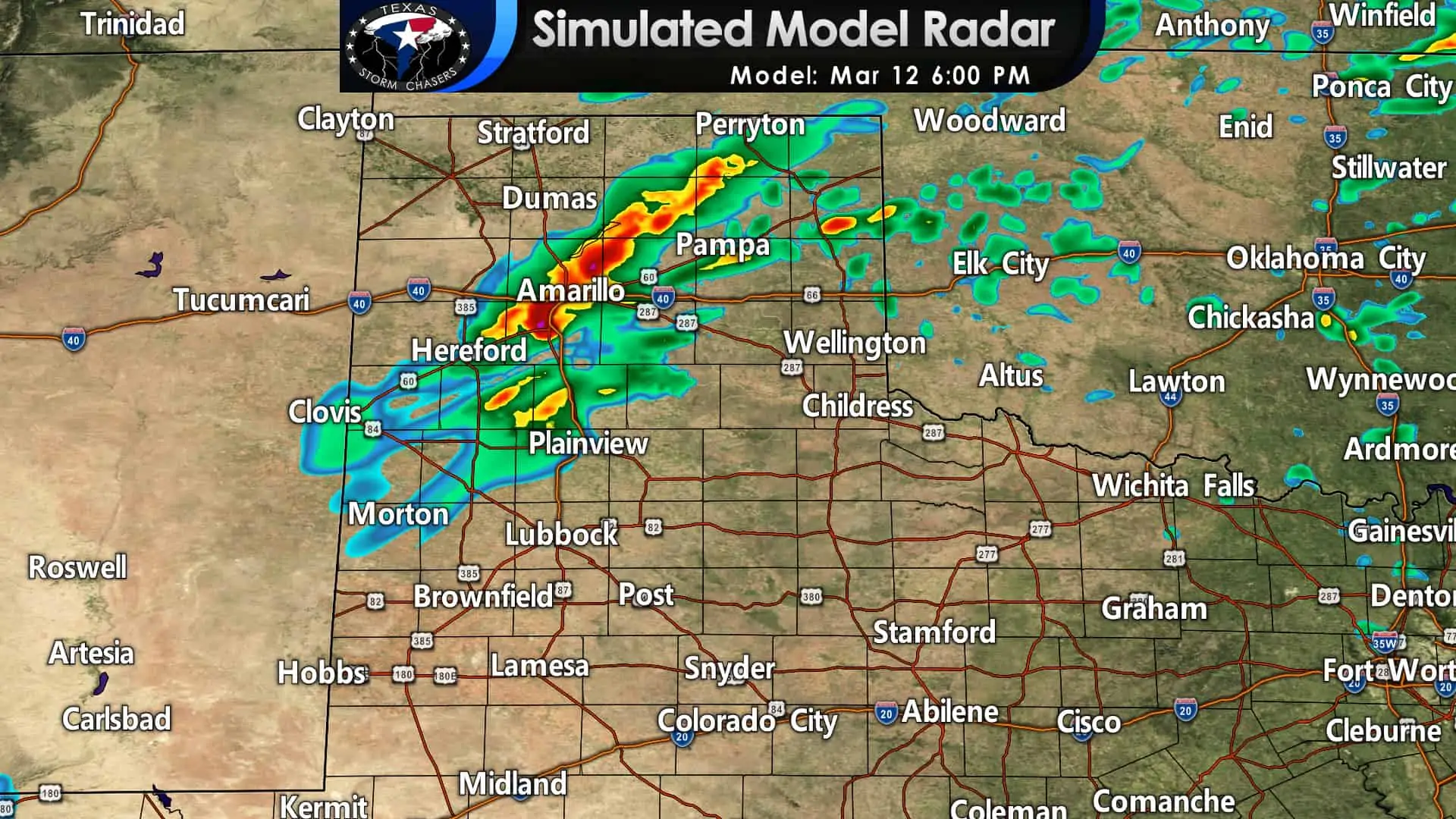
Thunderstorm coverage and intensity should be on the increase after 5 PM tomorrow in the Texas Panhandle and portions of West Texas. Some data suggests storms getting rowdy around dinner-time. Other weather models say we may have to wait until after 8 PM. Either way, tomorrow’s severe weather threat should mostly be after sunset to the woe of those storm chasing. Storms will move northeast at a fast clip.
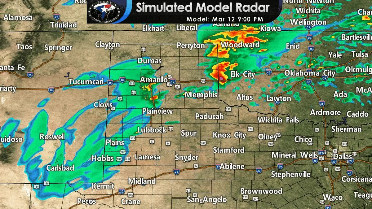
Scattered to numerous thunderstorms are likely tomorrow evening and tomorrow night across the Texas Panhandle and West Texas. The strongest storms will probably be capable of producing large hail and damaging wind gusts. As discussed previously, there is a conditional risk for a few tornadoes if the ingredients can fall into place. Localized heavy rain and dangerous cloud-to-ground lightning are expected with any storms tomorrow night. The threat for severe storms should decrease after midnight, but we’ll continue to see precipitation for much of the night. The dryline will slowly retreat west tomorrow evening into eastern New Mexico. Increased moisture and potential rain chances will also increase for the western Panhandle tomorrow night.
Saturday’s Severe Weather Chances
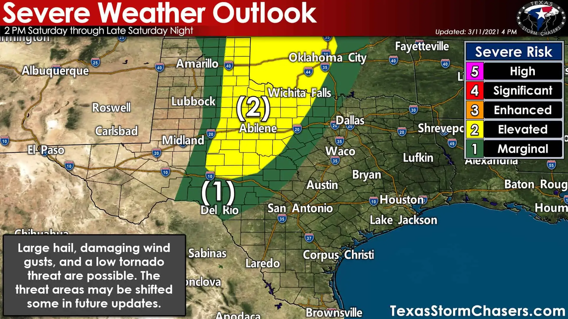
Thunderstorm chances will shift and expand eastward on Saturday in conjunction with the dryline. A level two risk of severe weather includes the eastern Texas Panhandle, West-Central Texas, the Big Country, the Concho Valley, Northwest Texas, and western North Texas. A level one risk of severe weather includes the northern Edwards Plateau and western portions of the D/FW Metroplex. Severe weather is possible in both risk zones. Still, a higher number of severe weather occurrences are expected in higher severe weather probabilities. We expect there will be refinements to the risk zones and locations in future outlook updates. Don’t pay much attention to where each risk zone is drawn, but consider it a ‘heads up’ if you’re near or within any of the risk zones.
Unlike tomorrow, Saturday’s thunderstorm chances should begin during the early afternoon hours. The initial storm mode may be supercelluar with a risk of large hail, localized damaging wind gusts, and a low tornado threat. After a few hours, storms should grow upscale into a squall line that moves east into Saturday Night and Sunday. Damaging straight-line winds, brief tornadoes, and hail are possible with stronger storms Saturday evening and Saturday night with the eastward-moving squall line.
We’ll need to nail down the specific small-scale features along with the exact timing for Saturday’s severe weather setup. Some of tomorrow’s storms may also influence Saturday’s setup. We should see a fairly good coating of rain with the squall line Saturday evening into Sunday. The squall line will start outrunning instability as it moves east and approaches Interstate 35. We’ll still see showers and storms for I-35 Sunday morning, but they should be in a weakening phase (so a few strong storms, but a lower chance for severe wind/hail versus farther west). Thunderstorms may redevelop/become stronger Sunday afternoon across Northeast Texas and East Texas. We’ll deal with the Sunday storm chances once we get past tomorrow and nail down timing/smaller-scale features.
Weekend Rain Forecast
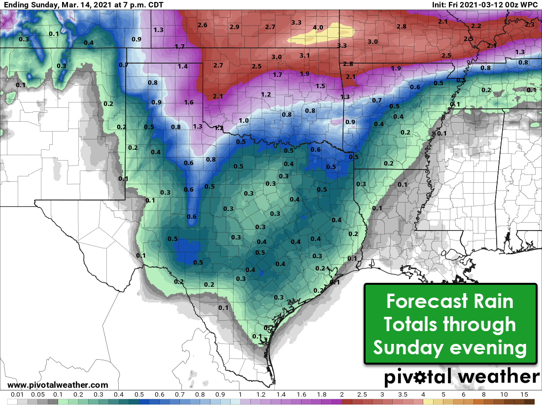
It isn’t April fools, though you’d be correct in suspecting it after I tell you that the heaviest rains are expected to be in the Texas Panhandle. Yup, a region normally missing out on rain is going to be getting plenty of it over the next few days. We’ll see a good coating of rain (one-quarter to one-half inch) across the eastern seventy-five percent of Texas by Sunday afternoon. Those up in the Panhandle should pick up one-half to one and a half inches of rain. Locally higher amounts are likely across Texas, with brief periods of nuisance flooding possible. Dry soils and fast-moving storms should prevent any higher-end or widespread flooding. We’ll be done with thunderstorms by Sunday evening in Texas. We’ll switch gears and get to deal with a strong cold front thereafter. Snow may fly across parts of the Panhandle. However, let’s be clear that we’re not talking about a record-breaking/power-grid debilitating cold snap in any way, shape, or form.


0 Comments