
The 2021 Spring Severe Weather Season begins today for Texas. We try not to reference ‘severe weather seasons’ much anymore since we can have severe storms any month of any season. Yet, spring does typically bring the highest concentration of severe weather days to our little part of the world. California has earthquakes, Minnesota has blizzards, the Gulf Coast has hurricanes, and the Plains of the United States have tornadoes. Of-course Texas manages to have all of the above, but severe storms are simply a fact of life in Texas. There is no reason to worry, panic, or go running around the yard in your birthday suit. Those reading this post are already better off than a lot of folks simply because you’ve empowered yourself with information.
A brief explanation of how severe weather outlooks are created
The Storm Prediction Center is responsible for issuing severe weather forecasts for the continental United States. For the last several years they have utilized a five-level risk system to convey severe weather possibilities. One is the lowest while five is the highest. Severe weather outlooks are based on the probability of severe weather occurring within 25 miles of any given point – like your home. I’ve chased mile-wide violent tornadoes in a level one risk and have been chased by violent tornadoes in a level five risk.
Any risk level should be considered a ‘heads up. We don’t want folks to get bogged down on where the risk lines are drawn or what risk level any one spot is in. Mother Nature never taught storms how to read risk maps. For those adventurous types interested in learning more about severe weather outlooks tap here.
Today’s Severe Weather Threat
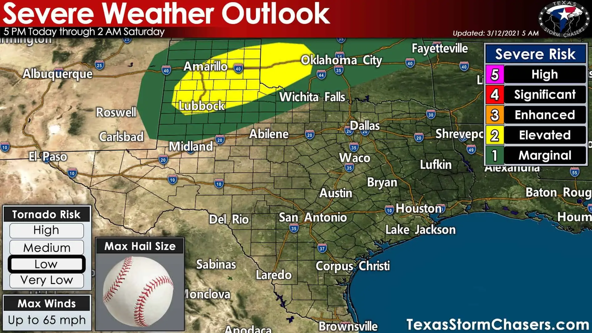
Today’s severe weather outlook from the Storm Prediction Center. The outlook will be updated several times throughout the day, so please check back for updates this afternoon.
Severe thunderstorms are possible late this afternoon through the evening hours in the Texas Panhandle, West Texas, and Northwest Texas. The strongest storms may be capable of producing hail up to the size of baseballs, localized wind gusts up to around 65 miles per hour, and isolated tornadoes. A small section of Northwest Texas and Southwest Oklahoma may be upgraded to a level three risk in later outlooks. Severe weather threats would remain the same, but there may be multiple severe storms within that corridor (hence, higher chances of severe weather).
Today’s Tornado Potential
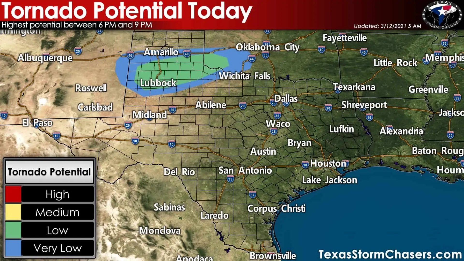
Today’s tornado risk is low. Isolated tornadoes will be possible between 6 PM and 9 PM across West Texas, Northwest Texas, into Southwest Oklahoma. Large hail and damaging straight-line winds should be the predominant severe weather threats. Of course, if there’s only one tornado this evening and it goes through your town, that would be a big-time event for you. Most of today’s severe weather threats will occur after sunset – making it more difficult for storm spotting operations.
Today’s storm timing and details
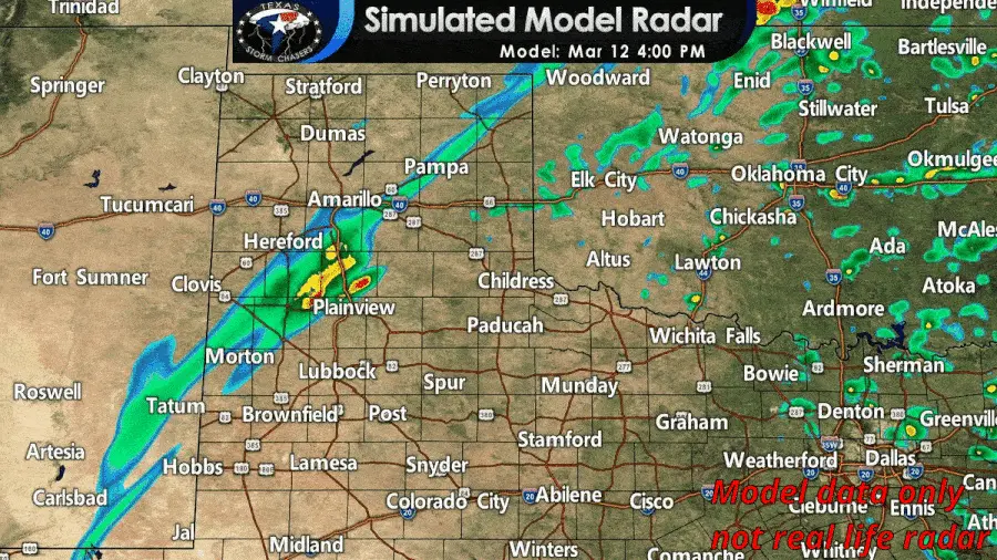
A simulation of what the weather radar may look like later today and tonight. Do not expect this model’s simulation to have exact storm-scale features or storm locations completely correct. However, it does provide a useful ‘approximate timeline’.
Most of the day will be quiet in the thunderstorm department. We should start to see our first storms fire up around 4 to 5 PM just east of a dryline in West Texas and in the Panhandle. For the first several hours after thunderstorms develop we anticipate a supercelluar storm mode. The most intense storms could produce damaging hail up to the size of baseballs, wind gusts of 60 to 65 miles per hour, and even an isolated tornado or two. We may see a slightly enhanced tornado threat between 6 PM and 9 PM in Far Northwest Texas.
After 8-9 PM we should start to see thunderstorms grow upscale into one or more broken line segments. Hail, localized damaging wind gusts, and heavy rain will remain likely with the most intense storms. The dryline will retreat west after sunset and additional thunderstorms may develop farther west this evening. Those additional storms, some of which may be severe with large hail, could impact Lubbock to Amarillo after 9 PM. The High-Resolution Rapid Refresh (HRRR) model has storms decreasing in intensity around midnight and moving into Oklahoma. Scattered showers and storms may continue into early Saturday across West Texas and the Panhandle.
Saturday’s Severe Weather Threat
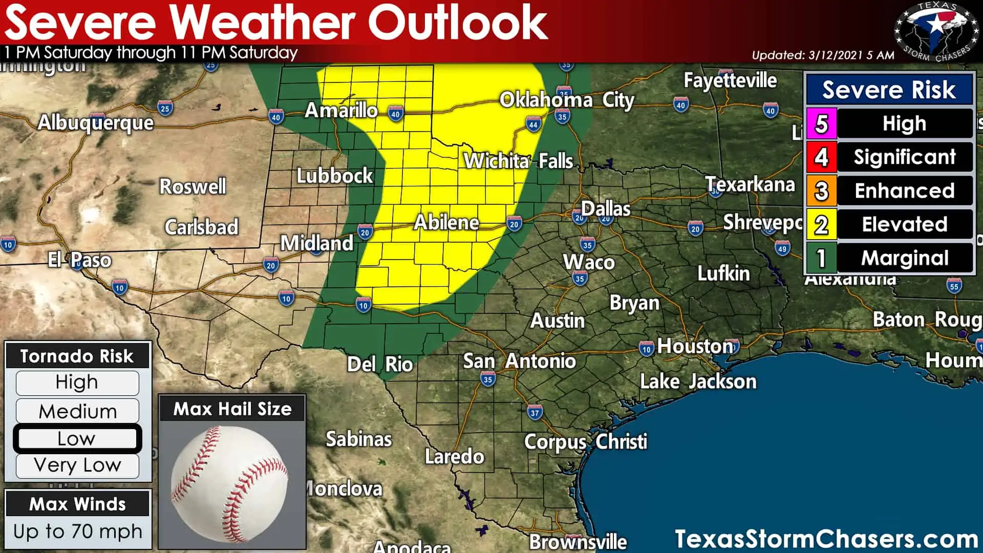
Saturday’s severe weather outlook from the Storm Prediction Center
After retreating west tonight, the dryline will begin pushing east with haste on Saturday as an upper-level storm system gives it a good ‘ole kick. Severe thunderstorms are possible in the Concho Valley, Big Country, Northwest Texas, extending northwest up into the Texas Panhandle. Initial thunderstorms in the Texas Panhandle and Northwest Texas may be capable of producing large hail, localized damaging wind gusts, and a few tornadoes Saturday afternoon.
As the dryline continues pushing east we should see a nearly solid line of thunderstorms develop and move east across the risk zones. Damaging straight-line winds, brief tornadoes, and hail would be possible with the most intense storms Saturday afternoon and Saturday evening. Storms will start running into a less unstable airmass as they enter North Texas and the Hill Country Saturday evening. Rain chances will remain high, but we should see storms weaken below severe limits not long after they reach Highway 281.
Saturday Night & Sunday Morning
Numerous showers and thunderstorms are expected Saturday night and Sunday morning across the eastern half of Texas. The severe weather threat is uncertain, but it looks like the atmosphere may be stable enough to preclude too many issues. We’ll have to keep an eye out in case a localized/marginal hail or damaging wind threat develops. Otherwise, we expect beneficial rains, but not heavy enough to cause flooding. Showers and storms will end from west to east Sunday as the dryline continues to advance east. We’ll probably be done with precipitation not long after lunch-time on Sunday.
Severe weather coverage and storm chasing notes
Our team is gearing up to provide severe weather coverage later today and on Saturday. I’ll be in the office to provide real-time severe weather updates and several of our team will be out chasing. Make sure you’ve downloaded our free mobile app to find out when live storm chasing video and severe weather coverage is available! You can also visit our live video page here. I’ll have another detailed forecast update out not long after lunch-time and we’ll get the ball rolling from there.


0 Comments