
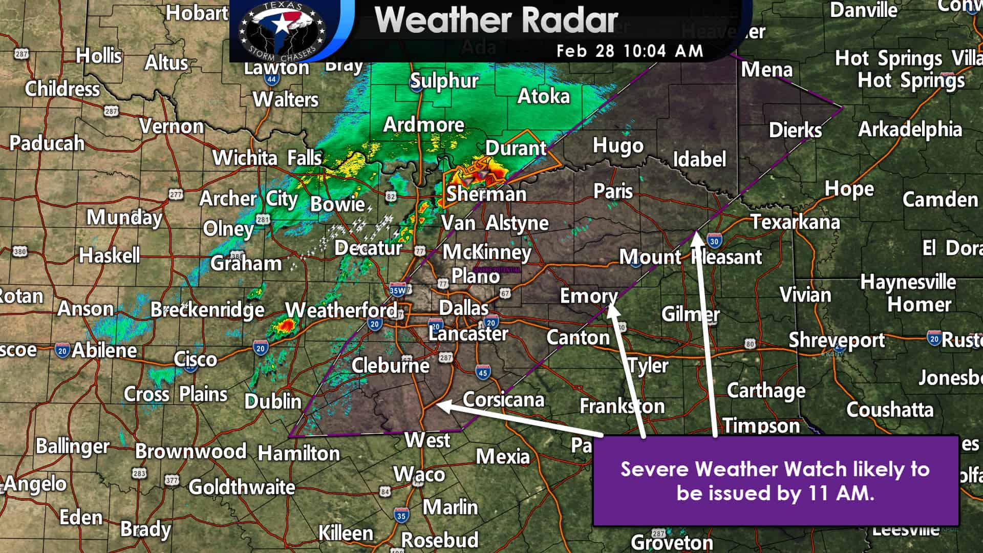
The Storm Prediction Center has indicated a severe weather watch will likely be issued soon for North Texas and Northeast Texas. Our first severe thunderstorm of the day produced quarter-size hail in Gordonville and Whitesboro a few minutes ago. Additional thunderstorms are expected to develop over the next few hours. The strongest thunderstorms will produce large hail up to the size of golfballs, localized damaging wind gusts up to 65 MPH, and heavy rainfall. While the tornado threat is low, we can’t rule out a tornado with storms through the afternoon hours. Not all storms will be severe. Please see my detailed forecast posted here on the blog around 8 AM for a more detailed timeline through tomorrow. You can also keep track of the storms with our interactive weather radar here on our website and within our free mobile app.
Mesoscale Discussion 0135
NWS Storm Prediction Center Norman OK
0959 AM CST Sun Feb 28 2021
Areas affected…northeast Texas through southeast Oklahoma and
southwest Arkansas
Concerning…Severe potential…Watch likely
Valid 281559Z – 281730Z
Probability of Watch Issuance…80 percent
SUMMARY…Thunderstorms are expected to increase in coverage and
intensity by late morning into the afternoon. Primary threats will
be isolated large hail and damaging wind gusts, though a tornado or
two will also be possible. A WW will likely be needed before 17Z.
DISCUSSION…As of mid morning a cold front extends from eastern OK
through north central and west central TX. An isolated thunderstorm
with mid-level updraft rotation has developed on the front and is
located just east of Gainesville with another isolated storm near
Mineral Wells. The downstream warm sector is already moderately
unstable with 1000-1500 J/kg MLCAPE supported by upper 60s F
dewpoints and 7-7.5 C/km mid-level lapse rates. Further
destabilization will occur, but will be limited to some degree by
widespread multi-layer clouds. Weak, progressive impulses embedded
within the southwesterly upper flow regime and forcing along the
cold front will contribute to an increase in thunderstorm coverage
later this morning as the boundary layer slowly warms. The primary
low-level jet has shifted east of this region resulting in small 0-1
km hodographs. However, a belt of strong southwesterly winds
increasing to around 70 kt at 500 mb resides above the warm sector
and is contributing to 60+ kt effective bulk shear. Therefore, some
storms should organize with supercells and bowing segments likely,
eventually consolidating into a dominant linear mode. Large hail and
isolated damaging wind will be the main threats. The small low-level
hodographs should tend to limit overall tornado threat. However, a
tornado or two cannot be ruled out.
..Dial/Hart.. 02/28/2021


0 Comments