
The southeastern two-thirds of Texas is quite muggy this morning. Dewpoint temperatures are in the middle to the upper 60s, with 70-degree dewpoints along the coast. Those are impressively high dewpoint values for February. All of that is to say we have a lot of moisture in place. Of course, many of you are probably walking outside to fog or mist – another good way to tell there is moisture. The opposite is true across the Texas Panhandle, West Texas, and western Oklahoma, where a cold front has blown through. It is that cold front we’ll be watching today for increased thunderstorm chances.
Today’s Severe Weather Outlook
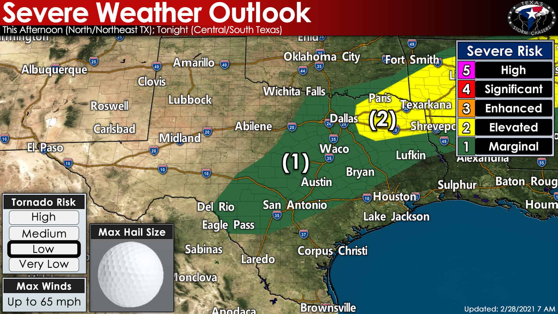
A level two out of five risk of severe weather has been issued for eastern North Texas and Northeast Texas. A level one out of five risk of severe weather includes North Texas, Central Texas, the Hill Country, Edwards Plateau, Brazos Valley, and East Texas. The higher the risk number, the higher the chance of severe storms impacting your region. You can find a complete explanation of the severe weather risk scale and how it is calculated here. Hail and localized damaging wind gusts are the primary hazards with the most intense storms today and tonight. Not all storms will be strong enough to produce hail and high wind.
Today’s Tornado Threat
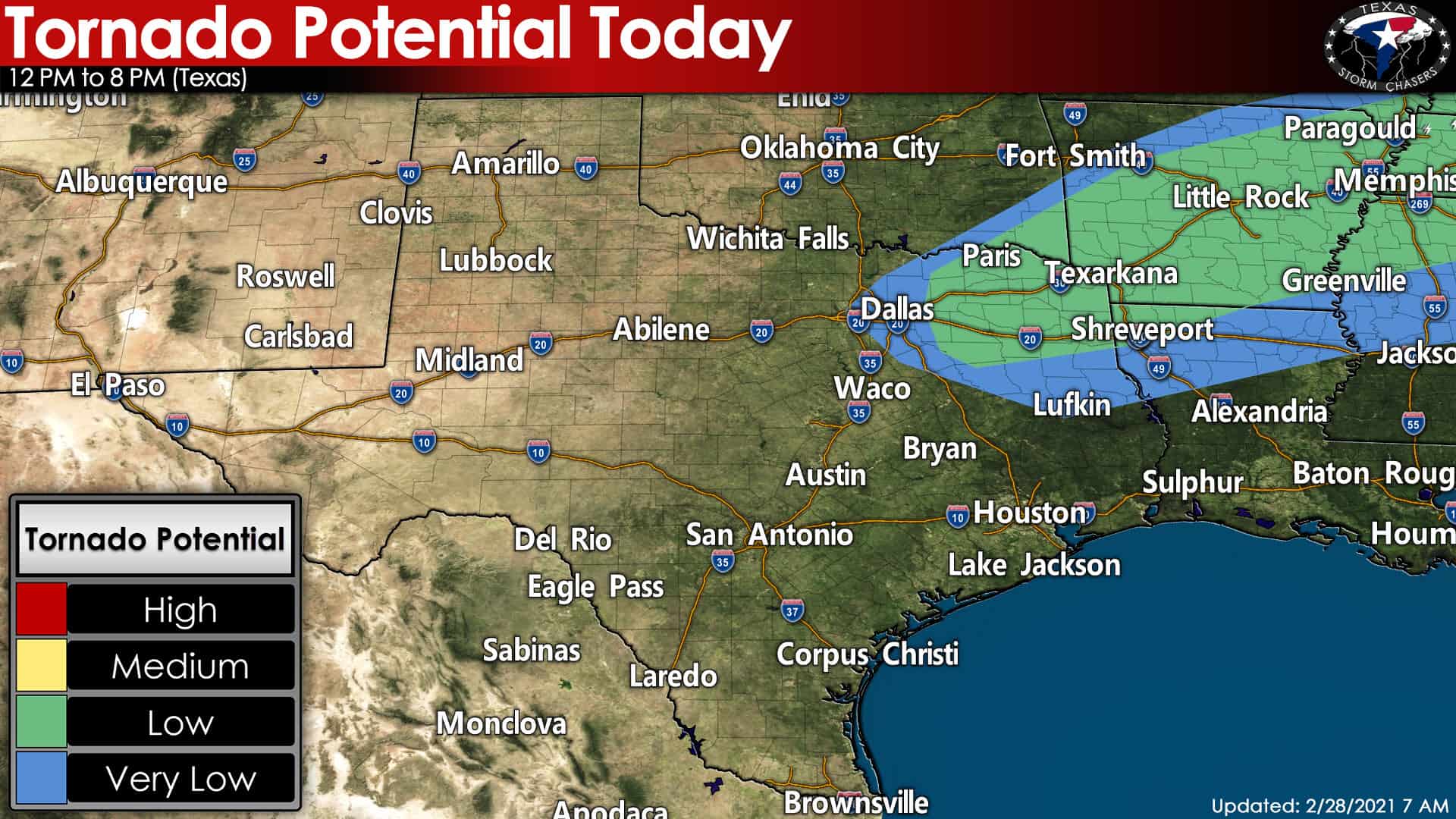
There is a low chance of a tornado this afternoon in Northeast Texas. I do believe the higher threat for a few tornadoes will be tonight in Arkansas and Tennesee. However, we can’t rule out a tornado this afternoon in eastern North Texas or Northeast Texas. Today’s storm setup is not one that strongly favors a tornado risk. Still, one must always expect the unexpected when it comes to Mother Nature. We’ll keep an eye out just in case a small corridor of slightly-higher tornado potential can develop. As it stands now, today is a hail/gusty wind/heavy rain sort of day versus a ‘spinny things of doom lofting cows and the wicked witch’ day.
Storms will produce heavy rain…
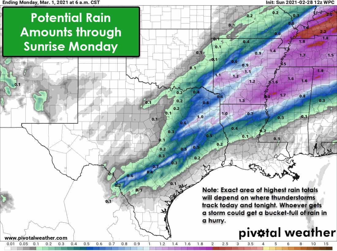
Regardless of any severe weather mischief today, we will see heavy rainfall with any storms that fire up. The amount of moisture in the atmosphere is comparable to what one would expect in May. It will be quite easy for most showers and storms to produce heavy rainfall amounts. Don’t be surprised if you pick up a quick one to two inches of rain should you end up under a heavy boomer.
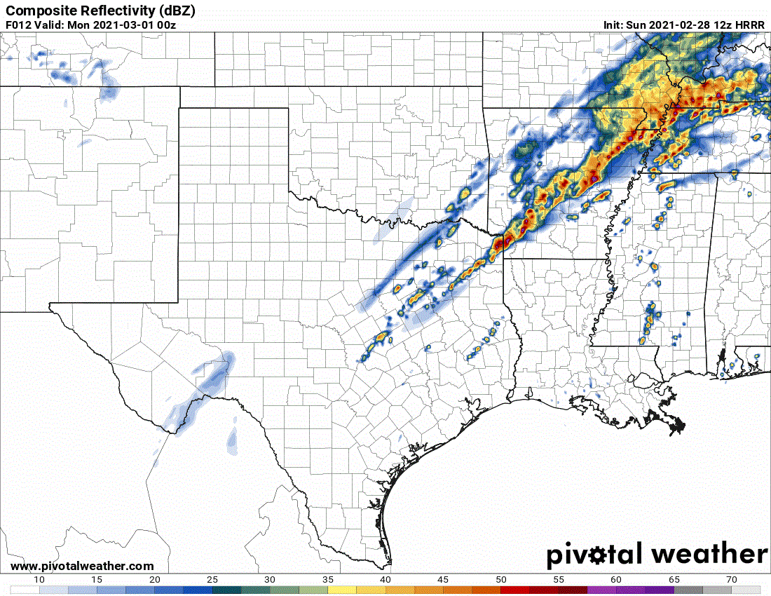
Storm Timing Details
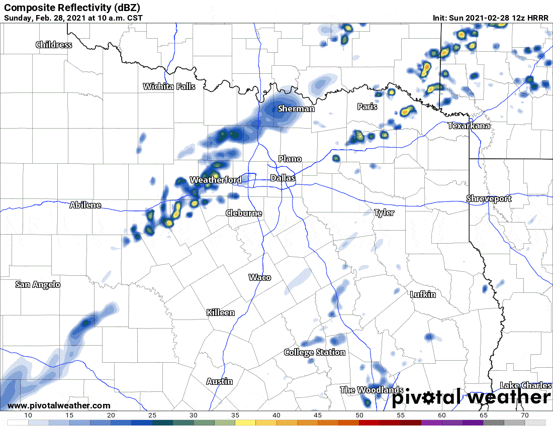
Simulated weather model radar from the 6 AM High-Resolution Rapid Refresh (HRRR). This simulated radar is from late this morning through 6 PM. Please remember that models are just a guesstimate – and while they’re good, they’re not perfect.
Isolated to widely scattered storms are possible by late-morning across North Texas and Northeast Texas. The strongest storms could produce large hail, localized damaging winds, and heavy rainfall. A tornado can’t be ruled out, but the overall threat should be low. We may have to wait until this afternoon for storms to get going. Storms would move east/northeast and could continue through the mid-afternoon hours in North & Northeast Texas. At the same time, we’ll see a cold front slowly move southeast. The highest threat for more intense storms will be near and ahead of the cold front today. As the simulated weather model image above shows, we’re generally expecting a cellular/pulsing storm mode. Weak low-level winds are precluding a higher tornado threat. Weather models, especially ones trying to guesstimate cellular storm development/timing/locations, can easily be off – so don’t assume the radar will look exactly like a model shows.
Simulated weather model radar from the 6 AM High-Resolution Rapid Refresh (HRRR). This simulated radar is from 6 PM today through 12 PM Monday (three-hourly progression). Please remember that models are just a guesstimate – and while they’re good, they’re not perfect.
Storms will be possible late tonight in Central Texas, the Hill Country, and Brazos Valley. We’re still a bit uncertain about the strong storm threat tonight. Hail up to the size of quarters would be possible with the most intense storms tonight. Regardless of any hailers tonight, we’ll see precipitation chances increase late tonight and Monday morning across those regions plus South-Central and Southeast Texas. Tomorrow looks to be wet with a chance of locally heavy rainfall. Severe storms are not expected during the day Monday, just a cool rain.


0 Comments