
Welcome to the twelfth week of 2021! I hope you all had a good weekend. It was nice being able to enjoy the early-spring weather without having to worry about spring storms. Unfourtanietly, today’s weather is not going to be so nice. Rain is expected to move from west to east this morning and through the early afternoon across Texas’s western half. This morning’s activity will not be severe and should remain on the light side. By early afternoon we’ll see the first round of rain moving eastward across the Hill Country northward into Oklahoma. Again, no severe weather is expected with round one. Things could become more interesting for round two if a few conditions are met.
- The atmosphere would need to destabilize after round one. That destabilization process can happen relatively quickly with strong lift in place from an upper-level storm system. Will it have time, though? How far east will the atmosphere destabilize (assuming it does at all)?
- Assuming we do have stronger/severe storms this afternoon and evening – how far east will the threat extend?
- Will round two feature ‘elevated storms’ with heavier rain and hail – or will they be ‘surface-based storms’ with damaging winds and a few tornadoes also in the mix?
- How far south will round two develop this evening? Will stronger storms remain in the Big Country/North Texas – or extend farther south into the Hill Country and Central Texas?
As you can tell from my list of factors, today’s threat for severe weather is far from locked in, especially in the Big Country, Northwest Texas, and North Texas. Likewise, I can’t rule out an isolated severe weather threat farther south into the Hill Country and Central Texas tonight. Let’s look over the latest severe weather outlook from the Storm Prediction Center.
Today’s Severe Weather Outlook
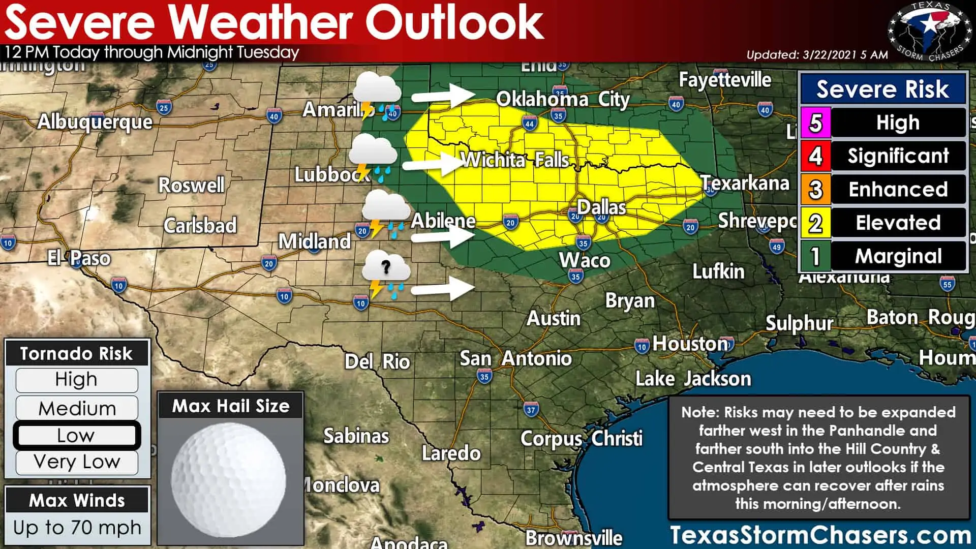
The Storm Prediction Center has highlighted a threat of strong to severe storms this afternoon and evening. The risk’s western edge includes the eastern Texas Panhandle, West-Central Texas, southward into the Big Country. It runs east to include Northwest Texas, Texoma, North Texas, and Northeast Texas. A level one and level two risk are included in this morning’s outlook. Severe weather hazards are identical in both zones – the chance of severe weather is higher (probability-wise) the more you rise on the scale.
If you’re in or near any risk zone – this is your hint to pay attention to the weather this afternoon and evening. Mother Nature doesn’t give a hoopla about our maps, lines, colors, or fancy terminology. Don’t be surprised if the risk for isolated severe storms ends up being expanded west toward Interstate 27 and farther south into the Hill Country/Central Texas/Brazos Valley in later updates.
Severe Weather Hazards
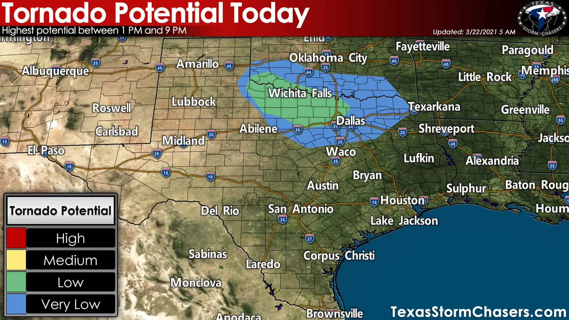
Large hail up to the size of golfballs and damaging straight-line winds up to 70 miles per hour is today’s primary threats. Those would be likely with the most intense storms. Not all storms will be severe, and not all severe storms will produce large hail or wind damage. A few tornadoes are not out of the question, along with localized flash flooding, especially if the atmosphere can destabilize across Northwest Texas, Texoma, and North Texas by early this evening. While instability is in question, wind shear is not. We’ll be watching for signs of brief tornadoes within any squall line or supercelluar storms this afternoon and evening.
We’re going to have plenty of wind shear in all levels of the atmosphere. Today’s severe weather setup is typical of the ‘cool season.’ We have a plethora of wind shear, but the atmosphere isn’t overly unstable. The opposite is usually true in the late spring and summer months. It is when all the ingredients balance out that we can have issues in the stormy-department. Sometimes those ingredients balance out over a small area – sometimes, they end up balancing out across half the state of Texas.
The timing of this morning’s/afternoon’s first round of rain will play a significant role in how severe round two ends up being. If clouds/rain clears out quickly and the atmosphere can destabilize, I expect a relatively busy evening of severe weather. If rain/clouds hold tough and the atmosphere only becomes modestly unstable, the risk for severe storms would be isolated/limited. It’ll come down to watching observational trends this afternoon. As I said, we’re going to have the wind shear later today.
It’s a matter of if the atmosphere will recover/destabilize or if we’ll see a thin line of showers/storms with gusty winds. Cool-season severe weather can be a fickle phenomenon to deal with (as the southeastern United States can often attest to – where these events are commonplace).
Storm timing this afternoon & tonight
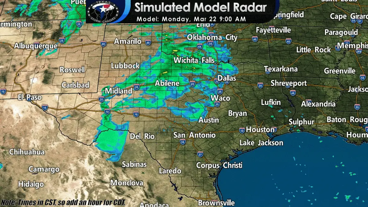
Simulated weather model radar from this morning through late Monday night across Texas. Remember: This is only one model’s guess of what may happen. Do not expect the weather radar to actually look like this depiction tonight.
I’ve described the first round of rain previously, so I’ll focus on the potential round two’s timing. The weather model animation shown above is one of the more aggressive ones in storm coverage and intensity this evening. It is possible storms aren’t as widespread or intense (as described above).
Scattered strong to severe thunderstorms may develop around 12-1 PM just east of a dryline in the Texas Panhandle and West-Central Texas. The earlier storms fire, the closer to Interstate 27 they’ll be. Those in Amarillo south to Lubbock shouldn’t be shocked if a quick-hitting storm fires up around lunch-time. Storms will quickly move off to the east with a threat of large hail and localized damaging wind gusts. Storms should congeal into line segments relatively quickly, but they may maintain semi-discrete storm modes for a couple of hours. A tornado is not out of the question.
By mid-afternoon, a line of thunderstorms may be moving eastward across western Oklahoma, Northwest Texas, and the Big Country. The squall line’s most intense storms could be producing localized damaging winds, hail, and brief tornadoes. Those threats could continue as the squall line quickly moves east into North Texas and Texoma late this afternoon. Storms may be moving into the D/FW Metroplex between 6 PM and 8 PM from the west.
Severe weather could continue along with localized flash flooding into the mid-evening. Depending on how much the atmosphere recovers, we may also have stronger storms further south into the northeastern Hill Country and the northern Brazos Valley). Storms should slowly weaken as they move into a less unstable airmass across East Texas and the Brazos Valley late this evening and early Tuesday morning.
Review your Tornado Safety Plans!
Severe weather is not guaranteed today, but we’re well into March. Stronger storms are not a rarity in the spring in Texas. While severe weather is most common during March-May, we deal with it every month out of the year. Take the time while the weather is quiet to review your severe weather safety plan. Know where you’ll go if a tornado approaches. Don’t make those plans with a tornado five minutes away – make them while the weather is quiet. We’ve got a page full of information on tornado safety here. Make sure you’ve downloaded our free mobile app to get notifications when we publish updated forecasts and new videos.


0 Comments