
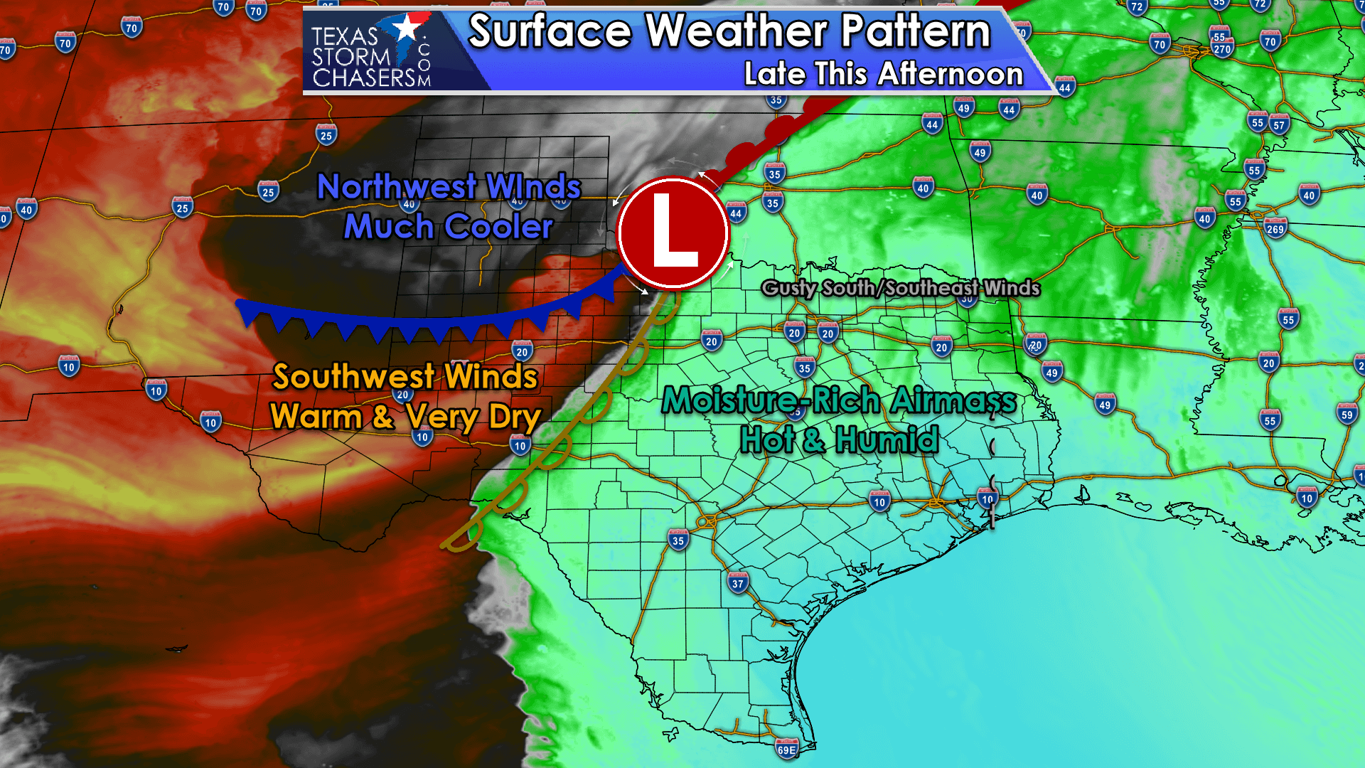
A night-time severe weather event is expected across Texoma and North Texas tonight. The chance for severe thunderstorms is comparatively lower across Central Texas, the Hill Country, and the Brazos Valley. Today will be windy across Texas, but we are not expecting severe thunderstorms to develop until near sunset. We are expecting showers and storms in the Texas Panhandle this afternoon, but those will occur on the cool side of the storm system and should behave.
Today’s Severe Weather Outlook

Any risk zone or color on our map indicates a severe weather threat tonight and early Monday morning. The higher up on the scale, the higher chance of severe storms impacting your immediate area. Risk levels are based on the possibility of a severe storm within twenty-five miles of any given point – such as your home.
The exact placement of each risk zone will probably change as updates are made to the severe weather outlook later today. Those in or near any risk zone should remain weather aware late this afternoon, this evening, and overnight. Storms will be fast-moving and occur during the dark of night.
A level three risk – a one in three chance of severe storms in your immediate area – includes Texoma and the northern D/FW Metroplex. The level three risk runs north of a line extending from Petrolia to Sanger to Allen to Greenville to Bogata and Clarksville.
A level two risk – a one in six chance of severe storms in your immediate area – includes the remainder of North Texas and portions of Northeast Texas. The level two risk runs north of a line extending from Electra to Lakeside City to Jacksboro to Mineral Wells to Gatesville to Temple to Elkhart to Longview and Jefferson.
A level one risk – a one in twenty chance of severe storms in your immediate area – includes the far southeastern Texas Panhandle, the Hill Country, the Brazos Valley, and portions of East Texas. The risk runs along and north of a line from Childress to Archer City to Gorman to Mason to Kerrville to Boerne to New Braunfels to La Grange to Willis to Livingston to Bronson.
Today, the Storm Prediction Center will issue updated severe weather outlooks at 8 AM, 11:30 AM, 3 PM, and 8 PM. You can view the latest outlooks and their hazard-specific probabilities here.
Severe Weather Hazards
Initial thunderstorms that develop will likely exhibit supercelluar characteristics. The initial storms will likely produce the most significant hail of the event. Once storms grow upscale into a squall line, the hail threat will continue – but hail sizes should remain in the pocket-change category. Damaging straight-line winds are likely with our strongest storms.
Once storms grow upscale, the threat of damaging straight-line winds will increase. Any storms that exhibit bowing characteristics will have an enhanced wind threat.
With storms near the Red River and perhaps south to Interstate 20 in North Texas, a few tornadoes are possible. Any discrete storm will need to be watched closely since wind fields will be powerful. Brief, fast-moving tornadoes may occur within the squall line as it moves east across Texoma, North Texas, and Northeast Texas overnight.
The severe weather threat will continue into the pre-dawn hours Wednesday. This will be an overnight severe weather event.
Storm Timing

The daylight hours are likely to remain quiet along the dryline across Northwest Texas, the Big Country, and Concho Valley. To initiate thunderstorms, we’ll have to wait for the intense upper-level lift to arrive around sunset (6-8 PM). We expect rapid thunderstorm development around 7 PM to 9 PM from the Red River in Texoma south into western North Texas. Hopefully, the dryline will ‘unzip’ quickly – resulting in a squall line developing within an hour or so of storms first developing.
By 9 PM to 10 PM – we should have a nearly solid line of strong to severe thunderstorms approaching from Gainesville to Fort Worth to Meridian to Lampasas. Storms may even be firing up farther south/southwest toward Round Mountain.
Upper-level lift is weaker the farther south you go, so there is some question on how far south storms will develop. The squall line will be moving east rather quickly (30-40 MPH). Individual storms within the line should move northeast.
Coming up on 11 PM to midnight, storms should be near Fannin to Greenville to Corsicana to Temple to just west of Interstate 35 and near the Austin and San Antonio metros. While we may have a solid line of storms from Tulsa (Oklahoma) southwest to the Hill Country, not all storms will be severe.
Weaker upper-level lift south of Interstate 20 means a few (out of relatively many) storms may be intense, but not all. Strong outflow winds, pocket-change size hail, and brief heavy rain will be the primary threats. Brief tornadoes can’t be ruled out, especially near and north of Interstate 20.
The squall line will start out running some of the upper-level dynamics (lift, shear) during the pre-dawn hours Monday in East Texas and the Brazos Valley. Showers and storms are likely, but the overall severe weather threat will be much lower. Gusty winds, minor hail, and brief heavy rain are possible with the cool front (and squall line) as they both move into Far East Texas and Southeast Texas around 5 AM Monday.
Monday
Monday will be a quiet day in the weather department as our first system departs and the second takes shape in the western United States.
Tuesday – Thursday

Another intense upper-level storm system will bring a variety of weather impacts to the western half of the United States on Tuesday and Wednesday. For us in Texas, we’ll have gusty south/southeast winds on Tuesday. Thunderstorm chances are expected to increase near sunset across the eastern Texas Panhandle, portions of West Texas, and Northwest Texas.
Another night-time severe weather event is certainly possible – in areas that are not ‘in the storm zone’ today. We’ll deal with the second storm system once we get past tonight, but active weather is expected to continue for much of the week.
A third system, one with tropical moisture from a soon-to-be eastern Pacific hurricane, could bring heavy rain to parts of Texas on Thursday.


0 Comments