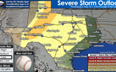
While the Storm Prediction Center has placed a Marginal (Level 1) risk of severe weather along the dryline today, development of any storms today looks to be low with a strong cap expected to remain in place. Nevertheless, if we can get one or two storms to develop…conditions are such that they could quickly become severe with a threat of large hail, frequent lightning and damaging wind gusts. Thankfully, the potential for tornadoes will remain low today. Our latest look at the short-range models indicate the most likely place for any storms to try to get going today will be south of the I-20 corridor and north of the I-10 corridor west of San Angelo where the cap may be weakest along the dryline later this afternoon. Even with that development, storms will struggle to maintain themselves and may die out quickly. Nevertheless, keep an eye out on the weather if you’re within or near the Marginal Risk zone this afternoon and have a way to get to shelter quickly should any severe weather develop and impact your immediate area.
Texas Weather: More Storms Heading Your Way Today And Friday!
Rowdy thunderstorms accompanied by heavy rainfall are set to persist until...


0 Comments