
Crashy, the cold front is on its way south this morning – moving through the Texas Panhandle and southern Oklahoma. One day I’ll have to explain the nickname ‘crashy the cold front,’ but not this morning. The cool front is being driven south by a surface low-pressure well to our northeast. We expect the cool front to continue pushing south quickly this morning. By 2 PM – it should be near San Angelo to Waxahachie to Clarksville.
The western half of Texas will remain ‘capped’ as the cold front moves south. Across the state’s eastern half, the cool front will encounter a very unstable airmass with a ‘breakable cap.’ Wind shear aloft will support organized thunderstorms. Luckily, low-level wind shear is modest and not supportive of a substantial tornado threat.
Severe Weather Outlook
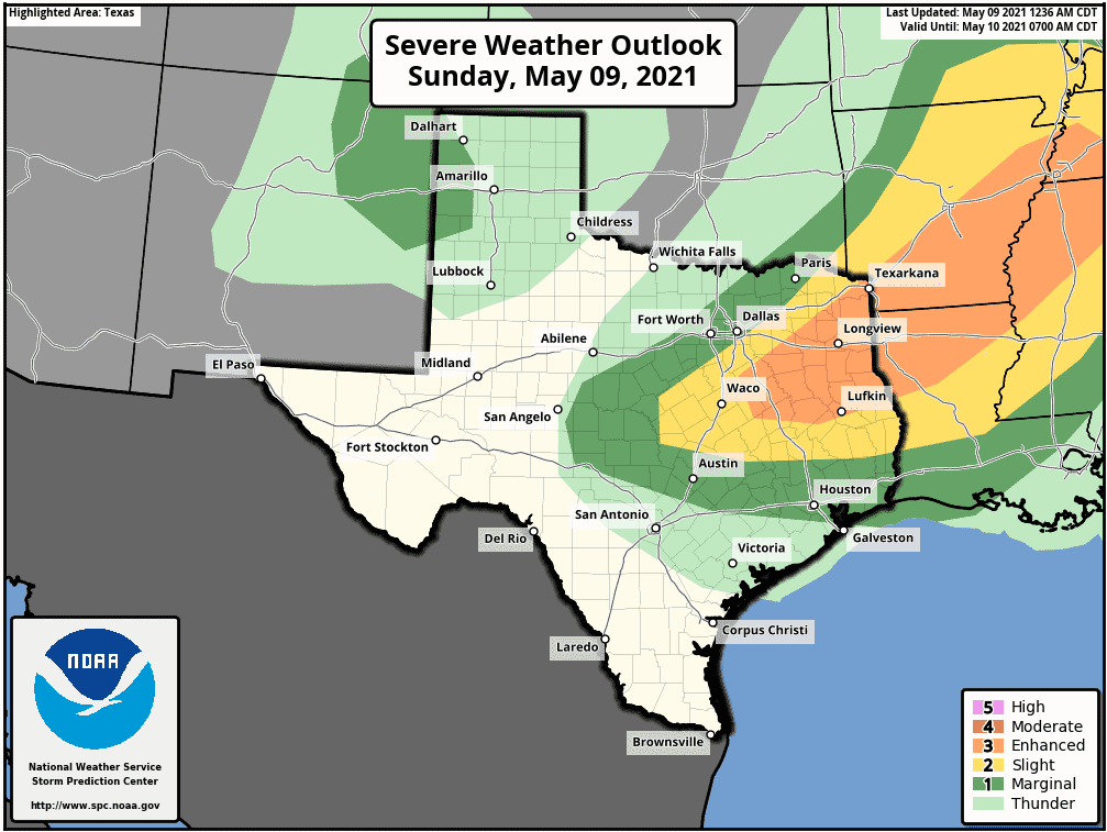
Severe weather outlooks are based on the probability of severe thunderstorms within one’s region. The higher a risk level – the higher chance a severe storm occurs in your area. For today, the Storm Prediction Center has introduced a level three out of five risk. That ‘enhanced’ risk includes southeast North Texas and portions of East Texas.
A level two out of five risk, the standard risk level, includes Central Texas, the northern Brazos Valey, snd southern North Texas. The lowest on the five-level scale, a level one risk, includes the eastern Concho Valley and Southeast Texas. A separate level one risk includes the far western Texas Panhandle, where high-based thunderstorms are possible late this afternoon.
Threats
With a very unstable airmass expected today, it will not be difficult to get hail production once storms develop. The most intense severe storms could produce very large hail up to the size of baseballs.
Most of the stronger storms will produce quarter to golf ball size hail. Damaging straight-line winds will also be a primary threat with stronger storms today. Some wind gusts could exceed 70 MPH, especially if a particularly nasty squall line materializes.
Today’s tornado risk is forecast to remain low. A tornado or two is certainly possible, but a lack of stronger low-level wind shear should prevent a more significant issue. Of course, if there is one tornado today and it comes down your street, it’s a pretty big problem.
Timing
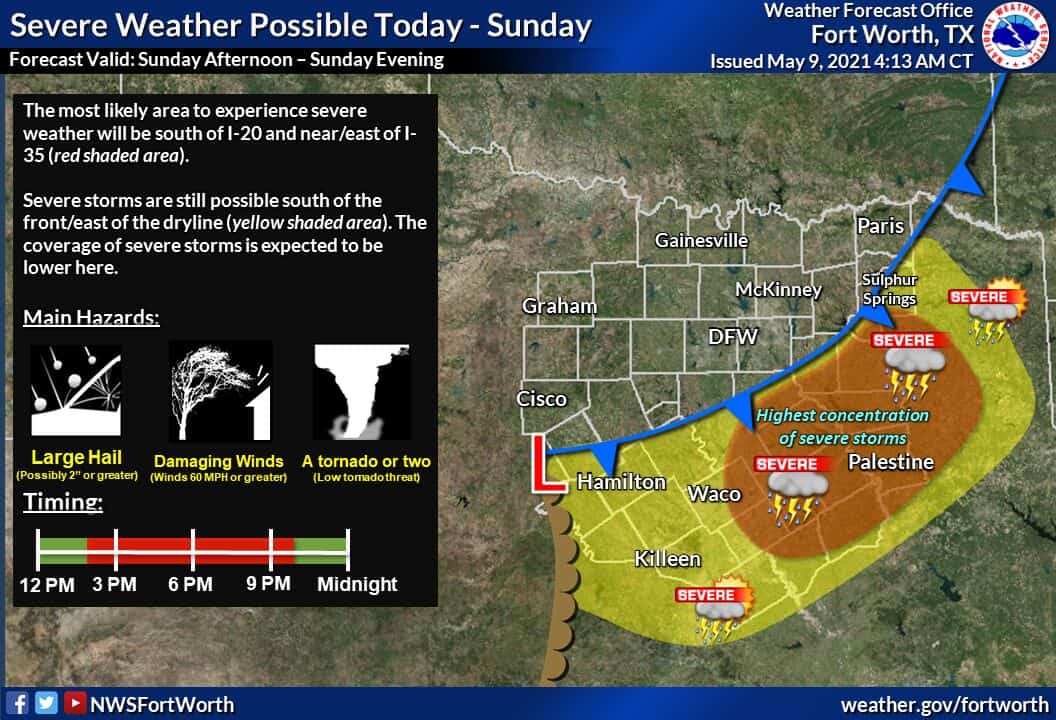
Initial thunderstorm development could begin by 1 PM just south of the cool front in southern North Texas and in East Texas. Thunderstorms should increase in both number and intensity in both regions this afternoon.
A small disclaimer: If storms fire up earlier or the cool front is a bit slower – we may see storms fire up closer to the D/FW Metroplex. As it stands now, the highest storm threat looks to be just south and east of D/FW. Storms will generally move to the east but will also sag southeastward with the cool front this evening.
By the late afternoon to around dinner-time, thunderstorms may start developing farther west into Central Texas along the cool front. Those storms could also be severe with large hail, damaging straight-line winds, and locally heavy rainfall.
Scattered thunderstorms will continue this evening in Central Texas, the Brazos Valley, and East Texas. Activity will slowly weaken by the mid-evening, though some stronger storms may continue past midnight.
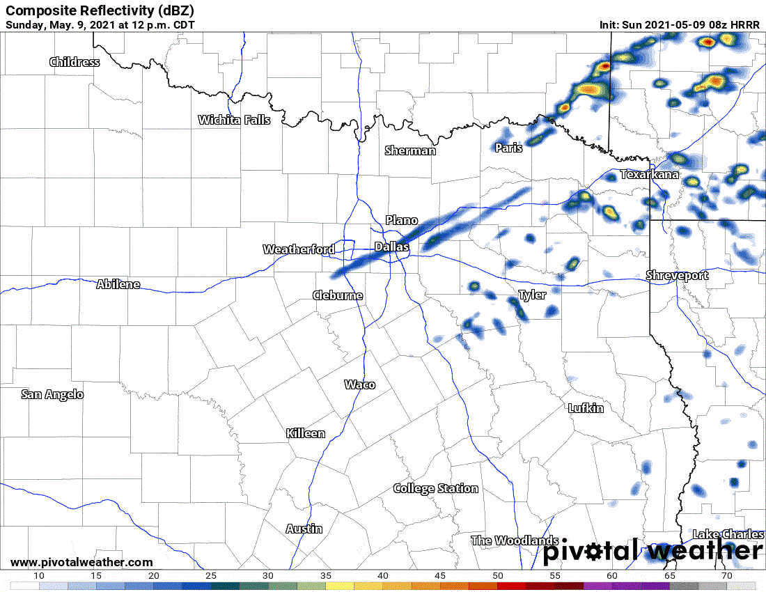
The high-resolution rapid refresh (HRRR) model does a decent job of showing the timing and approximate location of today’s thunderstorm forecast. Remember, this is a single weather model. Please don’t take it verbatim. We’ll have folks out chasing, and I’ll be providing digital severe weather coverage on our social media platforms.


0 Comments