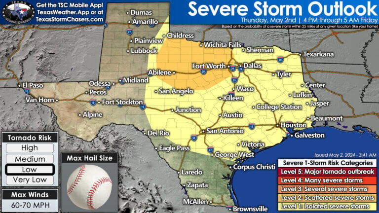
Rowdy thunderstorms accompanied by heavy rainfall are set to persist until early afternoon across the Brazos Valley, Southeast Texas, and the Golden Triangle. The threat of flooding due to excessive precipitation is a major concern, and this risk will persist even after the rain subsides, extending into the following week. Furthermore, there is a high likelihood of additional isolated to scattered thunderstorms developing off the dryline after 4 PM in Southwest Oklahoma, Northwest Texas, and the Big Country. This forecast indicates another prolonged evening and overnight period of thunderstorm vigilance.
Severe Storms This Evening into Friday Morning
Our next round of severe thunderstorm potential will (hopefully) be less widespread than yesterday, and will also be farther to the east. Today’s threat looks to begin after 4 PM in the Big Country, Northwest Texas, and into western Texoma. We’ll see isolated to widely scattered supercell thunderstorms develop east of the dryline. Those storms will likely become severe with a threat of very large hail, localized damaging wind gusts, and perhaps a few tornadoes as they slowly move southeast. Storms may also develop in Southwest and Central Oklahoma. Overall storm movement will be fairly slow (10-20 MPH) to the southeast.
This evening, thunderstorms will probably repeat last night’s upscale growth into one or more lines or complexes. Once the upscale growth occurs, we’ll see storms begin moving southeast more quickly into portions of Texoma, North Texas, down into Central Texas, Brazos Valley, and parts of East and Southeast Texas by Friday morning. We’ll need to see how the atmosphere recovers and shapes up this afternoon behind last night’s round of storms. That’ll dictate the eventual path of tonight’s storms. Regardless – localized damaging wind gusts, pocket-change size hail, and probably most impactful – more very heavy rain that could result in new flooding. Storms may continue into Friday across parts of the eastern half of Texas. Let’s get into this afternoon to see where all the ‘features’ are set up, and we’ll be able to refine the forecast for this evening through tomorrow.
Friday into the Weekend
Some thunderstorm threat is expected on Friday and Saturday as the dryline retreats back into western portions of Texas. Those storms, especially on Saturday, may move east as a complex into Sunday across the state’s northern half. Some storms may be on the strong side, especially during the afternoon hours. We’ll deal with tomorrow afternoon through Sunday once we get past today’s storm threat. Deal with one day at a time, and we’ll deal with the rest tomorrow. Unsettled weather is expected through the weekend. Some threats of severe, isolated storms may continue into Monday across Texoma and North Texas as a powerful storm system impacts the Central Plains.
Summer Weather Preview Next Week
A pattern switch next week may divide Texas. The northern half of Texas may remain in somewhat of an active weather pattern, with some chance for thunderstorms – though it looks lower than this week. The southern half of Texas will fall under the influence of the dreaded summer-time upper-level heat dome. That heat dome will establish itself over the Gulf Coast States, with enough of it falling over Texas to turn up the heat. High temperatures next week will top out in the 90s and 100s across the southern half of Texas, with 80s and 90s for the northern half. It’ll be hot, but the humidity will be atrocious across at least the eastern half of Texas. Heat index temperatures will likely be ten to twenty degrees above the air temperature, thanks to all the soil moisture from recent rains.
Helpful Links
Check out our current LIVE STREAM: https://texasweather.video/
Our FREE WEATHER APP: https://texasweather.app/
Our WEBSITE/RADAR: https://www.texasstormchasers.com
Our SOCIAL PLATFORMS: https://linktr.ee/texasstormchasers
Donations – [email protected]
*Enable 4K 60FPS when possible for best viewing results*


0 Comments