
What a fun week it is going to be in the world of Texas weather. I may not have much hair left on the top of my head, but whatever is left will probably be pulled out by week’s end. We’ll be dealing with a slow-moving, at times stationary cold front for the first half of this week. Temperatures north of the front will be pretty chilly with a shallow arctic airmass. The shallow cold front will meander back north and south over the next few days. Folks south of the cold front will enjoy temperatures you’d expect in early April. In other words, it’ll be toasty for February.
There will be a sharp temperature gradient in the vicinity of the cold front this week. It will not be difficult to find a temperature swing of thirty or more degrees over the span of thirty miles. Today, most of Texas will be on the ‘warm’ side with high temperatures in the 60s, 70s, and 80s. Tomorrow and Wednesday will probably feature the ‘cold side’ infiltrating Abilene, D/FW, and Paris. Patchy fog and mist will also be in the forecast on both sides of the front today and tomorrow.
The chance of showers and scattered thunderstorms will increase on Wednesday and Wednesday Night across the eastern two-thirds of Texas. Thunderstorm chances (as opposed to just showers) will be highest from Central Texas east into the Ark-La-Tex, East Texas, and Southeast Texas. A few storms may produce graupel or small hail, but severe weather isn’t likely.
On the opposite side of the spectrum, we will have to keep an eye out for freezing rain and/or sleet in Texoma and north of Interstate 20 in North Texas Wednesday Night and Thursday Morning. Significant impacts aren’t forecasted now, but if colder air can filter in more quickly, we might see some issues with bridges, overpasses, and elevated roadways. For now, this looks to be a case where precipitation moves out just before temperatures get cold enough to support accumulating winter precipitation.
Major Arctic Outbreak (finally) Arrives Saturday-Monday.
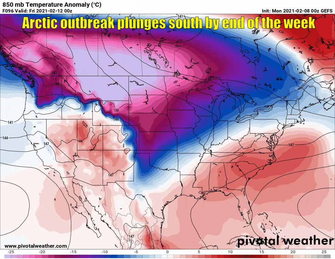
The American long-range model ensemble showing an arctic outbreak arriving this weekend in Texas.
Finally, after a week of procrastinating on its part, crashy the arctic cold front is likely to arrive this weekend. Frigid air has been bottled up across Canada and the Northern Plains. Wind chill values are near 50 degrees below zero west of Fargo. The virtual gates will swing open, and that cold air will come crashing south into Texas on Saturday.
Unlike the cold front today, this weekend’s front is going to come in with an attitude. Freezing temperatures are likely by Sunday morning along and north of Interstate 10. If those colder model solutions prove correct, the airmass on Sunday and Monday will be the coldest we’ve seen in several years across the northern half of Texas.
Will it snow this weekend or early next week?
It’s going to get cold, and it well may end up being extremely cold with bone-chilling wind chills. Yes, some winter precipitation may occur, but we are way too far out to speculate on amounts or specific locations. We’ll have to watch closely for a large chunk of Texas since anything that falls may be wintery. Weather models have been all over the place on the upcoming cold air event’s timing and strength, so check back this week for forecast updates.
Remember: Mama Nature doesn’t make winter weather forecasting easy in Texas, so use trust-worthy sources for weather information. Don’t assume everything you see on social media to be true.


0 Comments