
I hope y’all were able to get out and enjoy our spring weather across Texas today. Temperatures topped out in the 60s and 70s across Texas today. A strong cold front will begin pushing into the Texas Panhandle late tonight. By Thursday morning, the cold front will bring much colder temperatures to the entirety of Texas. Before folks start asking – no, we’re not talking about a repeat of last February.
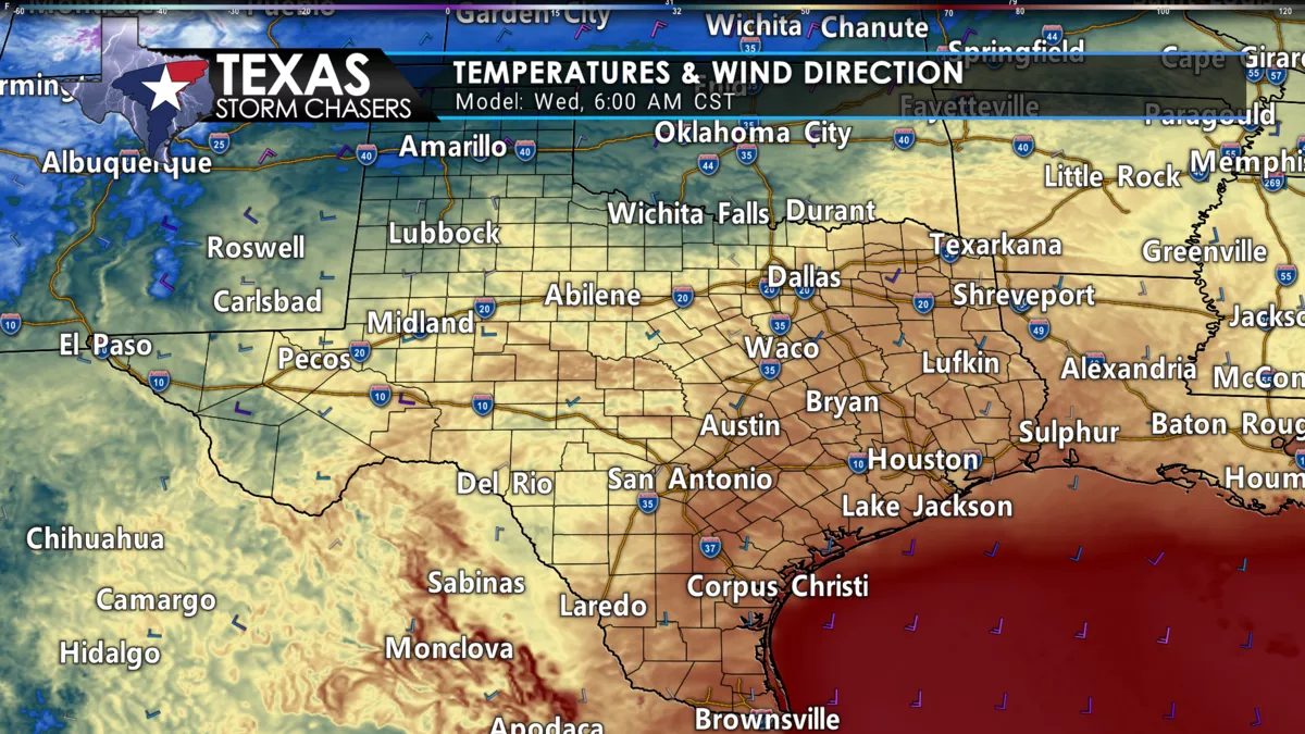
Crashy the cold front will make steady progress to the south on Wednesday. Temperatures behind the cold front will drop off into the 40s and 50s. We’ll see the ‘freezing line’ steadily progress south as well. We should see temperatures below freezing north of a line from near Del Rio to San Antonio to Tyler to Texarkana by Thursday morning. Weather models can be laggy with the cold air’s timing. Do not be surprised if the cold front ends up being a bit faster than what our timing graphic shows.
Unlike last week’s cold front, our upcoming ‘winter’ will last a few days. We’ll see overnight low temperatures drop below freezing for most folks nightly through the weekend. We are not talking about record cold temperatures, but it will be on the chilly side. Thursday should feature the coldest daytime high temperatures across Texas. By Friday and through the weekend, daytime high temperatures will start rebounding upwards. We are not anticipating multiple days of below-freezing temperatures. It’ll be chilly but not unusual for Texas in terms of winter cold snaps. The usual cold-weather tips will apply – including keeping your pets warm and securing outdoor water faucets.
Winter Weather Potential
There appear to be multiple opportunities for some winter precipitation Wednesday Night through Friday morning. These opportunities look to be low-end on the accumulation scale. Still, as we’ve seen, it doesn’t take much ice to turn elevated roadways into skating rinks.
Wednesday Night & Thursday Morning in the Panhandle
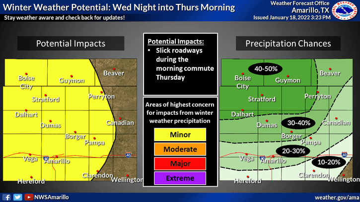
Light snow is possible across the Texas Panhandle Wednesday Night into Thursday Morning. The highest chance for snow and minor accumulations be across the western two-thirds of the Panhandle. At the time of this forecast, we’re thinking perhaps one-half to one inch of snow may accumulate in some areas. As always, we’ll have to watch for small-scale features that could locally enhance snow chances and amounts. We’ll look for those features in tonight’s weather model guidance and update the forecast tomorrow morning.
Thursday & Friday across the Southern Half of Texas
I’ll be honest with Y’all. Thursday and Friday will be a challenging forecast, and my confidence is definitely on the low side. After the cold air arrives late Wednesday and into Thursday morning, we’ll generally see temperatures remain steady or fall through Thursday and into Friday morning. We will see temperatures cold enough to support winter precipitation well into South Texas and Southeast Texas Thursday Night and Friday morning. That’s a higher-confidence aspect of the forecast. What is still up in the air are precipitation chances and overall amounts.
Thursday morning, we could see light ice accumulations across the Hill Country (southern Concho Valley into South-Central Texas). Ice accumulations would mainly be limited to elevated surfaces but could cause icy bridges – if we see precipitation.
Another upper-level disturbance is expected to pass across Southern Texas Thursday Night. Weather models are in poor agreement on the specifics, including the amount of moisture available, to generate precipitation. We know that temperatures at the surface will be near or below freezing across most of Texas, including into Deep South Texas and on the Texas Coast from Corpus Christi to Galveston. A mixed-bag of winter precipitation (rain, freezing rain, sleet, and perhaps some snow) could occur with minor accumulations possible. Ground temperatures are warm, so we anticipate most accumulations would be confined on elevated objects, possibly posing some issues for bridges and overpasses for the Friday morning commute.
Final Notes
I realize I’m not being particularly specific, but again, this isn’t something we’re confident about. We’re optimistic we’ll better grasp the potential for winter mischief with tonight’s incoming weather model data. I am confident we’ll see temperatures rise above freezing Friday afternoon. We are not anticipating long-duration accumulations or impacts (if any do occur). If we do have some impacts develop Thursday Night into Friday morning, they should quickly improve by Friday afternoon. We’ll have a detailed forecast update out tomorrow morning.


0 Comments