
It’s been a busy October in the severe thunderstorm department with multiple episodes of nocturnal squall lines. We’ve got another squall line episode setting up for tonight and tomorrow morning.
Quick Overview
Like the last couple of severe weather events, we’re expecting the show to get started around or a bit after sunset. The daylight hours today will be quiet in the severe weather department. The weather radar will be silent most of the day – until a line of storms rapidly develops this evening in Northwest Texas, the Big Country, and the Concho Valley. Those storms will move east overnight, Wednesday Morning, and continue until they exit Texas to the east a bit after lunchtime tomorrow.
The strongest storms will be capable of producing damaging straight-line winds, pocket-change size hail (dimes, pennies, quarters), and there is a low threat of brief tornadoes. Strong northwesterly winds will arrive after the storms, along with a cold front. Those strong winds will continue into Thursday and Friday.
Please take time today to ensure all outdoor yard decorations and loose objects are tied/staked down. Besides the strong winds with storms tonight, we’re expecting strong winds behind a cold front tomorrow, Thursday, and Friday.
Let’s get down to business and dive into the details of the storm setup.
Severe Weather Outlook
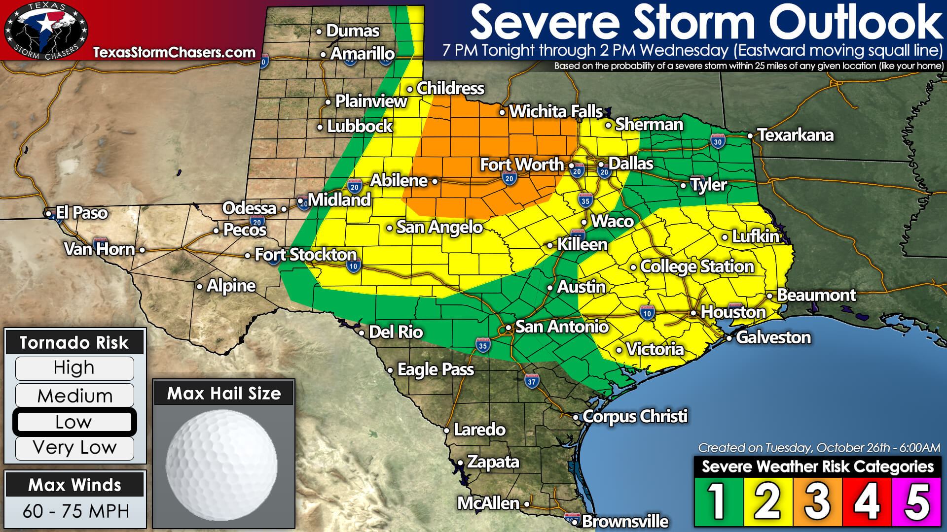
Click on the image for a full-size version.
Let’s start with the severe weather outlook for tonight and Wednesday morning. The Storm Prediction Center highlights a severe thunderstorm risk from the eastern Texas Panhandle southward into the eastern Permian Basin. That risk extends all the way east to the Ark-La-Tex and Louisiana tomorrow afternoon.
Another way to think about it is that the eastern seventy-five percent of Texas could see a strong or severe storm later tonight or sometime tomorrow morning. An exception will be folks south of a Del Rio to Corpus Christi line and in the western quarter of Texas. Everyone ‘not’ excluded from the risk zone should have a way to receive weather warnings overnight and tomorrow morning.
The highest probabilities of severe storms will be concentrated in Northwest Texas, the Big Country, and the western half of North Texas between 8 PM and 4 AM tonight. Mother Nature doesn’t read probability maps and any risk zone (whether it be the lowest or the highest) means a severe storm is possible in your neck of the woods. Learn more about severe weather outlook probabilities and the risk scale here.
The threat will begin around sunset in the western portion of the risk zone. A line of storms will move east tonight and tomorrow. Once the storms have moved east of your location, the threat of severe weather will be over. Not all storms will be intense or produce severe weather.
Initial thunderstorms may be supercelluar with a chance of producing damaging hail up to the size of baseballs. Hail sizes will come down after storms congeal into a squall line, but the threat for damaging winds will increase. A low tornado threat is expected with both discrete and linear storm modes tonight.
Thunderstorm Timing

Click the animation for a full-size version.
Storms will be approaching Interstate 35 from Texoma south to San Antonio (including D/FW, Waco, Temple, Austin, etc.) between 3 AM and 6 AM Wednesday. Some storms will be severe with damaging straight-line winds, hail, and a low threat of brief tornadoes.
We’re expecting storms to move into East Texas and the Brazos Valley between 5 AM and 8 AM. Those across Southeast Texas, including the Houston Metro, Far Northeast Texas, and the Piney Woods of East Texas, look like 7 AM to 11 AM Wednesday. Some storms will likely be severe with damaging straight-line winds, hail, and a threat of a brief tornado. After 10 AM, we may see some intensification of storms as daytime heating causes the atmosphere to destabilize.
Storms should be moving east and out of Texas around or a bit after noon tomorrow. Strong northwest winds, a much drier airmass, and a higher threat for grass fires will be underway across much of Texas tomorrow afternoon and again on Thursday.
Storm Chasing & Live Coverage Plans
We’ll have folks out tonight to document the line of storms as it moves east into North Texas. I’ll be in ‘TSC HQ’ and ready to provide live severe weather coverage tonight and tomorrow morning. Live video will be available on our YouTube channel and embedded within our weather blog (which is what you’re reading this post on now) and our free mobile app. Make sure you’ve bookmarked our interactive weather radar! I’ll also try to put a video briefing together after 8 AM.


0 Comments