
Another nocturnal and morning severe weather threat is looming as an intense upper-level storm system arrives Tuesday night and Wednesday morning. Like the previous events this month, we’re expecting most of the daytime Tuesday to remain quiet in the severe thunderstorm department.
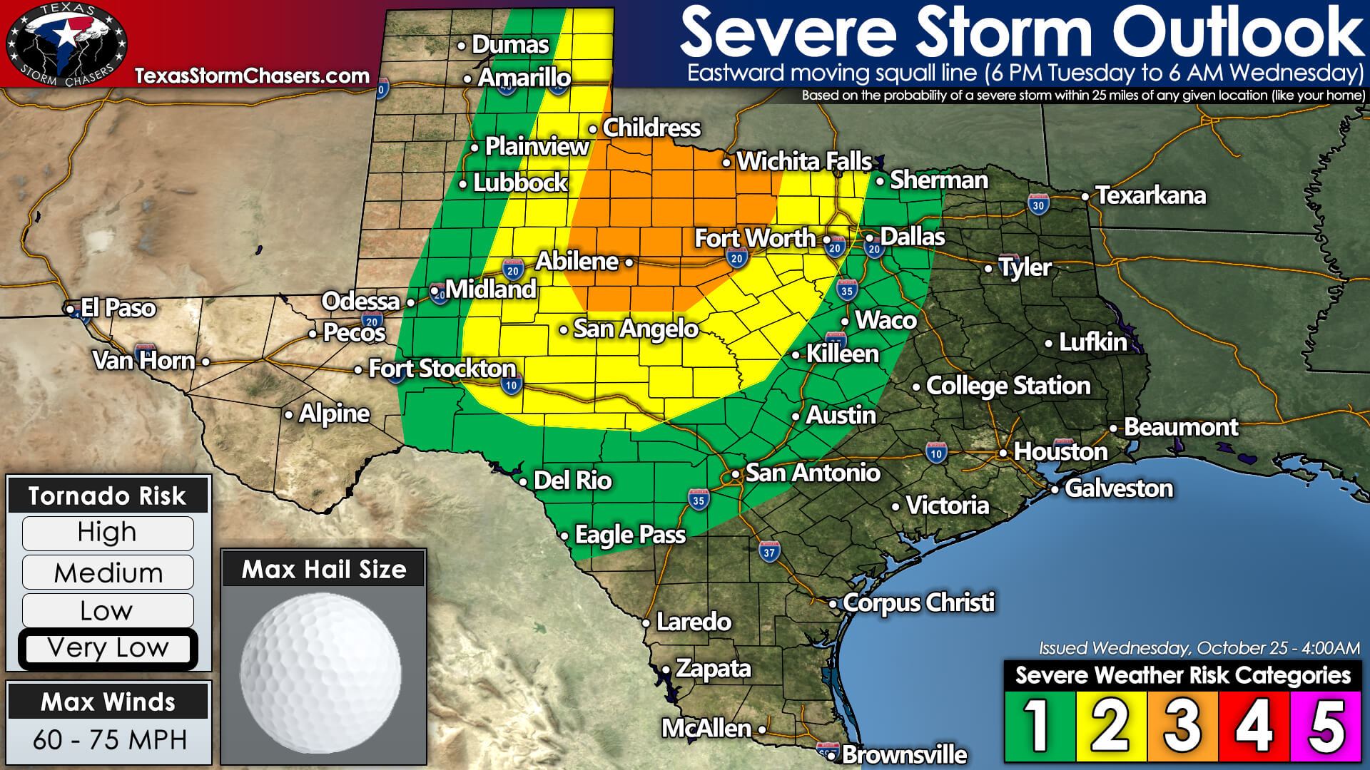
A severe weather threat is outlined from the eastern Texas Panhandle southward through West-Central Texas and the Permian Basin. The risk extends eastward through the Edwards Plateau, Hill Country, Central Texas, Big Country, Texoma, and North Texas. The risk will begin in the western zones around sunset Tuesday and continue into areas further east through sunrise on Wednesday.
We may see a severe thunderstorm threat persist into Wednesday morning and Wednesday afternoon across East Texas, the Brazos Valley, and Southeast Texas as daytime heating destabilize the atmosphere.

I’m not going to get into the various risk levels except to say any risk level means there is a chance for a severe storm in your vicinity Tuesday night and Wednesday morning. If you’d like a more detailed explanation of the severe weather outlook risk scale, we’ve got a detailed explanation here.
Timing & Threats

The quietness will change around sunset as discrete thunderstorms erupt in the eastern Texas Panhandle, southward into West-Central Texas and the Concho Valley. Thunderstorms will move to the east/northeast. The most intense discrete thunderstorms may produce golfball size hail, localized damaging winds, and perhaps a tornado.

A timeline and general progression of thunderstorms Tuesday night and Wednesday morning from the NWS Fort Worth.
We’re expecting a relatively rapid transition into a squall line by Tuesday evening. That squall line will move east and impact several regions of Texas overnight Tuesday and into the morning hours on Wednesday. Damaging straight-line winds and a low threat for brief tornadoes are likely with the most intense storms.
Quarter to ping-pong ball size hail can’t be ruled out with the most intense storms, but the hail threat will come down once storms are in a line versus out all by themselves. Storms are likely to move into the D/FW Metroplex between 2 AM and 5 AM (we’ll narrow down the timeframe later today when additional data arrives). The same thing goes for all areas in the risk zones, but we’re expecting an overnight event again.
Let’s not have folks getting fooled when the radar is still quiet at 5 PM tomorrow. The event itself won’t start ramping up until around sunset, perhaps an hour or two later in the Panhandle and West Texas.
Not all storms are going to be producing damaging winds or hail. We’ll be dealing with the squall line into the day on Wednesday as it moves into East Texas and Southeast Texas.
While the squall line is likely to weaken pre-dawn Wednesday, it may re-organize later in the morning and into the afternoon as it moves into East Texas and Southeast Texas. We’ll deal with that potential scenario later tonight or tomorrow – since we’ll also get a better idea of how tomorrow night will unfold too.
I’ll have another written update by this evening, along with a video briefing explaining our latest thoughts. Our busy October in the overnight squall line department continues. It’s no wonder I’m ‘Baldy-in-chief’ at the ripe age of 30.
Don’t forget to download our free mobile app to have our interactive weather radar right on your device!


0 Comments