
An impactful winter storm and much colder temperatures are headed to Texas for the second half of the workweek. Like I stated last night, this is not unusual during February in Texas, especially during La Nina winters. Even though we’ll still end the winter well above average in the temperature department, there will be intrusions of much colder air and the chance for winter precipitation if we can get the timing right. It looks like the timing will indeed ‘line up’ for parts of Texas on Wednesday and Thursday.
Winter Storm Watches will likely be issued for portions of the Texas Panhandle, West Texas, Big Country, Northwest Texas, Texoma, and North Texas this afternoon. They may already have been issued by the time you read this discussion.
I’m currently at 38,000 feet above Kentucky on my way back to Dallas from the Mid-Atlantic. With the timing constraints of landing in Dallas around 5 PM, I will push this discussion out a bit early. This evening, we’ll post a video discussion with the latest on any winter storm watches issued between this discussion and dinner-time.
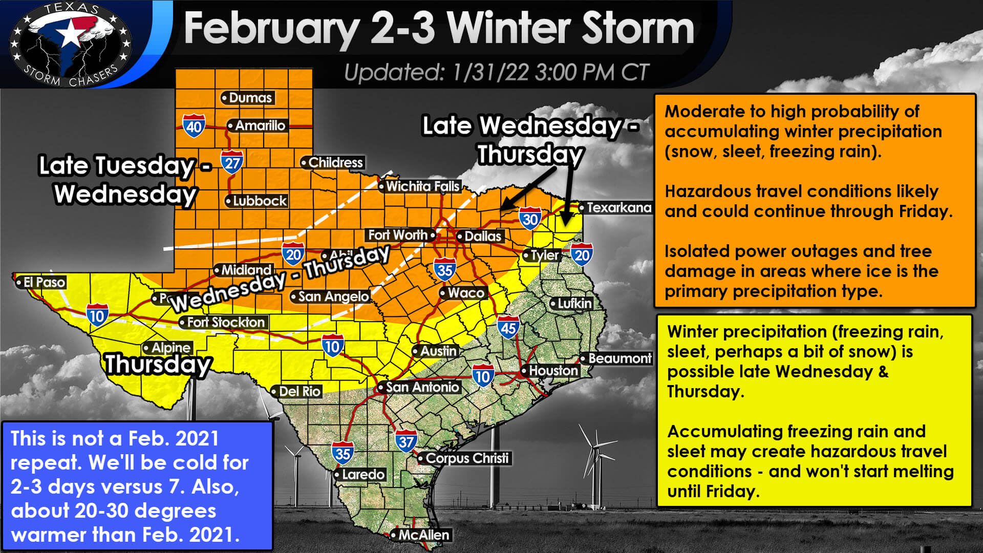
We’re starting to get a better idea of the overall expectation of precipitation types and accumulations. Unlike February 2021, or at least the last couple of events in that week of hell, we won’t be dealing with an all-snow event. We’ll have to deal with the trifecta of winter precipitation this time.
Freezing rain, sleet, and snow – not to mention ‘cold rain’ where surface temperatures are above freezing. Without going into the nerdiness of calculating winter accumulations – I’ll say that each precipitation type has a different ratio (compared to the liquid-equivalent of rain) for accumulations. Have multiple precipitation types occur in one location. You might see just how difficult trying to pin down a specific number will be.
The Texas Panhandle looks like it will be mostly snow – which will make that aspect of the forecast easier. Several inches of snow looks likely, but we’ll dive down deeper into numbers in a later update. A mix of freezing rain and sleet, perhaps changing over to snow, looks likely across Northwest Texas, Texoma, the Big Country, and North Texas.
There could be a nasty ice storm in there too for some folks – something we’ll have to carefully monitor given the increased probability of tree damage and power outages. Speaking of power outages, I’m only talking about power outages caused by ice accumulations on power lines or trees that fall on power lines. I know most of you are thinking ‘power outages’ like the kind experience during the week of hell last February – and those do not factor into our forecasts.
On Thursday, we may see some snow in the Borderland (El Paso) as temperatures drop below freezing. A winter mix of freezing rain and perhaps some sleet is expected across the Permian Basin, Trans-Pecos, Concho Valley, Hill Country, Central Texas, and maybe the Brazos Valley.
It doesn’t take much freezing rain or sleet to turn roads into skating rinks, so travel impacts are likely – even if overall amounts remain on the lighter side. This forecast aspect is a little less confident than further north, so we’ll be refining details in future updates.
For most folks, precipitation should be concluding late Thursday morning or Thursday afternoon. A few ‘hints’ in weather model data of a weaker upper-level storm system pushing across the Panhandle and Oklahoma later on Thursday. If that second system does materialize, we may see light snow continue much of the day across the Panhandle, Texoma, and north of the Red River.
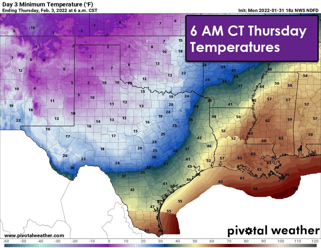
Temperatures will drop well below freezing across the northern two-thirds of Texas by Friday morning. Those with a snow or ice pack will likely fall into the single digits or lower teens. Wind chill values will be highly unpleasant.
These frigid temperatures will be problematic if we have power outages (either localized from ice, or I won’t even speculate on any other reason since it should be apparent to anyone around last February). However, temperatures will remain about twenty to thirty degrees higher than last February. We’re also going to start warming up on Saturday, with afternoon temperatures rising into the 40s.
We’re headed into a freezing weather pattern for the second half of this week. Still, it most definitely isn’t on par with last February in duration or intensity. Yet, hazardous weather is likely to bring significant impacts to portions of Texas over the coming days. Just because it won’t be ten below zero with a foot of snow on the ground doesn’t mean we shouldn’t make sure our pipes are wrapped or drained, pets are inside or in a warm shelter, and our neighbors and elderly folks are staying warm.
We’ll have a video discussion out later tonight along with a written update. I’ll also include some accumulations numbers, though I don’t want to get too hung up on them at this range. I’m more concerned about impacts versus the all-mighty ‘how much snow will I get’ game.


0 Comments