
A period of active weather, including cold temperatures and winter mischief, is expected to keep weather-folks busy in Texas this week. I would be surprised if you’ve managed to avoid chatter of the potential for winter mischief later this week. Before we dive into the details, let’s establish some key messages.
Texas Winter Weather Key Messages
- Much colder weather will arrive in Texas Tuesday Night into Wednesday Night. We’re likely to experience our most frigid weather of the winter on Thursday and Friday.
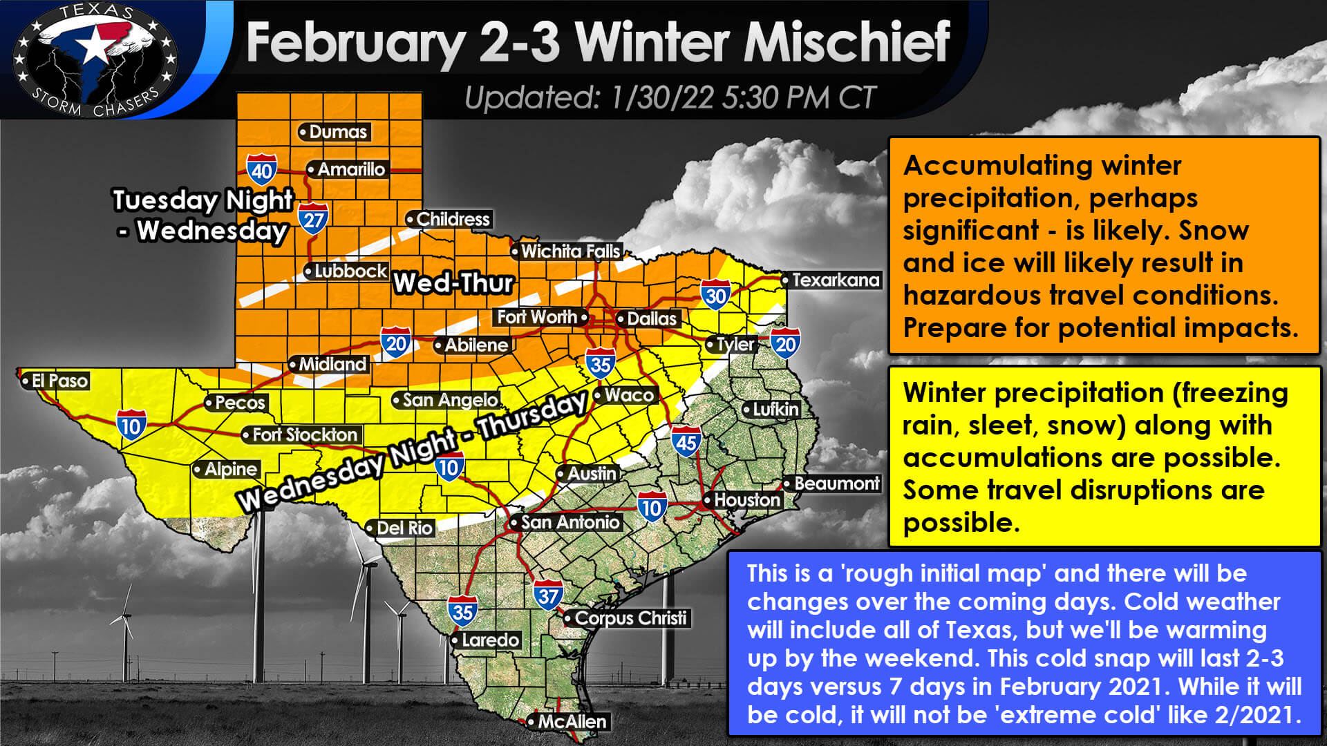
- Winter weather (freezing rain, sleet, and snow) is possible across the northern half of Texas – beginning Tuesday Night in the Panhandle and concluding on Thursday across the northern half of Texas.
- Accumulations of snow and ice are becoming more likely across the northern half of Texas on Wednesday and Thursday. Hazardous travel conditions are probable. Melting would not begin until Friday or Saturday.
- February 2021’s ‘week of hell’ lasted seven days. The upcoming cold snap will last 2 to 3 days – with warming temperatures this weekend. We’re also not expecting the extreme, record cold temperatures experienced last year – but it will be cold state-wide.
- Confidence in much colder temperatures later this week is high. Confidence in winter precipitation occurring in parts of Texas is high. Confidence in specific winter precipitation types and accumulations is low (northern half of Texas) to moderate (the northern third of Texas).
Since we’re still several days out from our winter weather threat, I will not go into specifics on accumulations. We’ll see accumulations greatly depend on the type of precipitation (snow, sleet, freezing rain) along with how long each precipitation type occurs at any given location. I’ve placed approximate start times for winter precipitation on the graphic above. We’re anticipating a start time of Tuesday Night for the Texas Panhandle and West Texas and Wednesday for the northern third of Texas. We might have some winter precipitation across the northern half of Texas Wednesday night and into the first half of Thursday.
I hope to provide our first accumulation map tomorrow afternoon. Regardless of accumulation numbers, I’m more concerned about giving an ‘impact map.’ We’ll also have to watch carefully where freezing rain may occur since that precipitation type has the highest threat of causing damage to trees and powerlines (if enough freezing rain falls).
That’s a whole other can of worms, but all winter precipitation types will likely cause travel disruptions where they accumulate. Sleet and snow would pose less of a threat to trees and powerlines but would still be quite impactful to travel. Long-time followers know we typically have a hard time predicting winter weather outside of a day or two in Texas.
Like last February and the 2011 winter storm, this upcoming event has several ‘synoptic’ features that allow for a long-range ‘heads up’ of an impactful winter weather event. The usual difficulties in determining specific accumulations and precipitation types remain. So, we can provide with some confidence a ‘early heads up’ that travel is going to become a problem – I can’t accurately say ‘from precisely what or how much.
Temperature Forecasts
Much colder temperatures will impact Texas from Wednesday onward through Saturday morning. We’ll start seeing daytime high temperatures climb above freezing on Saturday across Texas, but overnight low temperatures will still be cold. Friday Morning and perhaps Saturday Morning look to be the coldest across Texas – with the entire state below freezing. A hard freeze (temperatures below 10 degrees) to near 0 is possible north of a line from Alpine to Brownwood to the D/FW Metroplex to Paris Friday and Saturday mornings. While quite cold, those forecast temperatures are still 20-25 degrees above the February 2021 record lows.
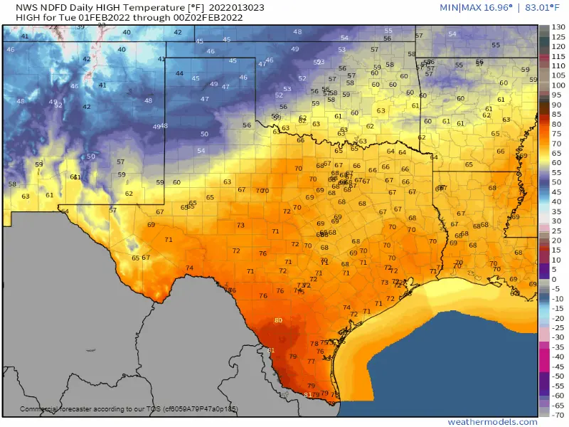
High-temperature forecast for Texas from Tuesday through Saturday.


0 Comments