
An impactful day so far with multiple tornado warnings and flash flooding across parts of Texas. The threat for brief tornadoes seems to be decreasing, but I hesitate to rule one out in North Texas through sunset. Today’s brief tornadoes were caused by a tropical-like setup versus a classic spring severe weather setup. Storms today have managed to drop nearly 14 inches of rain in portions of Jackson, Wharton, and Matagorda counties in Southeast Texas. Three to five inches of rain fell in Austin along with portions of Dallas.
This week’s weather forecast is both easy and difficult. I can confidently say most folks across the eastern two-thirds of Texas will see rain by Friday. The hard part of the forecast is determining the specific timing/location of heavier rains – and who may end up getting another eight to ten inches of rain. Today’s big-time rain totals certainly support the heavy rain threat as we go into the workweek. The highest chances for heavier rains and flooding will be Tuesday through Thursday across the eastern half of Texas. Rain chances do look to continue into Friday, and so may the threat for flooding.
Heavy Rain & Flooding
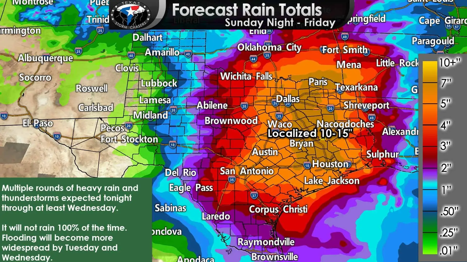
Most droughts typically end with a flood – and that’s certainly looking to be the case this week across the eastern half of Texas. Confidence is high that it will rain this week. We’re also confident someone will get too much rain, and that will result in flooding. Our confidence is lower on who will see the heaviest rains (10-15 inches). As today’s rains demonstrated, we can see 3-10+ inches of rain in a few hours if heavy storms move over a localized area. That same scenario will likely repeat itself multiple times this week.
On a widespread scale, three to nine inches of rain is forecast along and east of Highway 281 from Wichita Falls to San Antonio all the way to Louisiana and Arkansas. Localized amounts of ten to fifteen inches are possible, but that should be the high-end of things, and most folks won’t get to that extreme.
Flash flooding, including high water over roadways, creeks, and streams going out of their banks, along with significant river flooding, is expected to become more widespread on Tuesday, Wednesday, and Thursday.
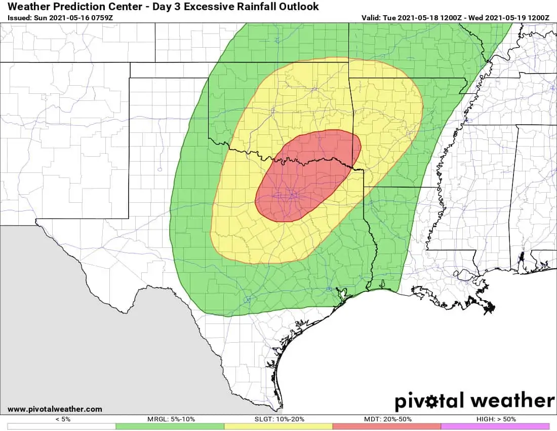
Flash flood outlook for Tuesday
There may be numerous roadways experiencing high water on Tuesday, Wednesday, and Thursday in multiple of our largest metropolitan areas. Some flooding may become life-threatening, especially in locations that receive 5-10 inches of rain in only a few hours (a few folks may experience this week).
Severe Weather Outlook
Monday & Monday Night
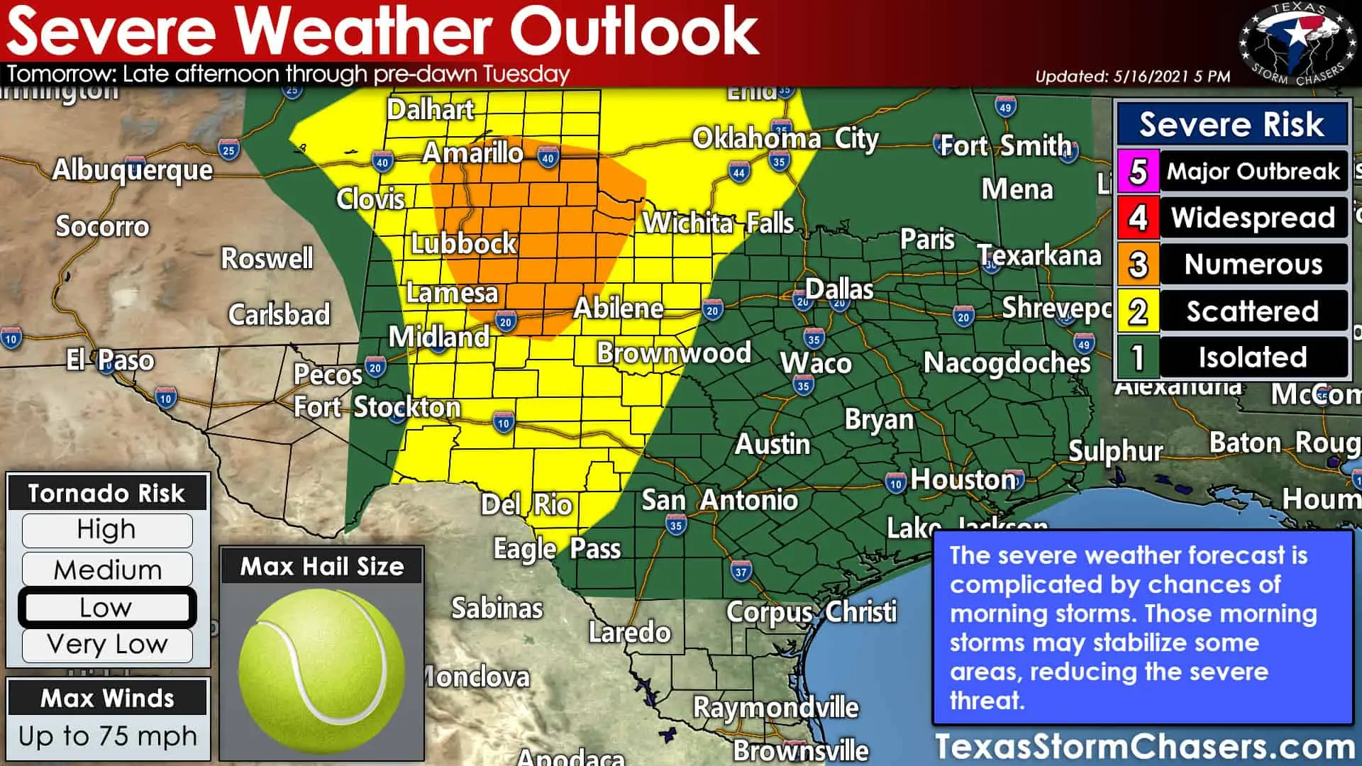
It may feel like a late-June weather pattern, but we are still in May. It wouldn’t be May without the risk for severe storms closer to the dryline in West Texas. That’s where the Storm Prediction Center has hoisted a level three out of five risk for severe storms Monday afternoon and Monday night. Risk levels are based on the coverage (or number) of severe storms. A level two risk includes Northwest Texas, the Big Country, Concho Valley, and Permian Basin. A level one severe weather risk for isolated stronger storms, includes everyone east of a line from Wichita Falls to Brownwood to Eagle Pass (the eastern half of Texas, north of South Texas). Click here for an explanation on the severe weather risk scale.
Stormy Chit-Chat
Tomorrow’s severe weather threat is complicated by the chance for morning storms. If those morning storms don’t move out in time, the risk for severe weather may be reduced in portions of the Panhandle and West Texas tomorrow afternoon. Likewise, if we have morning storms in the Panhandle, it is also possible they intensify as they move southeast toward North Texas – which would bring strong/severe storms into D/FW for the evening rush hour. We’ll monitor that possibility as new weather data arrives tonight.
As it stands now, we anticipate scattered severe thunderstorm development to occur east of the dryline around 4-5 PM. Initial storms will likely be supercelluar. The strongest supercells may produce very large hail, localized damaging wind gusts, and perhaps a few tornadoes.
The highest threat for a tornado looks to be in the level 3 risk zone. After several hours, storms across West Texas and the Panhandle should grow upscale into one or more thunderstorm complexes. Those storms would then propagate southeastward toward Oklahoma, Northwest Texas, the Big Country, and the Concho Valley with the threat of damaging straight-line winds, brief tornadoes, and hefty rainfall.
Given the uncertainties regarding tomorrow’s setup from the get-go – the last three paragraphs may be partially moot by morning. Regardless, damaging straight-line winds and flooding rains are the primary threats with any thunderstorm complexes tomorrow. Individual cells could produce large hail, localized damaging winds, a low-end tornado threat, and heavy rain.
Tuesday’s Severe Weather Outlook
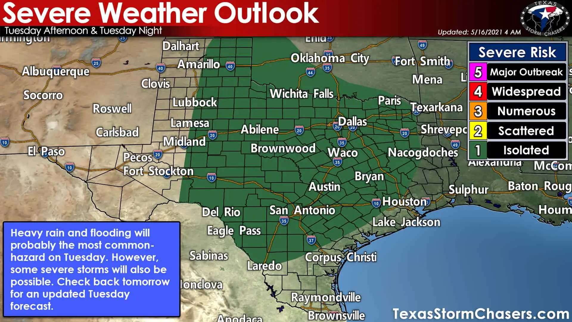
Some severe weather potential is also evident on Tuesday. Stronger storms could produce brief tornadoes, gusty winds, and small hail. We’ll try diving into Tuesday’s setup tomorrow to get a better idea of where various weather features will set up shop.
Finally…
This week’s weather setup involves tropical moisture and a very slow-moving upper-level storm system. Both of those factors combined with multiple chances of storms means an impactful week of Texas weather. I emphasize it won’t be raining 100% of the time. There will be dry stretches and some folks will probably be wondering what all the fuss is about later this week. We’ll have multiple chasers out this week – covering both severe storms and flooding. I’ll be in the office to provide digital weather coverage (which you can watch on our YouTube channel by clicking here or downloading our free mobile app).


0 Comments