
If you don’t like the weather just wait fifteen minutes. Three days ago the Texas Panhandle experienced a tornado outbreak. Late tonight, they’ll experience a blizzard. A Blizzard Warning is in effect beginning at 1 AM Wednesday north of a line from Hereford to Amarillo to Pampa to Higgins.
A Blizzard Warning means severe winter weather conditions are expected or occurring. Falling and blowing snow with strong winds are likely. This will lead to whiteout conditions, making travel extremely dangerous. Do not travel. If you must travel, have a winter survival kit with you and notify a friend or family of your plans. If you get stranded, stay in your vehicle.
Timing
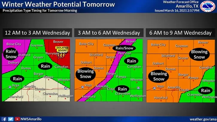
Timing of tomorrow’s blizzard in the Texas Panhandle
Severe thunderstorms are expected in the northeastern Texas Panhandle this evening. See our post on the severe weather threat for details. Rain will change over to snow around Boise City to Dalhart between midnight and 3 AM Wednesday. Thereafter, the rain/snow line will make steady progress east/southeast. By 9 AM, snow should be falling across most of the Panhandle. Snow will be heavy at times – which will overcome the melting process from warmer soil temperatures.
Accumulation Forecast
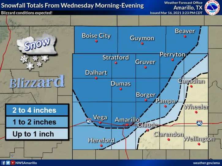
Forecast snow accumulations tomorrow in the Texas Panhandle
With the exception of the southeastern Panhandle, we expect one to four inches of snow to accumulate tomorrow morning and tomorrow afternoon. West/northwest winds will gust up to 60 MPH for most of Wednesday. Heavy snow combined with those severe winds will lead to blizzard conditions. Ground visibility will drop below a one-quarter mile and blowing snow will create hazardous driving conditions. Travel is strongly discouraged on Wednesday across much of the Texas Panhandle.
Some roads may be closed due to life-threatening winter conditions and/or vehicle accidents. Travel across the Texas Panhandle is also strongly discouraged tomorrow for commercial vehicles – including on Interstate 40 and Highway 287.
Snow will come to an end Wednesday afternoon, but hazardous travel will likely continue through Wednesday evening with gusty winds and sub-freezing temperatures continuing.
URGENT – WINTER WEATHER MESSAGE
National Weather Service Amarillo TX
421 PM CDT Tue Mar 16 2021
OKZ001>003-TXZ001>009-011>014-016-017-317-170530-
/O.UPG.KAMA.WS.A.0002.210317T0600Z-210318T0000Z/
/O.NEW.KAMA.BZ.W.0001.210317T0600Z-210318T0000Z/
Cimarron-Texas-Beaver-Dallam-Sherman-Hansford-Ochiltree-Lipscomb-
Hartley-Moore-Hutchinson-Roberts-Oldham-Potter-Carson-Gray-Deaf
Smith-Randall-Palo Duro Canyon-
Including the cities of Dalhart, Pampa, Gruver, Borger, Amarillo,
Perryton, Palo Duro Canyon, Panhandle, Boise City, Higgins,
Miami, White Deer, Vega, Booker, Hereford, Keyes, Spearman,
Channing, Forgan, Dumas, Canyon, Stratford, Follett, Beaver,
Hartley, and Guymon
421 PM CDT Tue Mar 16 2021
…BLIZZARD WARNING IN EFFECT FROM 1 AM TO 7 PM CDT WEDNESDAY…
* WHAT…Blizzard conditions expected. Total snow accumulations
between 1 to 4 inches. Winds gusting as high as 60 mph.
* WHERE…The Oklahoma Panhandle and northwestern two thirds of the
Texas Panhandle.
* WHEN…From 1 AM to 7 PM CDT Wednesday.
* IMPACTS…Visibilities may drop below 1/4 mile due to falling and
blowing snow. Whiteout conditions are expected and will make
travel treacherous and potentially life-threatening.


0 Comments