
Our weather across Texas today has been warm, dry, and windy. A nasty dust storm is underway near El Paso, and moisture is flowing north ahead of a potent upper-level storm system. A nocturnal severe weather threat is expected tonight and into the morning hours on Wednesday. Funny enough? Amarillo may see a few hailers this evening – followed by a blizzard and a few inches of snow about eight hours later. Yup, Mother Nature is throwing a tantrum. We’ll have a separate post on the Panhandle’s blizzard in a bit.
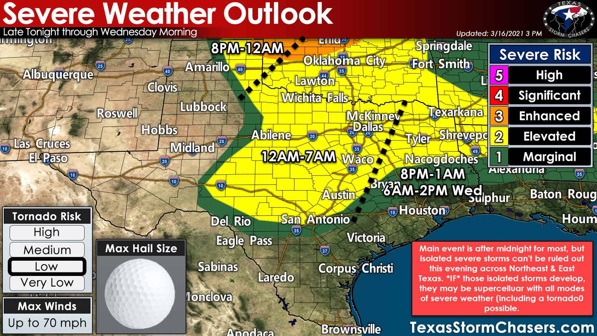
The Storm Prediction Center is highlighting a risk for severe thunderstorms tonight. Most of our severe weather threats will hold off until after midnight, with two possible exceptions. Not everyone in the risk zones will have severe weather. Any risk zone means there is a risk of a severe storm in your area tonight and Wednesday morning.
This Evening
The initial batch of storms will fire up in the eastern Texas Panhandle around or a bit after sunset. Those storms may produce very large hail, localized damaging wind gusts, and perhaps a tornado. We won’t have to deal with them for long as they’ll boogie east into Oklahoma.
Isolated severe thunderstorms are possible (not likely, but possible) across East Texas and Northeast Texas this evening. We’re talking a couple to a few storms if they’re able to form. They would be discrete, out by themselves, and in an environment quite supportive of severe weather. All modes of severe weather would be possible, including a tornado threat. One might refer to this as a ‘low probability, high impact scenario.
Main Show – After Midnight
A vast majority of the aforementioned regions will stay dry this evening. However, if someone ends up under one of the discrete storms, severe weather would be likely. This evening’s conditional threat would likely shift eastward into Louisiana and southwestern Arkansas not long after midnight.
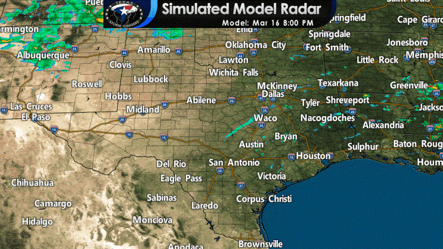
Simulated weather model radar this evening through Wednesday morning from the High-Resolution Rapid Refresh (HRRR) model.
Our ‘main event is expected to get going after midnight in Northwest Texas, the Big Country, and the Concho Valley. An eastward-moving dryline/cool front will spark off a broken line of thunderstorms. Once storms get going, the atmosphere will be favorable for severe weather. Large hail will be likely with the stronger storms along with damaging straight-line winds. The line of storms will quickly move east early tomorrow morning across North Texas, Central Texas, the Brazos Valley, and East Texas. Folks farther south may see a thin line of showers and storms, but a stronger cap should keep a lid on more intense storms.
Not all storms are going to be intense. Like a few days ago, some folks may not see more than a few showers with the cool front/dryline. Unlike a few days ago, we expect some severe storms to accompany the front until they push east of Texas early Wednesday afternoon. Low-level wind shear will be strong tonight and Wednesday morning.
Brief tornadoes will be possible within bowing segments of the squall line. Squall-line (or Quasi-Linear Convective System for weather nerds) tornadoes don’t usually stay down long, but can result in 90-115 MPH winds. If for some reason, we have any discrete supercells develop ahead (east) of the squall line, they would pose a more substantial tornado risk. That more substantial tornado threat looks to ramp up east of Texas tomorrow morning, but we’ll be watching.
Various Notes
Those in the Big Country, Concho Valley, Hill Country, and North Texas should be ready for strong to severe storms at some point pre-dawn Wednesday. Please have a way to receive weather warnings – whether it be a WEA (Wireless Emergency Alert) notification on your cell phone to a physical weather radio. We’ll be up all night and will be providing severe weather updates on our social media platforms. Keep an eye out for live video coverage as well (we’ll post any live coverage on our blog as well). Once the line of storms moves east of your location, the threat of severe weather is over. Strong west/northwest winds will occur much of Wednesday.


0 Comments