
Isolated to scattered thunderstorms are possible this afternoon and evening across the Big Country, North Texas, Central Texas, and the Brazos Valley. Like Sunday, but even more so today, minimal low-level moisture will put a lid on what could have been a significant severe thunderstorm threat. Tornadoes are unlikely, but frigid temperatures aloft will partially offset limited low-level moisture. It may not rain much with storms today, but they’ll be capable of putting out a copious amount of sonic nugget-ice size hail – and perhaps some not-so-small hail, too. The most intense storms may produce a LOT of hail and some hail stones up to the size of ping-pong balls. Keep tabs on storms with our free interactive weather radar.
I’m hopeful we can keep hail sizes small with storms this afternoon. Because of the dry low levels of the atmosphere, we’ll see plenty of evaporation with any rainfall. That process generates gusty winds, and localized damaging winds can’t be ruled out. I wouldn’t be surprised if some storms dropped more small hail than raindrops this afternoon. The best chance for stormy mischief will be between 4 PM and 11 PM. Storm motions will be to the southeast, with activity decreasing in both number and intensity a few hours after sunset. Once storms quit throwing out hail this evening, we’ll likely see several days of dry weather across Texas. Rainfall amounts will be minimal.
Big Warmup in time for Easter Day
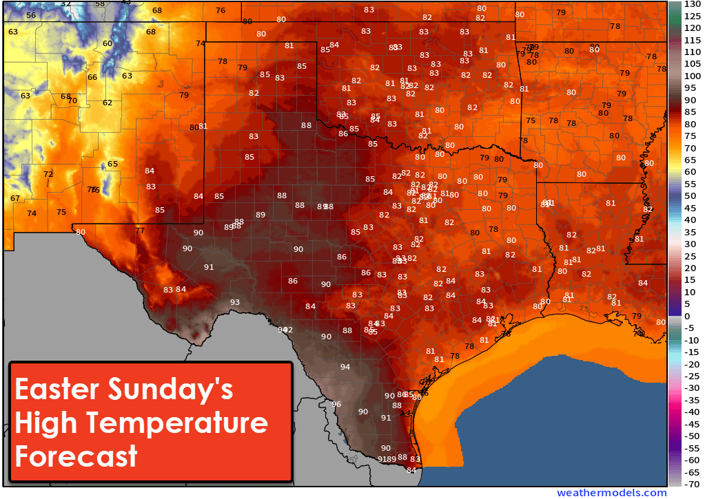
A significant warm-up is expected across Texas in the temperature department as we enter the second half of the week. You can get your local temperature forecast in the Texas Storm Chasers mobile app. By Easter Sunday, we anticipate high temperatures across Texas to be mainly in the 80s, or worse – not a tiny portion of the state may be in the 90s. Those hoping for an Easter Day cold snap will be sorely disappointed. Those attending outdoor activities should ensure plenty of sunscreen and be mindful that any candy may have a melting risk in the afternoon sun. It’ll feel more like late May than the final day of March. The eastern two-thirds of Texas will be humid, east of a surface dryline. The heat index temperature maybe a couple of degrees higher. Yay, heat index in March.
Next weather-maker arrives Monday
After today’s system, our next weathermaker looks to arrive on Monday. Unlike last Sunday and today, we will have several days of moisture return before Monday’s upper-level storm system arrives. Warm temperatures, plenty of moisture, and what looks to be an impressive upper-level storm system and cool front – all mean we need to watch the eastern half of Texas for strong to severe thunderstorm potential on Monday and Tuesday. Plenty of unanswered questions remain, and rowdy storm mischief is not guaranteed. However, we’re also in the time of year when such events become more likely. Weather models are hinting at that potential early next week. A decent cool down may occur across Texas after Monday’s storm system departs and pulls a cool front south.

0 Comments