
Scattered to several severe thunderstorms are likely late tonight into early Friday morning across West Texas, Northwest Texas, the Big Country, and Texoma. The late arrival of our upper-level storm system (and lift) has kept the cap in place across the dryline this afternoon in the Texas Panhandle and West Texas. An isolated severe storm can’t be ruled out in the northern Texas Panhandle through 9 PM. However, as the upper-level lift arrives, our main round of severe weather will begin after 10-11PM.
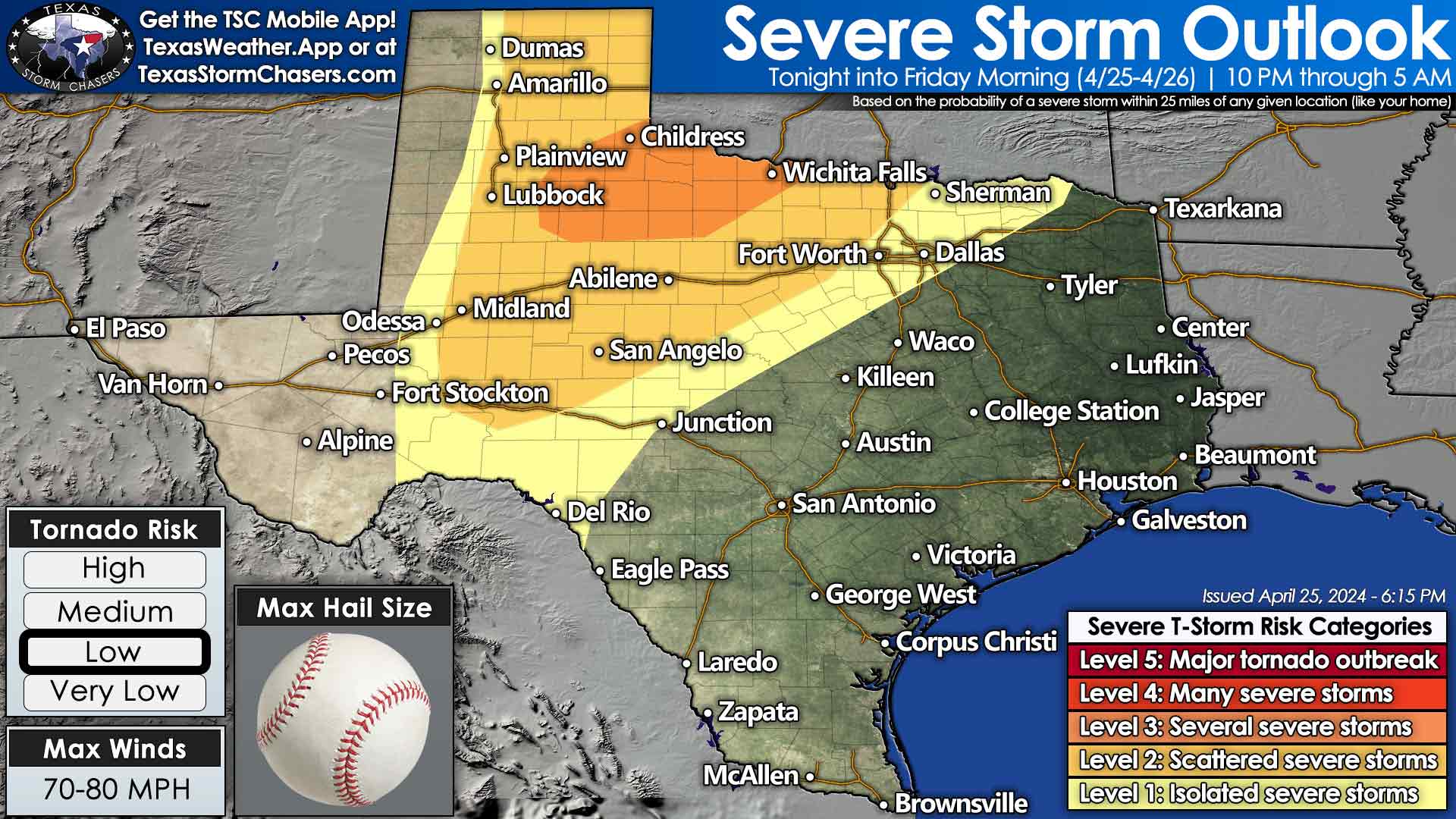
Ingredients will be in place late tonight into pre-dawn Friday to support severe thunderstorm potential in the abovementioned regions. The development will likely occur between 10 PM and 1 AM east of Interstate 27 in West Texas. Those storms will quickly become severe with large hail up to the size of baseballs, damaging wind gusts up to 80 MPH, and some tornado threat. Storms will congeal into a cluster or squall line that races east/northeast into the Big Country, Northwest Texas, and western Texoma by 3 AM. Severe weather (large hail, damaging winds, a few tornadoes) is likely with the most intense storms.
There are questions regarding the southward extent of the severe thunderstorm potential tonight. Some data suggests a line of storms will fire up into the Concho Valley and move east. Other data suggests the main round of storms will move northeast into southern Oklahoma. Regardless, storms that form will likely be strong to severe.
If the line of storms does move more easterly, it would move into North Texas after 3-4 AM, and impact Interstate 35 from the Red River south to the D/FW Metroplex during the morning rush hour with heavy rain, gusty winds, and perhaps some hail. Storms should weaken as they move toward Interstate 35 after 4 AM.
We may also see scattered showers and thunderstorms develop Friday morning across Texas, North Texas, and North Texas. Some storms may produce hail, gusty winds, and heavy rain.
Friday Afternoon
Some severe weather threats may exist in Northeast Texas late tomorrow morning, and we may see isolated severe storms develop in North Texas and Northeast Texas late tomorrow afternoon into early tomorrow evening. We’ll deal with the Friday afternoon, Saturday, and Sunday severe thunderstorms and flash flooding threats in Friday morning’s edition of the Texas Weather Roundup. You can keep an eye on the sky with the free interactive weather radar in the Texas Storm Chasers mobile app and on the Texas Storm Chasers website.
Helpful Links
Check out our LIVE STREAM: https://texasweather.video/
Our FREE WEATHER APP: https://texasweather.app/
Our WEBSITE/RADAR: https://www.texasstormchasers.com
Our SOCIAL PLATFORMS: https://linktr.ee/texasstormchasers
Donations – [email protected]
*Enable 4K 60FPS when possible for best viewing results*
A rowdy late evening and pre-dawn Friday is expected in the thunderstorm department across West-Central Texas, Big Country, Northwest Texas, into western Texoma. Keep an eye out for weather warnings overnight.
Hey!