
We’re in the midst of what could become a humanitarian crisis for some in Texas. Power outages are approaching four and a half million customers at the time of this writing. Low temperatures tonight will be brutally cold. I am sorry I can’t provide better news. Another winter storm will begin ramping up tomorrow afternoon. By Wednesday morning, we expect widespread accumulating winter precipitation across Central Texas, the Brazos Valley, North Texas, Texoma, Northeast Texas, and East Texas. In other words, more snow and a lot more ice.
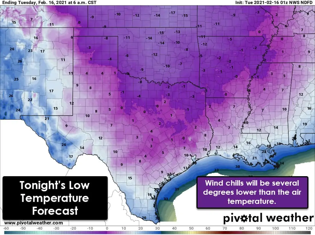
Low temperatures are forecast to drop below zero tonight across the Texas Panhandle, Northwest Texas, North Texas, and Northeast Texas. A good benchmark for such cold weather is the outbreak from December 1989. Temperatures will drop into the single digits as far south as Victoria and Houston. Corpus Christi will dive to 16 degrees with 26 degrees in McAllen. Some folks may be a few degrees warmer than they were last night. Frankly, it is still going to be bone-chilling cold, and we’ve got significant problems considering the state of our power grid. Wind chills will be five to ten degrees lower than the air temperature.
Another Winter Storm Begins Tomorrow Afternoon
Accumulating snow is forecast tomorrow afternoon in the Texa Panhandle and West Texas. For most of Texas, the show will begin tomorrow night and continue into Wednesday. Accumulating freezing rain, sleet, and snow are expected. In terms of snowfall, the highest amounts are likely to be north of Interstate 20 in North Texas and Northeast Texas. Unlike yesterday’s system, we’re going to have more of a ‘mixed bag’ of precipitation. Unfortunately, that means we may have an ice storm in portions of southern North Texas, Central Texas, the Brazos Valley, Southeast Texas, and East Texas. Temperatures on Wednesday will warm some, so the freezing line will slowly move inland from the coast. It looks like we may be done with most accumulating precipitation by Wednesday night, but impacts would continue into Thursday. Little melting from yesterday’s winter storm is likely before this new round arrives.
After the winter storm departs late Wednesday or early Thursday, we’ll be done with winter precipitation. A warming trend starts Thursday and Friday. We note it may take several days before the snow-pack can meltdown to where it won’t impact temperature forecasts. Those with a significant snowpack may have to deal with several days of colder weather with nearby areas with no snow experience temperatures 20+ degrees warmer.


0 Comments