
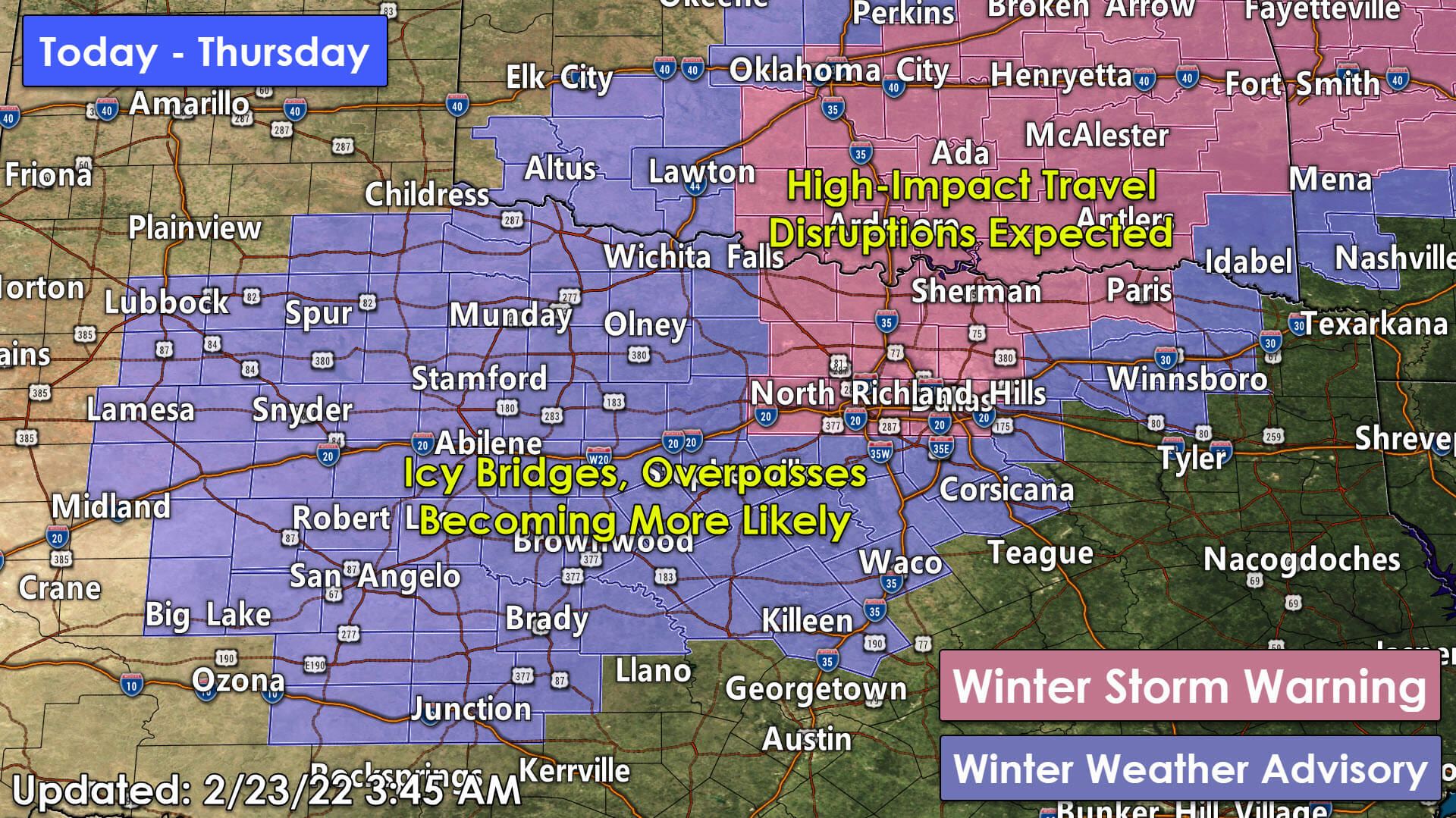
Overnight data has trended toward heavier freezing rain and freezing drizzle later today, tonight, and Thursday for portions of Texoma and North Texas. As such, the winter weather advisory has been UPGRADED to a Winter Storm Warning for the D/FW Metroplex, north to Sherman, Gainesville, and Paris. High-impact travel disruptions, especially for elevated roadways, are becoming likely.
Surface roadways may also become slick and hazardous, especially where temperatures fall into the 20s or where we have heavy sleet bursts. I’ll have a far more detailed discussion and forecast for the entirety of the state in a couple of hours.
Advertisements
Montague-Cooke-Grayson-Fannin-Lamar-Wise-Denton-Collin-Parker-
Tarrant-Dallas-Rockwall-
Including the cities of Bowie, Nocona, Gainesville, Sherman,
Denison, Bonham, Paris, Decatur, Bridgeport, Carrollton, Denton,
Lewisville, Flower Mound, Plano, McKinney, Allen, Frisco,
Weatherford, Briar, Fort Worth, Arlington, Dallas, Rockwall,
and Heath
326 AM CST Wed Feb 23 2022

...WINTER STORM WARNING IN EFFECT UNTIL 6 PM CST THURSDAY...

* WHAT...Periods of light freezing rain and freezing drizzle. Some
  sleet possible in thunderstorms. Ice accumulations of one-tenth
  to one-quarter of an inch. Sleet accumulations up to one-tenth
  of an inch. Conditions will deteriorate late tonight into
  Thursday morning.

* WHERE...From the Metroplex north to the Red River.

* WHEN...Now until 6 PM CST Thursday.

* IMPACTS...Elevated roads and bridges may become ice covered
  making travel dangerous. I-35 from the Metroplex to the Red
  River will likely have dangerous icy spots. Tree damage and
  power outages will be possible due to ice.


PRECAUTIONARY/PREPAREDNESS ACTIONS...

If you must travel, keep an extra flashlight, food, and water in
your vehicle in case of an emergency.

The latest road conditions for Texas can be found at
drivetexas.org.

0 Comments