
Tuesday proved to be a volatile day for wildfires across Texas. The Texas A&M Forest Service responded to two dozen requests for assistance by local fire departments on wildfires. Those requests were just for the more significant fires. There were likely many more that local responders handled in their infancy. Several fires were started by folks welding, so we want to encourage folks to be super careful if using outdoor equipment that could ignite the dry grass. We’ll be windy again today, so embers could go flying.
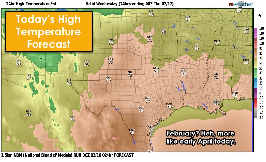
We’re in for another April-like afternoon in the temperature department. This afternoon, we’ll see high temperatures climb into the upper 60s, 70s, and even 80s. Achieving those temperatures isn’t so difficult when we only got down into the upper 50s and 60s overnight – which, ironically, is about where our high temperatures should be in mid-February.
More Wildfires Likely Today
We’re expecting another active day in the wildfire department across Texas. Even with higher humidity values, we’ll still see a moderate to high threat for fast-moving grass fires. You can thank dormant winter grasses, the ongoing drought, strong winds, and the ‘spring-like temperatures.’ The most heightened threat for wildfires, including the chance for a significant fire, will be across the Borderland (El Paso), the Guadalupe and Davis Mountains, the Trans-Pecos, West Texas, and the Texas Panhandle.
Windy with Blowing Dust in Far West Texas
Today, very strong winds over 55 miles per hour are expected across Far West Texas, the Borderland, and the Guadalupe and Davis Mountains. With the strong winds will come blowing dust and reduced visibilities. Travel may become difficult for high-profile vehicles, and everyone where we see half of a field goes airborne in a cloud of dust.
Severe Storms Late Tonight in Texoma
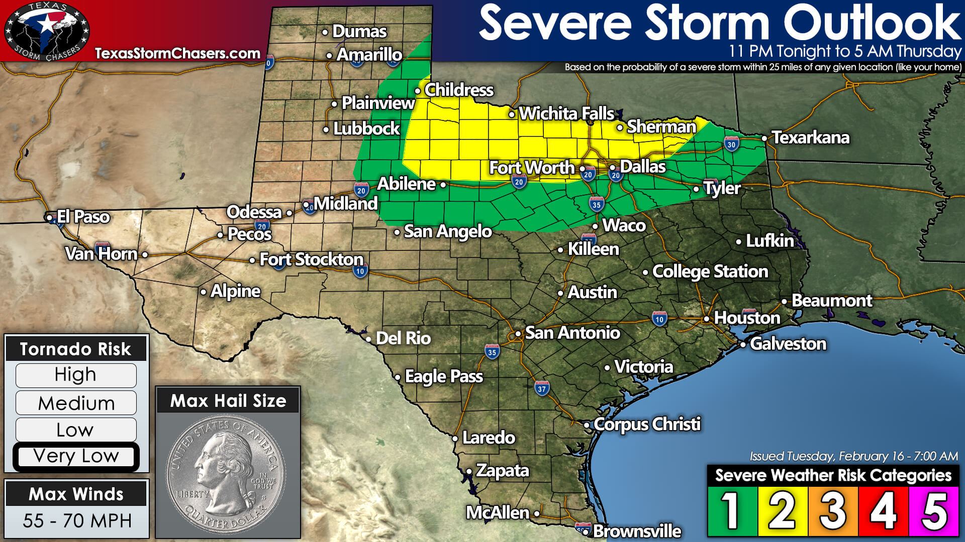
The Storm Prediction Center continues to highlight a risk for a few severe thunderstorms late tonight and Thursday morning. A line of showers and thunderstorms will move east across Northwest Texas, Texoma, and North Texas late tonight and early Thursday morning. Some storms may be severe, predominantly north of Interstate 20 and closer to the Red River in Northwest Texas and Texoma.
The most intense storms could produce large hail and localized damaging winds. A tornado cannot be ruled out, but the overall tornado threat is questionable. Suppose we end up being a bit more unstable. In that case, there could be a slightly increased tornado threat early Thursday morning in Texoma as storms move east into the region.
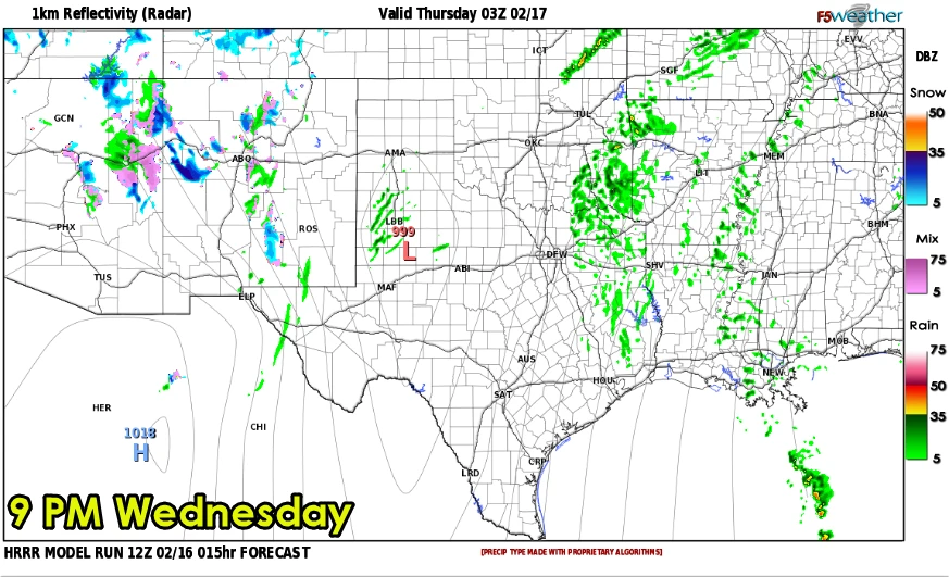
Simulated weather model radar from the High-Resolution Rapid Refresh (HRRR) model. This is only one model’s guesstimate, so don’t take it to the bank and try and cash it out.
Thunderstorms are not expected to develop until late this evening along an eastward-moving dryline in Northwest Texas. Once storms develop, they should quickly grow upscale into a squall line. The line of storms will move east early Thursday morning across Northwest Texas, Texoma, and eventually into North Texas. As the line of storms approaches Interstate 35 tomorrow morning around sunrise, they’ll be moving into a less unstable airmass.
Frankly, the line of storms may not be more than a quick burst of heavy rain and gusty winds by that point. This morning’s data indicates the highest relative threat for a few severe storms will be late tonight, probably from around midnight through 3 AM, across Northwest Texas and Texoma – including the Wichita Falls area.
Storms may and hopefully will be weakening as they move east into North Texas after that as the atmosphere starts to become less unstable. However, wind shear values will remain relatively strong, so we’ll have to keep an eye out just in case the storms find a little extra fuel.
Thursday Morning Snow
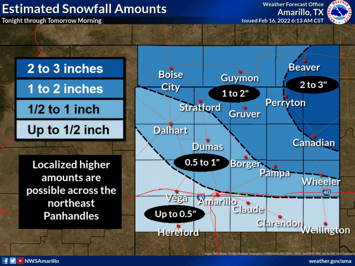
Temperatures will fall quickly tonight across the Texas Panhandle as crashy the cold front swings in on the back-side of the storm system. An area of precipitation will likely change over to snow. We’re anticipating a few hours of moderate to perhaps heavy snow across the northeastern Texas Panhandle Thursday morning.
Strong northwest winds up to 50 miles per hour may create near-blizzard conditions. Snowfall accumulations of one to three inches are possible north of Interstate 40 and east of Highway 287. The far northeastern Texas Panhandle – Perryton to Canadian and east into Northwest Oklahoma – may be overachievers in the snow department and could see localized amounts exceeding five inches.
Regardless, strong winds will create blowing snow, snowdrifts, and near-blizzard conditions Thursday morning across the northeastern Texas Panhandle. Snow will exit the Texas Panhandle tomorrow afternoon, but gusty winds may keep the snow blowing around for a while.
Colder, but only for a day or two.
We’ll see a cold front push south through a good chunk of Texas on Thursday into Friday morning. Cooler temperatures will result on Thursday, but we’ll start warming back up quickly as we get into the weekend. Above-average temperatures return to Texas for the weekend and early next week. There are indications in long-range weather model guidance of a general unsettled pattern by Wednesday – with the potential for a significant cold front and winter mischief. Time will tell what Mother Nature has in store for us, but we need the moisture.


0 Comments