
Active weather in the sense of multiple hazards will return to Texas today and tonight. While we’ve been dealing with increased wildfire danger for the last several weeks, we’ll get to throw in the chance for thunderstorms by tonight. Today will also be a potentially dangerous wildfire day, especially across the western third of Texas. Wind gusts up to 70 miles per hour, near record-high temperatures, and drought-stressed fuels will set the stage for a potential wildfire outbreak.
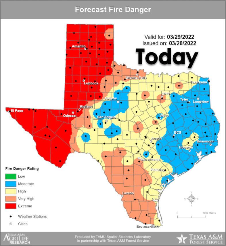
The Texas Forest Service has placed an extreme risk for fire danger across the western third of Texas today. This includes major population centers such as El Paso, Fort Stockton, Alpine, Odessa, Midland, Lubbock, Childress, Amarillo, and Dalhart. Any new starts or ongoing fires that escape containment lines can become large, significant wildfires. Today is a day when we could see the fires move 10-20 miles.
Today’s westerly winds will shift to the north tonight as a cool front moves south and east. The 90-degree wind shift (west to north) will result in dangerous fire behavior as strong winds continue tonight. High to very high wildfire danger will exist further east into South Texas and up Interstate 35 into Oklahoma. Even though relative humidity values will be much higher, drought-stressed fuels and strong south winds will overcome and negate the higher humidity. Until we get big rains that jump-start the spring green-up, we will have a bad fire season continue unabated. Widespread blowing dust is expected across Western Texas today. That dust, combined with smoke from wildfires, will probably make its way east tonight.
Tonight’s Thunderstorm Chances
Severe weather outlooks issued by the Storm Prediction Center utilize a five-level risk scale. Each risk level is based on the probability of severe storms within twenty-five miles of any given point, such as your location. A level one risk is the lowest and means isolated/short-lived severe storms are possible. A level five risk is the highest, is quite rare, and indicates a significant tornado outbreak or derecho is likely.
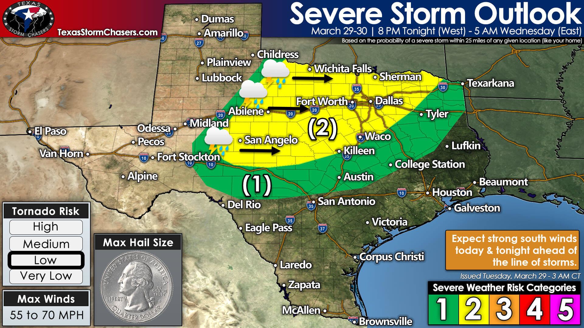
A level two out of five risk of severe storms has been outlined across Northwest Texas, the Big Country, the Concho Valley, Texoma, and North Texas. A level one out of five risk of severe storms extends further south and east, including the Hill Country, Central Texas, the Brazos Valley, and East Texas. The primary threats are localized damaging straight-line winds up to 70 miles per hour and brief tornadoes. A few storms may produce pocket-change size hail.
Most storms will produce wind gusts of 35 to 55 miles per hour. We note that winds up to 50 miles per hour out of the south may occur tonight across the eastern two-thirds of Texas. Those strong winds will not be related to thunderstorms, so that it will be windy regardless.
Timing & Threats
Thunderstorm chances will increase after sunset as an upper-level lift arrives near the dryline. The first storms of the day should fire up between 7 PM and 8:30 PM in Northwest Texas, the Big Country, and into the Concho Valley. Individual storms will move northeast, but we expect a nearly solid line of storms to develop quickly. The line of storms will move east at 30 to 45 miles per hour tonight and Wednesday morning. Strong to severe storms are possible with damaging straight-line winds and brief tornadoes.
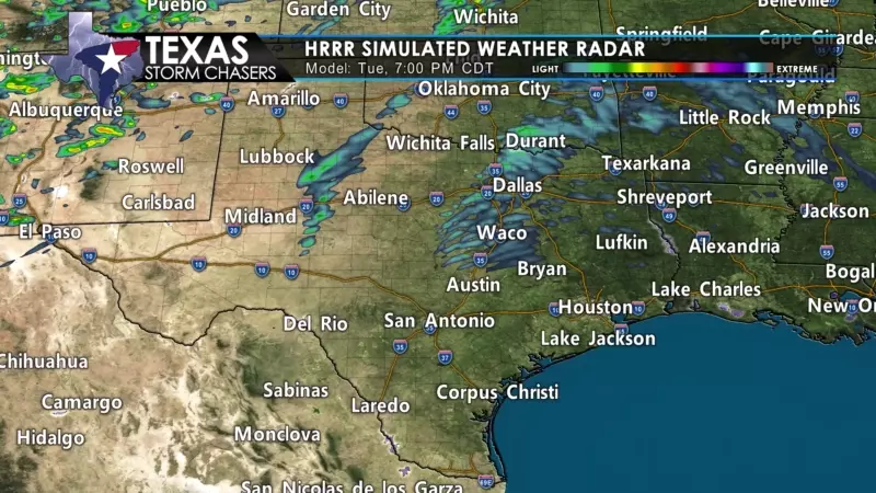
Initial storms may contain large hail, but the threat of large hail will diminish as storms become linear (form into a squall line). Most of the squall line will produce gusty west winds of 35 to 55 miles per hour. Stronger storms, however, may produce localized damaging wind gusts up to 70 miles per hour, along with brief tornadoes. Unlike last Monday’s discrete storms, tonight’s storm mode will strongly favor a thin squall line.
We’re mainly concerned with brief spin-up tornadoes and damaging straight-line winds with stronger storms in the line. We’d be more concerned with a longer-lived tornado threat if we had discrete storms tonight. Fortunately, a squall line looks far more likely – and the line itself may struggle at times with organization.
Storms will arrive on Interstate 35 from the Red River to the D/FW Metroplex around 2 AM, Waco to Austin around 3-4 AM, Tyler to Bryan/College Station around 6-7 AM, and Marshall to Houston between 8 AM and 9 AM. Stratiform showers and thunderstorms will continue for a couple of hours behind the squall line.
Precipitation chances will end by early afternoon as storms exit Texas to the east. Gusty northwest winds will arrive as a cooler, drier airmass pushes in behind the storms on Wednesday. Some folks may be lucky enough to get one inch of rain from tonight’s storm. It won’t be a drought buster, but hopefully, we may see a little green-up occur.
Wednesday’s Wildfire Danger
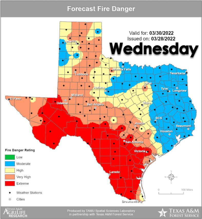
Another significant wildfire event is possible on Wednesday. Tomorrow’s highest risk of wildfires will be focused across the Borderland, Guadalupe & Davis Mountains, Concho Valley, Edwards Plateau, Hill Country, Central Texas, Coastal Plains, Coastal Bend, and all of South Texas. Like today, we may see significant/large fires occur – with the largest fires burning several thousand to tens of thousands of acres.


0 Comments