
Our next upper-level storm system will bring a multi-facet weather hazard event on Tuesday, Tuesday Night, into Wednesday morning. Let’s be clear that we’re not looking at a repeat of last Monday at the get-go. Yes, we’ll have the opportunity for stronger thunderstorms. No, we are not expecting another tornado outbreak or a plethora of longer-lived, significant tornadoes.
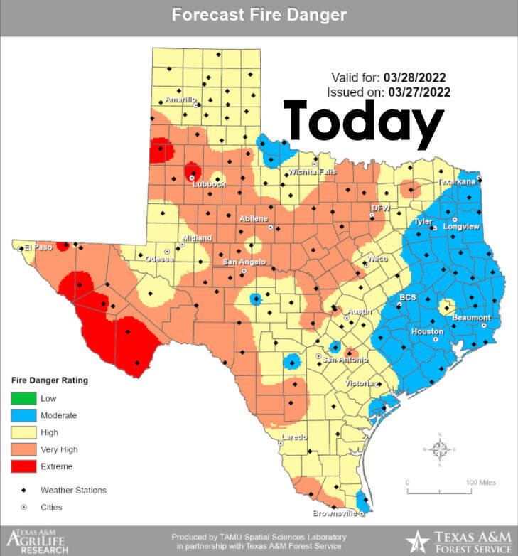
Today’s weather hazards will continue to focus on the heightened wildfire risk across Texas. High to very high wildfire danger will continue across the western seventy-five percent of Texas today. Multiple ongoing wildfires, including the nearly 18,000-acre Crittenburg Complex that originated on Fort Hood, will continue to burn today.
Regarding fire-weather-related conditions, the higher ‘weather impacts’ to wildfires will be across the western third of Texas. However, drought-stressed and dormant winter fuels will augment wildfire danger even where humidity values are higher today.
Wildfire Outbreak Tomorrow?
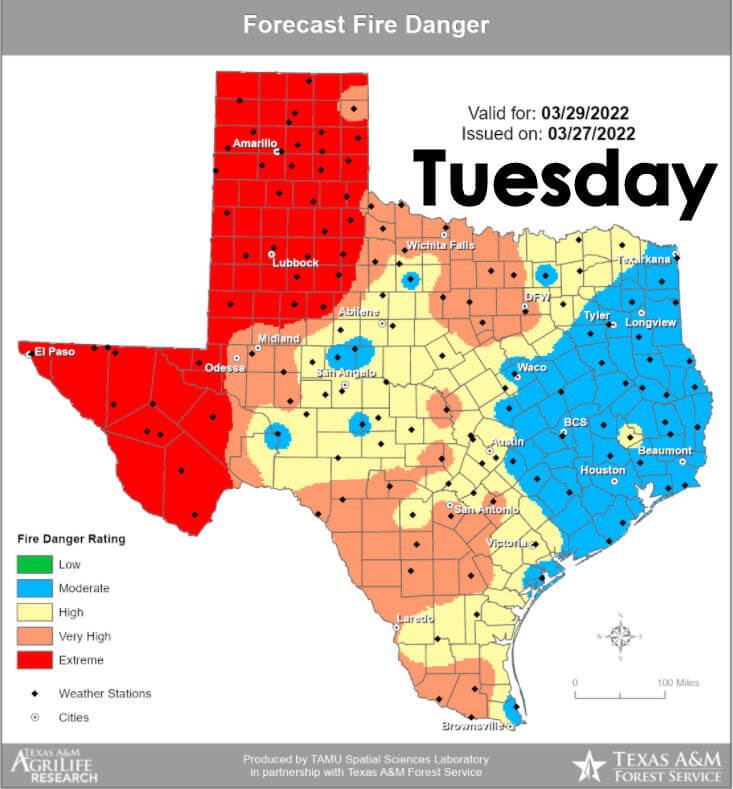
On Tuesday, a significant wildfire episode is possible across the western third of Texas. Drought-stressed fuels, wind gusts up to 60 miles per hour, and downright hot temperatures will promote explosive fire behavior and growth. Even further east, where humidity levels will be higher, windy conditions in drought-stressed fuels will promote faster-moving wildland fires. Tomorrow is the kind of day where we could see uncontrolled wildfires make 5-15 mile runs, especially where the highest winds coincide with the lowest humidity values. Tuesday, especially Tuesday night, will be very windy across most of Texas.
Thunderstorm Discussion
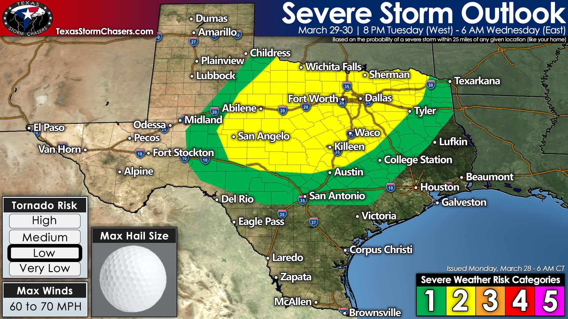
Severe weather outlooks issued by the Storm Prediction Center utilize a five-level risk scale. Each risk level is based on the probability of severe storms within twenty-five miles of any given point, such as your location. A level one risk is the lowest and means isolated/short-lived severe storms are possible. A level five risk is the highest, is quite rare, and indicates a significant tornado outbreak or derecho is likely. For tomorrow, we have a level two out of five risk encompassing Northwest Texas, the Big Country, the Concho Valley, Texoma, North Texas, and some of the Hill Country. Don’t get hung up on the exact line placements – since being in or near any risk level means you have the opportunity for stormy mischief.
Threats
East of the dryline, we’re expecting a line of showers and thunderstorms to begin developing around sunset – or a couple of hours later – tomorrow evening. A few initial storms may exhibit supercelluar characteristics, with large hail and localized damaging winds possible. A brief tornado can’t be ruled out.
A quick transition over to a squall line is expected. The squall line will move from west to east late tomorrow night and into the morning hours on Wednesday. Localized damaging straight-line winds, brief spin-up tornadoes, and pocket-change size hail will be possible with the strongest storms within the squall line. Some sections of the squall line may not even be all that strong.
Tomorrow’s storm mode will favor a squall line versus discrete storms, unlike last Monday. Even brief, weak tornadoes and damaging straight-line winds can be impactful. You certainly would feel that way if one came rolling down your street tomorrow night.
Timing
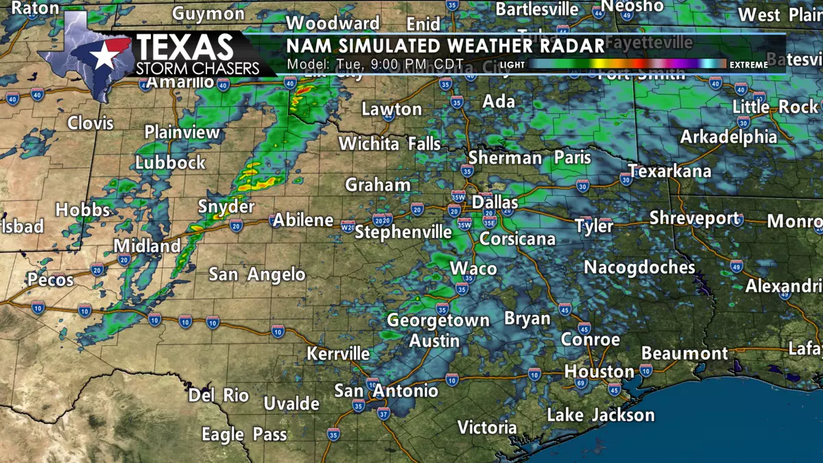
How far west storms initially develop is still questionable. Still, we think they’ll fire up from western Oklahoma south into Northwest Texas, the Big Country, into the Concho Valley between 8 PM and 10 PM Tuesday. Individual storms will move northeast, but the line as a whole will progress to the east at around 40 miles per hour.
Storms could be approaching Interstate 35 from Gainesville to Fort Worth and southwest into the Hill Country around 2 AM Wednesday. Arrival along Interstate 35 across Central Texas is likely to hold off until around 4 AM to 6 AM. Showers and thunderstorms will enter East Texas between 4 AM and 7 AM while pushing into Southeast Texas and the Coastal Plains after 6 AM. Between one-quarter and a half-inch of rain may fall from Northwest Texas south into the Concho Valley with tomorrow night’s storms.
Rain totals between one-quarter and one inch will be possible across Texoma, North Texas, Northeast Texas, and East Texas. We’ll be lucky to get more than sprinkles in the Permian Basin, Edwards Plateau, and South Texas. Rain chances will end from west to east on Wednesday as the line of storms moves into Arkansas and Louisiana.


0 Comments