
Damage surveys by the National Weather Service have confirmed three separate, long-lived tornadoes from Saturday’s event in East Texas. All three tornadoes were rated ‘strong’ based on the damage produced. Tornadoes are rated off damage, so it is possible the tornadoes may have been stronger while passing over uninhabited locations and/or Lake Murvaul.
The first tornado began at 6:04 PM southwest of Rusk and the last tornado in Texas lifted 121 minutes later northeast of Deadwood. Each tornado was down for around thirty-minutes with lengths ranging from 16 to 21 miles. The final Texas tornado, southeast/east of Carthage, became nearly one mile wide and resulted in our only fatality.
There is considerable damage along the parent supercell’s track, but we are fortunate that we were spared more violent/extreme tornado damage. We came close to having a large, destructive tornado moving into Carthage. We have another two months of the ‘spring’ tornado season to get through. Use this event as another reminder that it is vital you and your family have a severe weather safety plan in place. Have a way to receive weather warnings so you’re kept ‘weather aware’ regardless of the forecast. You can find severe weather safety information here.
Tornado #1 – Central Cherokee County
Rating: EF2
Estimated Peak Wind: 120 mph
Path Length /statute/: 20.67 miles
Path Width /maximum/: 500.0 yards
Fatalities: 0
Injuries: 0
Start Date: 03/27/2021
Start Time: 06:04 PM CDT
Start Location: 8 SSW Rusk / Cherokee County / TX
Start Lat/Lon: 31.689 / -95.2304
End Date: 03/27/2021
End Time: 06:38 PM CDT
End Location: 4 ESE Reklaw / Nacogdoches County / TX
End Lat/Lon: 31.835 / -94.9262

Damage survey track from National Weather Service in Shreveport (NWS SHV).
Summary from NWS Shreveport
The tornado originally touched down just southwest of Russell Cemetery off FM-23 south-southwest of the city of Rusk in Cherokee County. The tornado continued onward to cross US- 69 with intermittent damage along CR-1101. The tornado crossed FM-343 and intensified and widened significantly to approximately 500 yards.
Several hundred trees were snapped continuously along the 500-yard wide path along CR-1211 and CR-1209. The tornado then weakened and provided more intermittent damage before lifting in extreme NW Nacogdoches County northwest of the Sacul community.
Tornado #2 – Mount Enterprise, TX
Rating: EF2
Estimated Peak Wind: 115 mph
Path Length /statute/: 21.28 miles
Path Width /maximum/: 300.0 yards
Fatalities: 0
Injuries: 0
Start Date: 03/27/2021
Start Time: 06:59 PM CDT
Start Location: 1 W Mount Enterprise / Rusk County / TX
Start Lat/Lon: 31.9093 / -94.6933
End Date: 03/27/2021
End Time: 07:29 PM CDT
End Location: 3 NNW Gary City / Panola County / TX
End Lat/Lon: 32.0669 / -94.3878
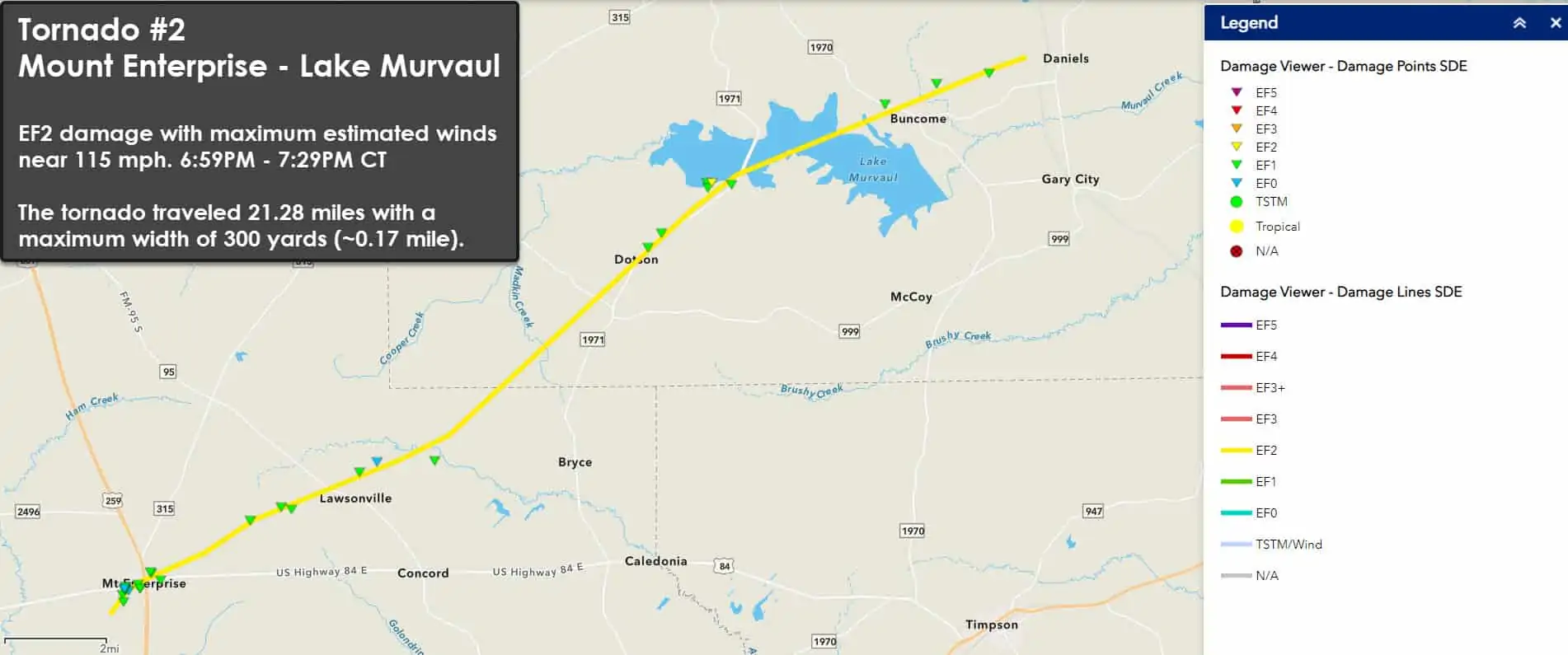
Damage survey track from National Weather Service in Shreveport (NWS SHV).
Summary from NWS Shreveport
The tornado touched downed about 1 mile southwest of Mount Enterprise, where it uprooted trees in an open field southwest of town. The tornado continued on to cause shingle damage to several single-family homes. One home had its roof mostly removed near the intersection of US-84 and W 5th St.
The tornado continued onward to damage a church steeple as it crossed US-84. The tornado continued to snap and uproot trees and produce shingle damage as it passed across the north side of Mount Enterprise. After moving out of Mount Enterprise, the tornado continued to uproot and snap trees until it reached several residences on the shore of Lake Murvaul. There, the tornado increased in intensity as it snapped or uprooted most trees and damaged the shingles on many homes.
The tornado crossed Lake Murvaul, and it weakened as it began to produce more sporadic damage. A preliminary analysis indicates that the tornado lifted after uprooting trees northeast of Lake Murvaul and northwest of Gary City. While the prelim analysis does not show a continuous track, data from aerial surveys conducted by partners may indicate that there was one continuous track to just south of Carthage.
Tornado #3 – Southeast and East of Carthage, TX
Rating: EF2
Estimated Peak Wind: 125 mph
Path Length /statute/: 16.68 miles
Path Width /maximum/: 1600.0 yards
Fatalities: 1
Injuries: 1
Start Date: 03/27/2021
Start Time: 07:38 PM CDT
Start Location: 4 SSE Carthage / Panola County / TX
Start Lat/Lon: 32.0982 / -94.3089
End Date: 03/27/2021
End Time: 08:05 PM CDT
End Location: 9 W Keachi / Panola County / LA
End Lat/Lon: 32.2012 / -94.0669

Damage survey track from National Weather Service in Shreveport (NWS SHV).
Summary from NWS Shreveport
The tornado touched down near US-59 south of Carthage, where it downed and uprooted approximately ten hardwood and softwood trees. The tornado intensified as it ran parallel to FM- 2517 and ripped the roof off a single-family home. The tornado continued to completely destroy 3 metal outbuildings and shift another single-family home off of its foundation. At this location along CR-405, the tornado tossed an antique vehicle 50 yards and wrapped sheet metal around approximately 10 trees.
The tornado continued to snap large softwood trees along CR- 407. The tornado crossed FM-699 and caused moderate roof damage to a brick home near the intersection of CR-407 and CR-408. A single-wide manufactured home utilizing a pan anchorage system was pulled free from the anchors, destroyed, and some of the debris was blown a couple of hundred yards into a field to the east.
The tornado widened considerably and produced a wide swath of snapped trees north and south of FM-2517, likely numbering well into the hundreds, especially in an area along CR-448. As the tornado crossed Hwy 31, a large outbuilding was destroyed, but portions of the wooden frame remained anchored by bolts to the foundation.
In this same area, a large pine tree was uprooted and fell onto a single-wide manufactured home killing one person and injuring another. The tornado continued northeast, snapping and uprooting trees as it traveled north of FM-2517. It crossed CR-470, CR-471, and finally lifted just east of CR-332.


0 Comments