
The freezing line has made it south to a line from Rocksprings to Boerne to Pflugerville to Giddings to Palestine to Gilmer to Avery. Spotty showers (producing sleet and freezing rain) are moving northeast across Central Texas, North Texas, and Northeast Texas. Additional heavier precipitation is developing back west from near Rocksprings to Kerrville. While not widespread, any sub-freezing location with one of these heavier showers (and even storms) move overhead can expect a quick coating of ice to develop. These showers have been responsible for several instances of rapidly deteriorating road conditions. The road impacts are hit or miss but can certainly cause headaches if you suddenly enter an area with those enhanced ice accumulations.
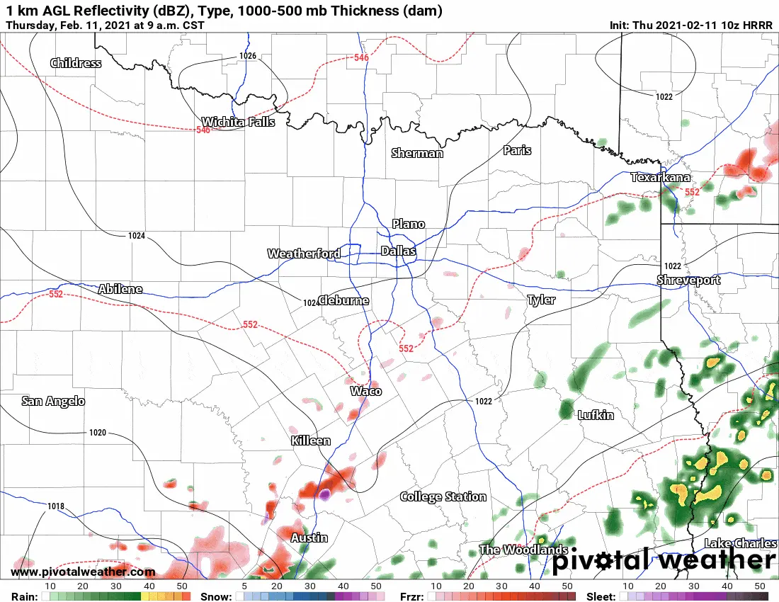
HRRR Weather Model: Simulated weather radar through the early evening today across North & Central Texas.
Some good news is we anticipate freezing drizzle to diminish in coverage across most of Texas by the afternoon hours. That should prevent new issues of icy bridges across the Panhandle, West Texas, Permian Basin, Big Country, and most of North Texas (including the D/FW Metroplex). At the same time, heavier precipitation is likely to continue through the afternoon across southern North Texas, the Hill Country, Central Texas, and the Brazos Valley. Hopefully, the freezing line will retreat north a bit this afternoon – keeping more substantial ice accumulations out of the Austin metro.
Freezing Rain Continues This Afternoon in Southern North Texas
However, there is an increasing concern of substantial ice accumulations (over one-quarter inch) this afternoon in southern North Texas and northern portions of Central Texas. Not only would heavier ice amounts cause more travel issues, but they could also result in tree damage and power outages. Another concern is that temperatures will likely have issues rising above freezing over the next couple of days. We’ve got a significant snowstorm coming in on Sunday and Monday that would weigh those trees down even more. Scroll down for more on the Sunday and Monday winter storm. Precipitation should end across most of Texas by late this evening. Still, it may take until the pre-dawn hours Friday in South Texas and the Rio Grande Valley. Little in the way of melting is expected, with temperatures tonight falling into the teens and twenties where accumulations exist.
The next few days will be cool to downright cold across Texas. Given the ongoing winter weather and a focus on Sunday and Monday’s system, I will leave the temperature discussion for another blog post. A reinforcing surge of arctic air will arrive on Sunday and result in a big-time temperature drop on Sunday, Sunday Night, and eventually for all of Texas on Monday. We’re not talking about cold air – we’re talking about the coldest airmass we’ve seen in several years.
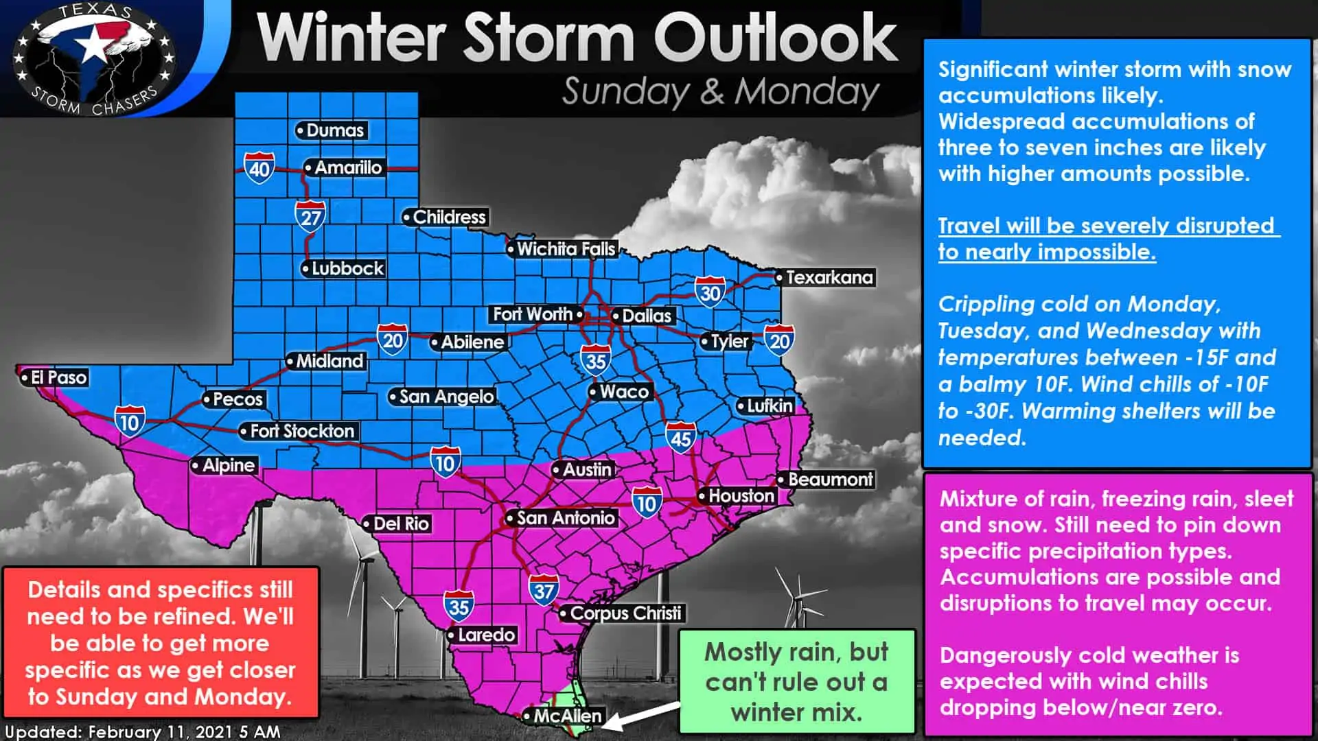
Widespread Winter Storm Potential (Sunday and Monday)
I have a feeling most of you are not here to know how cold we’re going to be, but how much white stuff might fall out of the sky. Alas, let’s dive into that hornet’s nest and see if we can’t help provide a few answers. Considering the upper-level storm system responsible for our upcoming winter mischief won’t arrive on the US West Coast (and the weather balloon network) until Friday night, we’re still going to see changes to the forecast.
Long-time readers know I don’t ‘hype’ events just to get likes or clicks. I try to share the information we know, explain a few uncertainties, and not share bad news. Remember that as you keep an eye on the forecast over the next several days.
Long-range weather models remain in unusually good agreement for Sunday and Monday. While deterministic weather models (GFS, ECMWF, Canadian, UK-Met) and their ensembles (the same model run dozens of times with slightly different initiation parameters) differ on exact totals, most show a winter storm moving across Texas on Sunday and Monday. Confidence is increasing for a significant winter storm resulting in high-impacts over a widespread area.
Snow is likely to be underway by Sunday afternoon (maybe Sunday morning) across the Texas Panhandle and West Texas. By Sunday Evening, snow, some of being heavy, could be falling across Texas’s western half. Widespread snow would then move east Sunday Night and on Monday. Significant snow accumulations (3 to 6 inches for now, but with higher amounts possible in future forecast updates) across Texas’s northern half with extremely dangerous to nearly impossible travel conditions. Gusty north winds and dry, powdered snow would result in blowing snow and snowdrifts. Precipitation-wise, this looks like nearly 100% coverage for Texas from start to end. That does not mean the entire state of Texas will see snow on Sunday and Monday.
However, assuming we do have our arctic airmass in place, a mix of freezing rain, sleet, and snow could fall as far south as Zapata to Raymondville in Deep South Texas. This may end up being the most widespread winter weather event Texas has seen in many years in that nearly the entire state could see some form of frozen precipitation on Sunday and/or Monday. Specifics on this will change, and we’re not even touching the whole ‘how much sleet’ or ‘how much ice’ may fall across the southern half of Texas. Accumulations of both precipitation types are possible and could result in their own travel nightmares in cities we don’t usually end up having winter weather in very often.
We need to get the storm system onto the West Coast to get weather balloon data on it. That process will not begin until Friday night, so we are still ‘guessing’ about some storm system aspects. This will be a case where the cold air should be in place before the winter storm begins, somewhat of a rarity in the southern United States.
While Sunday and Monday’s winter storm could be one we remember for years to come, I want to remind folks that changes to the forecast are still likely. As we get closer to the event, we’ll be able to narrow down specific precipitation types, timing, accumulation totals, and temperatures during and after the event. Winter Storm Watches will be issued by the National Weather Service once we’re within a few days of the winter storm’s onset.
Record-Breaking Cold During and After the Winter Storm
A brutal arctic airmass will be in place during the event. Even colder air will filter in as the winter storm departs late Monday and on Tuesday. The coldest airmass in decades will be in place Monday Night and Tuesday across Texas. Danger from the cold will be a real threat, and forecast temperatures may need to be lowered significantly in future forecasts due to a snowpack’s impacts. In areas where we have a snowpack by Tuesday morning – subtract five to ten degrees off the ‘low temperature forecast’ for Tuesday.
Yes, that would result in low temperatures near or below zero across the Panhandle, West Texas, Northwest Texas, Big Country, Concho Valley, and even in parts of North Texas. Single-digit lows may occur as far south as Interstate 10 in South and Southeast Texas. As for the wind chills? Ten to thirty degrees below zero is a good bet at times on Monday and Tuesday across the northern two-thirds of Texas. We could have a real problem with folks needing warming shelters if the winter storm on Sunday and Monday results in power outages or stranded travelers.
Temperatures may start a warming trend on Wednesday across the southern half of Texas. However, temperatures will be hard-pressed to rise above freezing across the northern half of Texas next week until any snowpack melts off. Speaking of which, we may have another chance of snow across Texas’s northern half on Wednesday into Thursday.


0 Comments