
A multi-faceted, multi-day severe thunderstorm and flooding event will follow an eclipse in Texas next week. The potential for all modes of severe weather is apparent beginning Monday afternoon and continuing through Wednesday – including Monday Night and Tuesday Night. With severe weather possible during the overnight hours, including a nocturnal tornado threat, we encourage folks to check back for weather updates through the weekend as we approach early next week.
Today through Monday will bring extreme wildfire danger to the Texas Panhandle, West Texas, Northwest Texas, Big Country, Concho Valley, Edwards Plateau, Permian Basin, Trans-Pecos, Big Bend, and the Borderland (El Paso). Low humidity, strong winds statewide, and warm temperatures will prime surface fuels for combustion. Winds will be strongest today, with some wind gusts of 55 MPH likely. A dryline will push east tomorrow, keeping the eastern half of Texas on the ‘moist’ side, while Sunday will feature much drier weather for the northwestern two-thirds of Texas. Even with slightly less wind, tomorrow will continue the trend of dangerous wildfire danger.
Monday’s Cloud Cover Forecast
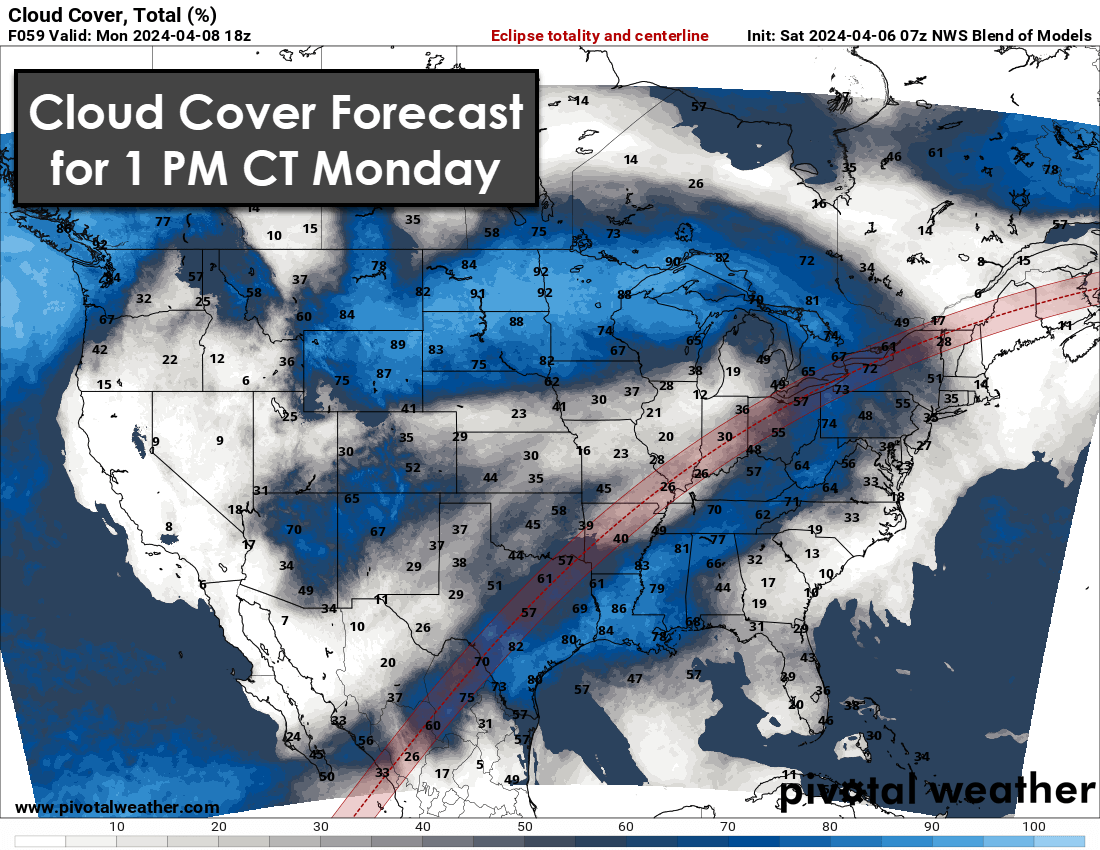
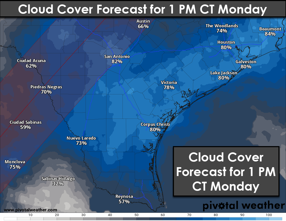
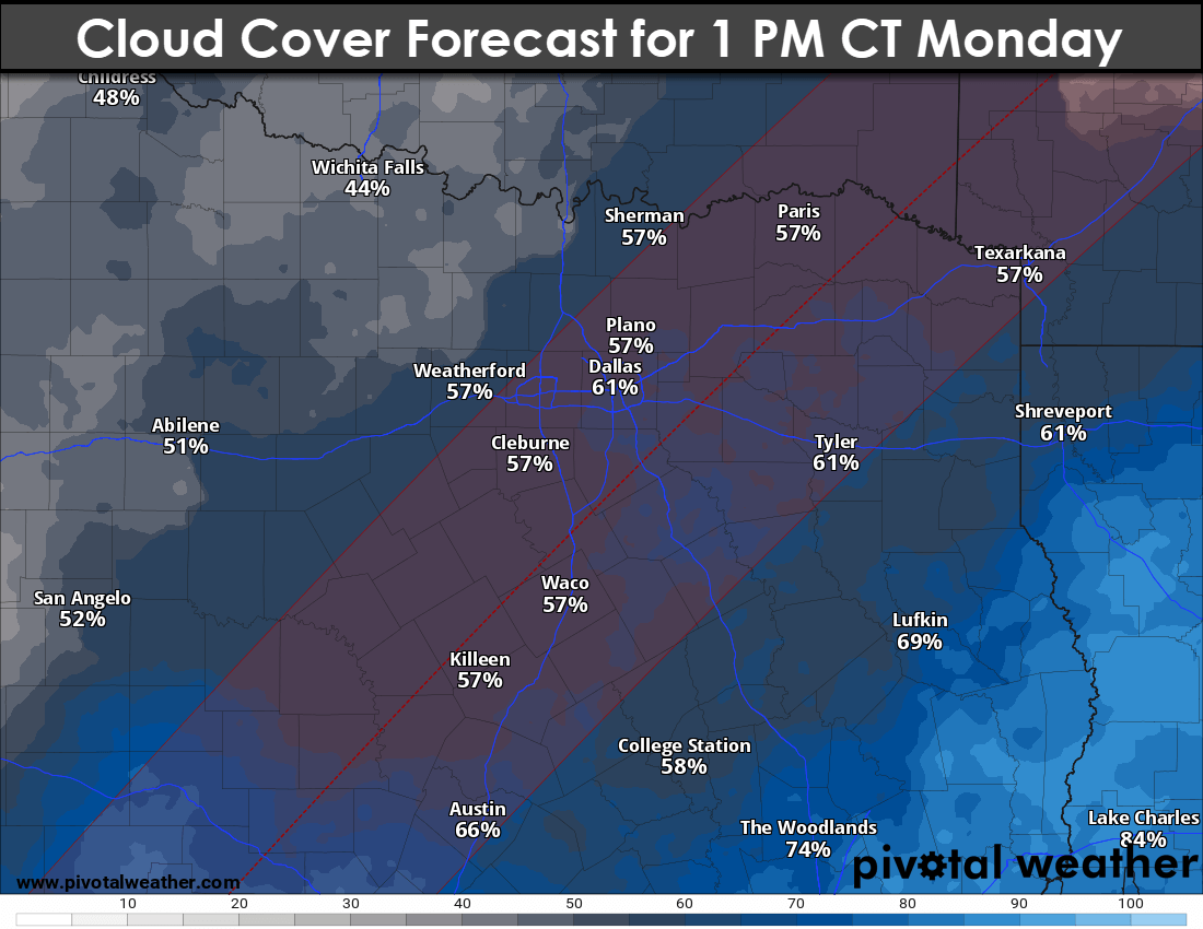
Be prepared for rapidly increasing cloud cover on Monday morning across most of Texas, including along the path of totality for the eclipse. Upper-level clouds are almost inevitable, while low-level clouds associated with a northward-moving warm front will likely hinder viewing for most locations. If some high-resolution weather model guidance is believed, parts of Northeast Texas may luck out with a few breaks in the clouds. That’ll be something we closely monitor with incoming data today. The best locations look like northern Arkansas, the bootheel of Missouri, southern Illinois, southern Indiana, and portions of Vermont, New Hampshire, and New England.
Multi-Day Severe Weather & Flooding Event Begins Monday Afternoon
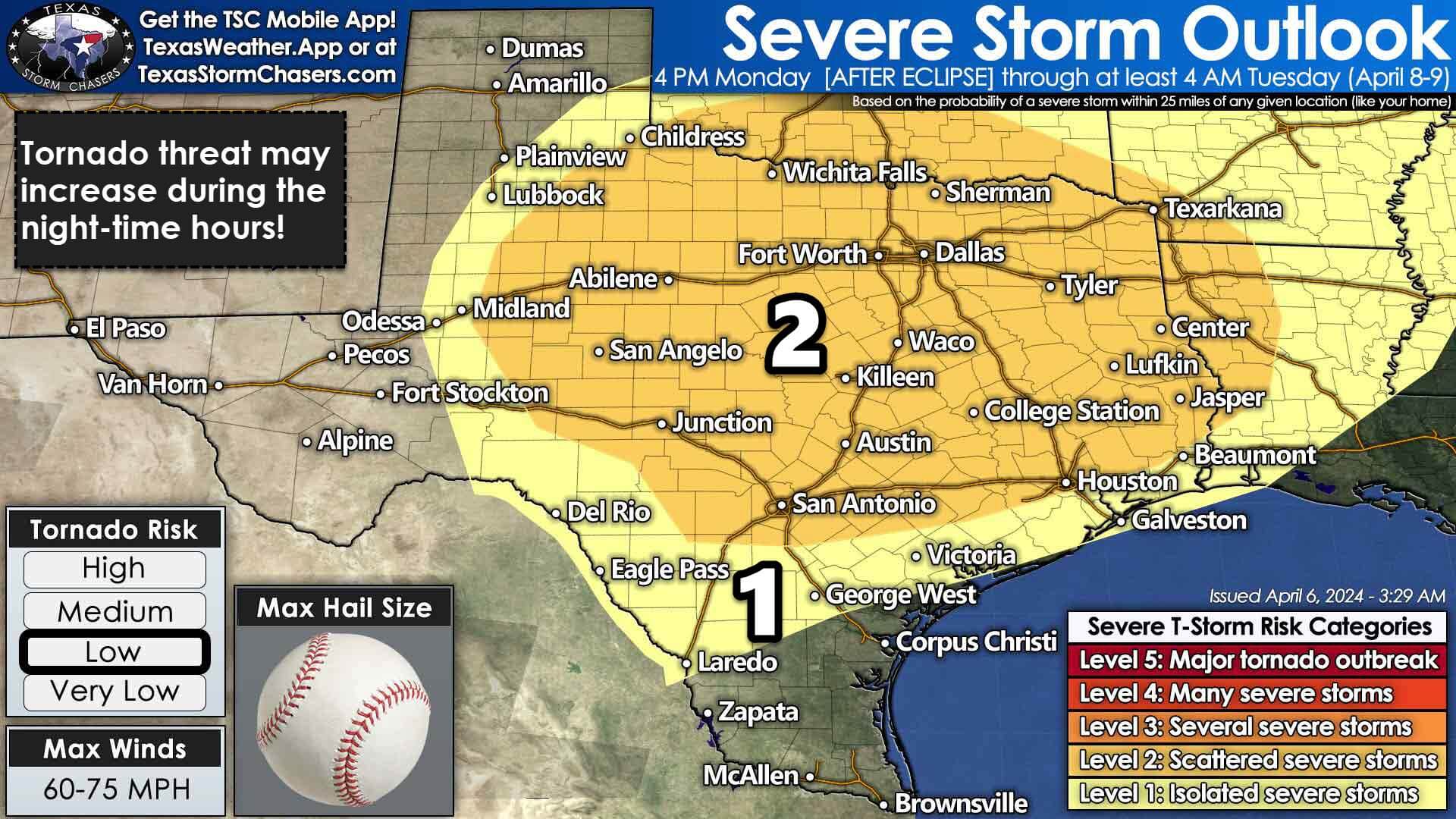
Shortly after the eclipse on Monday afternoon, our focus will shift to the possibility of severe thunderstorms. Monday, Tuesday, and Wednesday – including the overnight hours – feature scattered to numerous thunderstorm chances across the eastern half of Texas. Some storms are likely to be severe, with the risk of large hail, damaging wind gusts, and perhaps tornadoes. Heavy rainfall will increase the potential for flooding and high-water impacts in eastern North Texas, the Ark-La-Tex, Northeast Texas, and East Texas on Tuesday and Wednesday.
Specific timing for severe thunderstorms, threat levels, and hazards will be refined as we get closer to early next week. I want to emphasize the concern that we could have scattered severe thunderstorms underway by late Monday afternoon, Monday evening, and through the night-time hours into Tuesday morning across Northwest Texas, Big Country, Concho Valley, Hill Country, Texoma, North Texas, Central Texas, South-Central Texas, the Brazos Valley, East Texas, Northeast Texas, the Ark-La-Tex, and Southern Oklahoma. Please keep that in mind for any post-eclipse travel plans.
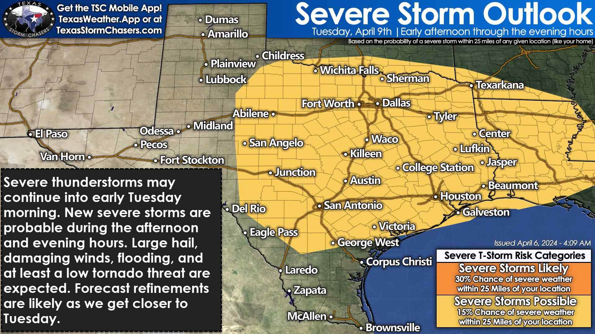
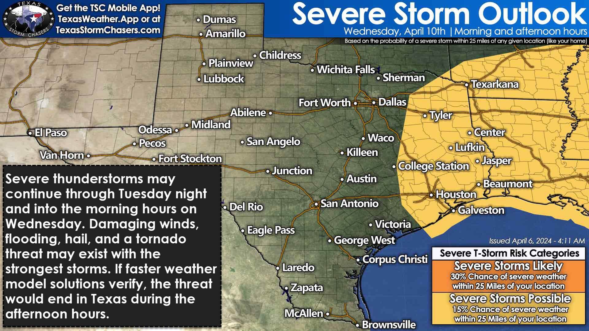
We’ll likely be busy on Monday, Tuesday, and Wednesday. Severe thunderstorms and heavy rain chances will continue in the regions mentioned above and expand into the Coastal Plains and Southeast Texas. The severe thunderstorm threat will increase again Tuesday afternoon through Wednesday morning across the eastern two-thirds of Texas.
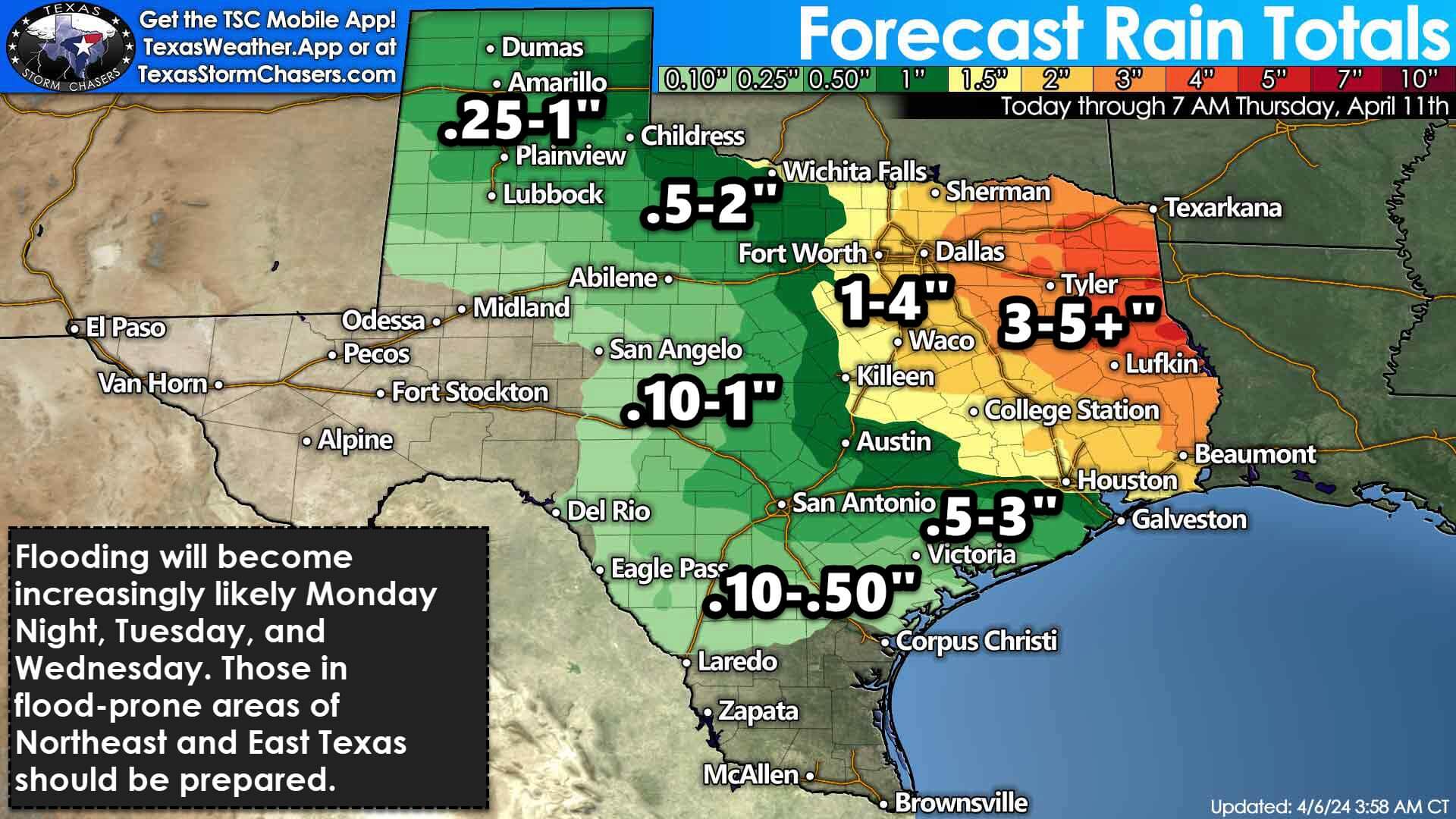
The multi-day part of this event comes thanks to a very slow-moving upper-level storm system. That’ll keep us in a favorable environment for severe storms and heavy rainfall. I’d encourage Y’all to check back for forecast updates as we head into the weekend and early next week.
Useful Links
Our FREE & AWESOME weather app for radar/alerts/more: https://texasweather.app/
Interactive Weather Radar on our website: https://texasstormchasers.com/radar
The 24/7 Texas weather tracker & music: https://www.youtube.com/watch?v=lNZuPEWS5AI&t=0s
Storm chaser videos: https://www.youtube.com/texasstormchasers
Facebook: https://www.facebook.com/TxStormChasers
TikTok: https://www.tiktok.com/@texasstormchasers
X (Twitter): https://twitter.com/TxStormChasers

0 Comments