
A multi-day severe storm event will follow an eclipse in Texas next week. Somehow, I figured Mother Nature wouldn’t let us get away with friendly, calm weather. Outside of limited thunderstorm chances Saturday night in Northeast Texas, we won’t have significant precipitation concerns until Monday afternoon.
High Wildfire Danger for Western Texas This Weekend
The Texas A&M Forest Service is forecasting very high to extreme wildfire danger today, Saturday, and Sunday for the Texas Panhandle, West Texas, Permian Basin, Big Bend, Southwest Texas, and the Borderland in Far West Texas. On Sunday, the risk may spread east to include Northwest Texas, the Big Country, and the Concho Valley. Low humidity, strong winds statewide, and warm temperatures will prime surface fuels for combustion – especially on Saturday and Sunday.

Winds will be strongest today and Saturday across Texas, with some wind gusts over 45 MPH likely. A dryline will push east tomorrow, keeping the eastern half of Texas on the ‘moist’ side, while Sunday will feature much drier weather for the northwestern two-thirds of Texas. The return of dry weather will be short-lived. Warm weather is expected through the weekend.
Eclipse Weather for Texas
Be prepared for rapidly increasing cloud cover on Monday morning across most of Texas, including along the path of totality for the eclipse. Upper-level clouds are almost certain, while low-level clouds associated with a northward-moving warm front are likely to hinder viewing. To be honest, if you’re keen on seeing the eclipse, you might have to consider going out of state. The bootheel of Missouri, southern Indiana, and parts of New York, Vermont, and New England seem to offer the best chance of clearer skies.
From Eclipse to Severe Storms


Shortly after the eclipse, Monday afternoon, our focus will shift to the possibility of severe thunderstorms. Monday, Tuesday, and Wednesday – including the overnight hours –feature scattered to numerous thunderstorm chances across the eastern half of Texas. Some storms are likely to be severe, with the risk of large hail, damaging wind gusts, and perhaps tornadoes. Heavy rainfall will increase the potential for flooding and high-water impacts in eastern North Texas, the Ark-La-Tex, Northeast Texas, and East Texas on Tuesday and Wednesday.
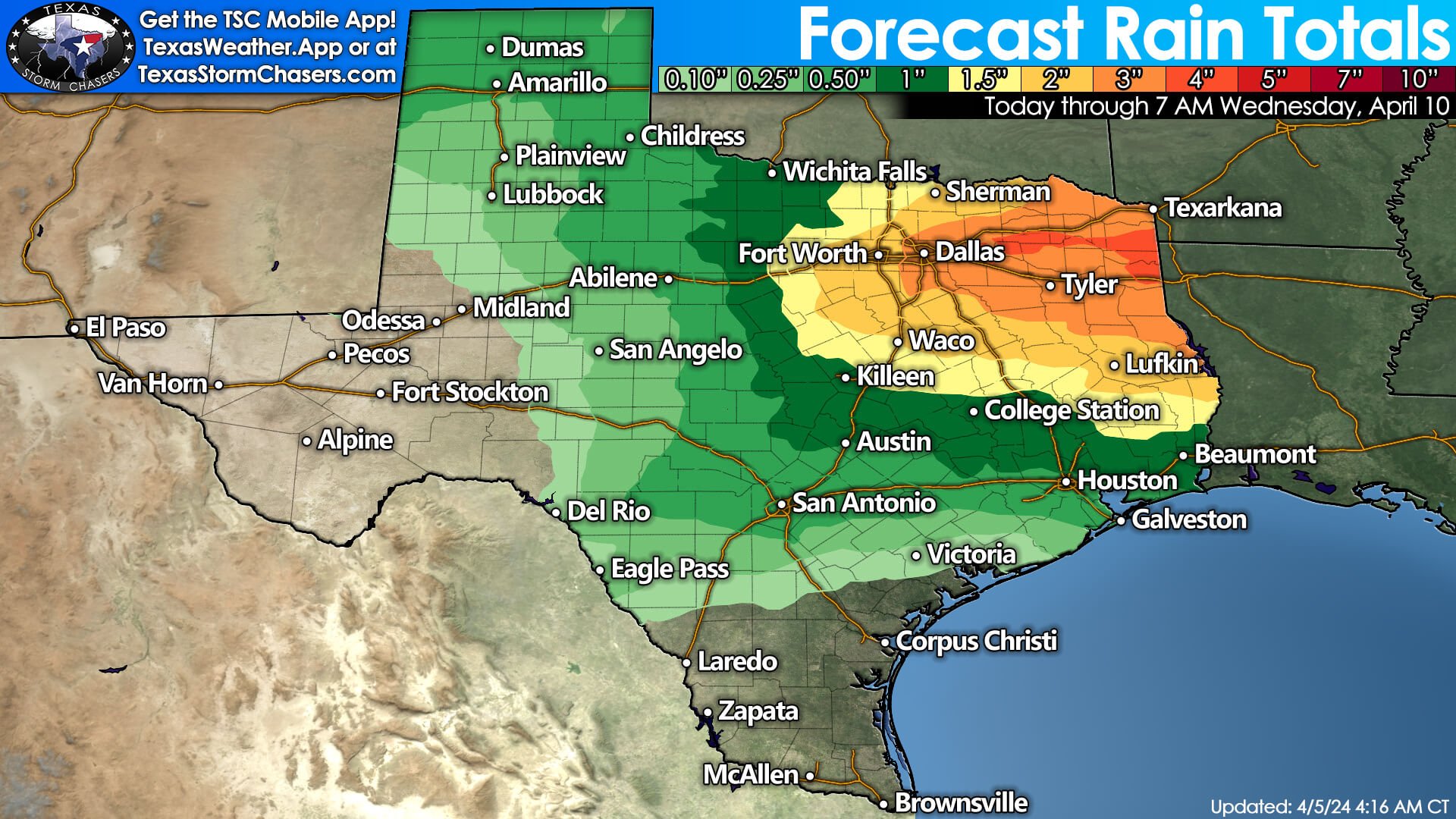
Specific timing for severe thunderstorms, threat levels, and hazards will be refined as we approach early next week. I want to emphasize the concern that we could have severe thunderstorms underway by late Monday afternoon, Monday evening, and through the night-time hours into Tuesday morning across the Big Country, Texoma, North Texas, and Northeast Texas—perhaps extending south toward Central Texas and East Texas. Please keep that in mind for any post-eclipse travel plans.
Baldy-in-chiefisms & notes
We’ll likely be busy on Monday, Tuesday, and Wednesday – with severe storm chances spreading farther south and east into the Brazos Valley and Southeast Texas. The multi-day part of this event comes thanks to a very slow-moving upper-level storm system that’ll keep us in a favorable environment for severe storms and heavy rainfall. I’d encourage Y’all to check back for forecast updates as we head into the weekend and early next week. You can get your local weather forecast, including more specific timing on rain chances, interactive weather radars, live severe weather coverage, and more in the free Texas Storm Chasers mobile app. Click here to download or search for Texas Strom Chasers where you download apps for your device.
Helpful links
The 24/7 Texas weather tracker & music: https://www.youtube.com/watch?v=lNZuPEWS5AI&t=0s
Storm chaser videos: https://www.youtube.com/texasstormchasers
Facebook: https://www.facebook.com/TxStormChasers
TikTok: https://www.tiktok.com/@texasstormchasers
X (Twitter): https://twitter.com/TxStormChasers
0 Comments