Fog and mist are common across Texas this morning, along with southerly winds. The northward transport of moisture is occurring ahead of an upper-level storm system over southern California. We’ll see southerly winds continue through the day as the upper-level storm system draws closer. A strong capping inversion will prevent thunderstorm development through much of the day. We might see an isolated storm around sunset in Texoma and the Red River.
For the most part, our weather show will begin late this evening and continue into the pre-dawn hours on Monday. While there is a risk for stronger storms, which we will discuss in detail below, I want to emphasize that not everyone will be impacted by a more vigorous storm tonight. We’re not expecting an outbreak of tornadoes, a derecho, or softball size hail. Yet, if we have one brief tornado tonight and it happens to come down your street, that would be a big-time event for you. Severe weather is a year-round occurrence in Texas. It’s just a part of living in the southern United States. As earthquakes are in California and hurricanes are for the Gulf Coast.
Severe Weather Outlook
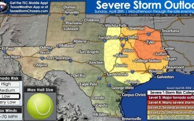
We talk a lot about risk levels and the ‘five-level risk scale’ from the Storm Prediction Center. The higher the risk, the higher the probability of a severe storm impacting your area. Sometimes we, and others, get too bogged down in the risk levels. It doesn’t matter if you’re in one risk level or another. It doesn’t matter precisely where lines are drawn on a map or the risk names’ phrasing.
If you’re in or near any risk zone – that’s a ‘heads up’ that you should monitor the weather for the ‘outlook period.’ For the outlook shared below, the risk period is this evening through the pre-dawn hours on Monday. Tonight’s weather-maker will be a nocturnal one consisting of thunderstorm chances increasing well after sunset and continuing through the night.
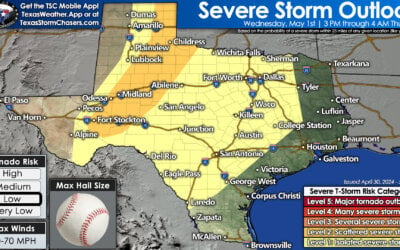
A level two out of five risk includes much of North Texas, including the D/FW Metroplex northeastward into Southeastern Oklahoma. A level one out of five risk consists of the Big Country, Northwest Texas, and a sliver of East Texas around Longview. Any risk level means there is the chance for strong to severe thunderstorms late tonight.
The exact placement of the risk zones will probably change somewhat as updates are issued throughout the day. Suppose upper-level lift ends up being more robust than anticipated. In that case, the risk for stronger storms might increase south of Interstate 20 in North Texas. Likewise, if the lift is weaker and we end up with a more robust capping inversion, we might not see many rowdy storms tonight at all.
Timing
Scattered thunderstorms are possible after 8 PM in North Texas ahead of a cold front. If storms were to develop between 8 PM-11PM in North Texas, they could produce large hail and quickly move northeast. The ‘main show’ looks to be with a southeastward moving cold front overnight. A line of showers and thunderstorms should be firing along the cold front by 10 PM in Northwest Texas.
Storms will increase in coverage with southward extent along the cold front as it moves east into the Big Country and North Texas after midnight. Some storms may be strong to severe with large hail and localized damaging wind gusts. A brief tornado cannot be ruled out, especially as storms approach Interstate 35 (D/FW Metroplex to Red River) and continue into Northeast Texas early Monday.
There is uncertainty on the strength of the storms early Monday as they move east of Interstate 35. Some weather models show an intense squall line – while others offer a thin line of showers and storms. Regardless, any stronger storm early Monday morning in Northeast Texas could produce hail and gusty winds. If we end up with a more potent line of storms, those could produce damaging straight-line winds, large hail, and isolated tornadoes. The cold front and associated precipitation should be moving into the Arklatex and East Texas by sunrise on Monday.
Nerdy discussion & possible alternative scenarios
Tonight’s main thunderstorm chances will be thanks to a southeastward moving cold front. Upper-level dynamics, in the form of lift and wind shear, are forecast to be strong. A limiting factor for a more significant severe weather threat is a strong capping inversion and the most substantial lift passing north of Texas.
As the simulated weather model image above shows, we could see a few semi-discrete thunderstorms rooted above the cap in North Texas by 10 PM this evening with a line of storms firing up along the cold front in Northwest Texas. Those semi-discrete storms could produce large hail if they’re able to develop. Storms along the cold front would generally be linear (a squall line). The strongest storms within the squall line (not all the storms) could produce large hail and localized damaging wind gusts.
You might notice I used the words ‘rooted above the cap’ to describe some of the thunderstorms. Those thunderstorms are considered ‘elevated’. The term ‘elevated thunderstorm’ means they developed above the capping inversion. They’re feeding off instability and wind shear in the mid-levels of the atmosphere. Still, They don’t have access to low-level wind shear or low-level instability just above the earth’s surface. Elevated thunderstorms can still be strong to severe with a risk of hail.
However, it is much more difficult for them to produce severe-caliper winds (58+ MPH) and pose little risk of tornadoes. We’re still uncertain if storms tonight will remain completely elevated or if we might see some become surface-based. The term ‘surface-based’ means storms can access low-level wind shear and the instability just above the surface. Those are the ones we’d be concerned about producing damaging straight-line winds and potentially a few tornadoes.
A warm front should be located near the Red River tonight in Texoma and Northeast Texas. As storms approach the warm front, they might be able to become surface-based briefly. An isolated tornado or two and damaging straight-line winds would be possible if any intense storm interacted with the warm front tonight. Suppose we have more lift than expected or another ingredient was ‘off.’ In that case, more storms could become surface-based; we’d have a higher risk for a few tornadoes and damaging straight-line winds in North Texas tonight. That isn’t the forecast this morning, but one possible scenario (even if it isn’t the preferred one with this forecast.) You can bet your bottom dollar we’ll be watching more intently than a kid waiting to get a shot in the doctor’s office.
If needed, I’ll also be providing live severe weather coverage on all of our social media channels late tonight. If you’re using our mobile app, you’ll be able to watch by clicking the ‘live’ button on the bottom menu bar (the button will be added later today).


0 Comments