
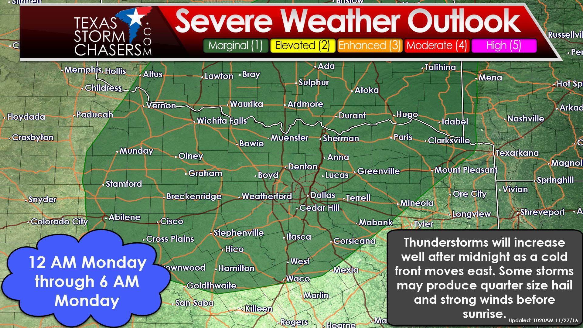
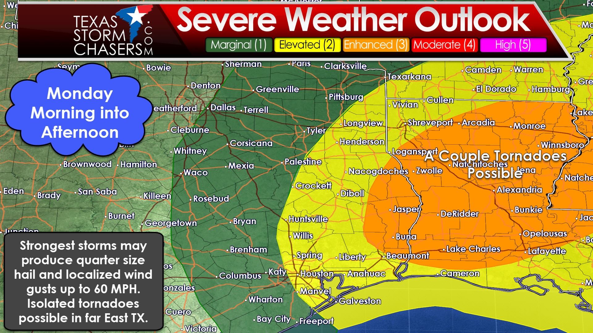
Severe Weather Outlook for Monday (does not include late tonight’s potential in North Texas)
Gusty winds will continue into the night as a low pressure in Kansas moves northeast while intensifying. That low pressure is allowing strong south winds, both at the surface and even stronger above the ground, to bring surface dewpoint values in the middle 60s north into East Texas. Moisture transport will continue into the night. A cool front (more of a wind shift/dryline honestly since it has little cool air) will move east late tonight and on Monday. Conditions west of the front will be dry with gusty west winds tonight and Monday. East of the front south winds will continue with overcast skies. Fire weather concerns will be present on Monday in the western half of Texas. Meanwhile thunderstorm chances will rapidly increase late tonight and in the predawn hours Monday across North Texas. This is due to a very strong low level jet, or strong winds over 60 MPH around 4,000 feet plus the cool front entering the area. Some storms may become strong to marginally severe with hail up to the size of quarters and localized wind gusts up to 50-60 MPH. Wind shear values will be extreme tonight and Monday, but they may actually be too strong. Sometimes with such extreme wind shear updrafts get torn apart before they can become too organized. The atmosphere won’t be overly unstable either, but we will have some instability in place. Regardless some folks are going to get woken up late tonight by some boomers. I do believe we are going to see some hail reports tonight, although I doubt we’ll see any larger than the size of a quarter. Some wind gusts up to 50-60 MPH are likely since winds just a few thousand feet above the ground are going to be screaming.
21Z HRRR Model – Simulated Radar Forecast through mid-morning Monday
By sunrise Monday we should have scattered thunderstorms underway near a cool front in North Texas plus more activity moving east/northeast in East Texas. Some of these storms may be strong to marginally severe with quarter size hail and wind gusts up to 60 MPH. As mentioned above wind shear values will be extreme, but the atmosphere won’t be overly unstable. Scenarios like this sometimes result in no severe weather due to thunderstorms getting sheared apart. Other times we can see line segments organize with an enhanced threat for damaging winds. Last week’s storm setup was the former where storms were unable to become severe. A line of storms will race east across Northeast Texas, East Texas, and parts of Southeast Texas during the morning and early afternoon hours Monday. A stronger cap will limit storm coverage/intensity from the Houston metro and points south/southwest. We will need to watch for any discrete storms that try and become supercellular in far East Texas tomorrow as they would have the potential to produce a tornado. The line of storms may have segments that produce wind gusts up to 60 MPH. The higher threat for severe weather and a couple of tornadoes will be on the Texas/Louisiana border and into central Louisiana tomorrow afternoon.
Precipitation chances will come to an end by late Monday afternoon as the cool front moves into Louisiana. Winds will be gusty out of the west behind the front and temperatures won’t actually be all that much cooler. Shower chances return to parts of Texas by Tuesday and a pretty good looking storm system will arrive by the weekend along with a significant temperature drop. Next weekend’s storm system may bring us a winter weather event to the Texas Panhandle and West Texas, although details will undoubtedly change ten times between now and than.


0 Comments