
The Storm Prediction Center has issued a short-term discussion update for Tornado Watch #120. They expect the threat for a few supercelluar thunderstorms to continue for the next several hours. The strongest storms may produce hail larger than the size of a baseball and localized wind gusts over 70 MPH.
Low-level wind shear is expected to increase after 7 PM – with an attendant uptick in tornado potential. A few tornadoes are possible this evening with the most intense storms. Those in Uvalde, Hondo, and the western San Antonio metro should keep a close eye on the storms as they move east. We’ll also watch for any new storms that develop in Northern Mexico that may move into Texas.
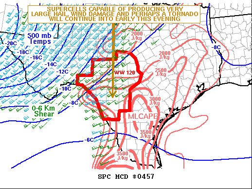
Summary: A severe threat will continue through early this evening across parts of southwest Texas. Very large hail, wind damage, and a tornado or two will be possible.
Meteorological discussion: The latest radar imagery out of Del Rio shows a cluster of severe storms located just southeast of Del Rio extending westward into far northern Mexico. The storms will continue to move eastward along a corridor of moderate instability over the next few hours. The RAP is showing MLCAPE in the 2500 to 3000 J/kg range from near Del Rio extending eastward into the southern Texas Hill Country.
The RAP suggests that 700-500 mb lapse rates are near 7.0 C/km. This combined 0-6 km shear in the 50 to 60 kt range, evident on the WSR-88D VWP, will be favorable for supercells with large hail. Hailstones of greater than 2 inches in diameter will be possible with the stronger updrafts. As low-level flow strengthens early this evening, a tornado threat is expected to develop. Wind damage can also be expected along the leading edge or within the stronger downdrafts.


0 Comments