
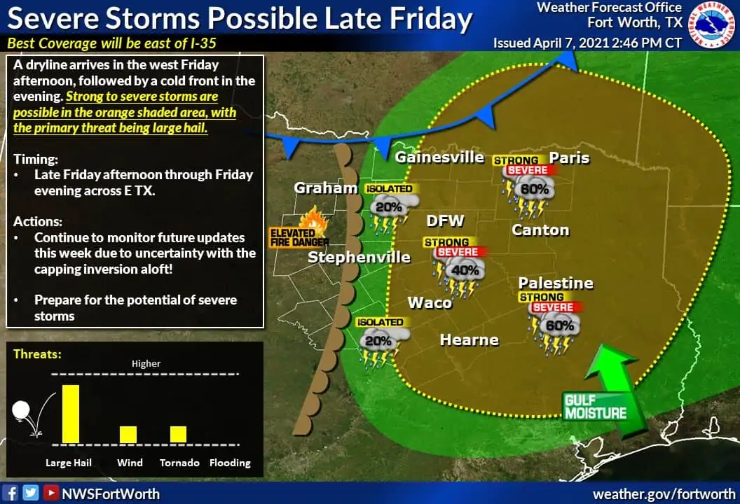
After an eventful end to March in the severe weather department, we’ve enjoyed a ‘break’ for the first week of April. Like most things, nothing lasts forever, and the dryline is poised to try and make some hailers on Friday. The dryline marks the sharp change from a moisture-rich air mass (east) to a very dry, and usually toasty air mass (west). During the late afternoon hours, the battle of the cap begins. Many days the cap will be too strong to overcome, and it is a sunny day. Some days though, the cap becomes weak enough for an updraft to punch through and take flight. Or, in our case, soar upwards to 55,000 feet and start throwing obnoxiously large hail around. Tomorrow looks like it’ll be a day where enough lift will be present to punch through the cap and ignite severe storms.
I know the severe weather outlook graphics tend to garner attention. Let me be clear by saying most folks are not going to see a thunderstorm tomorrow. We’ll probably be dealing with a discrete thunderstorm mode in North Texas with a few supercells. I say that since, by comparison, squall lines or larger thunderstorm complexes tend to impact more areas. However, any storm that gets going tomorrow afternoon and tomorrow evening will have a good chance of being rowdy. Few in number, but high-impact thunderstorms are the name of the spring dryline game (for most days).
Tomorrow’s Severe Weather Outlook
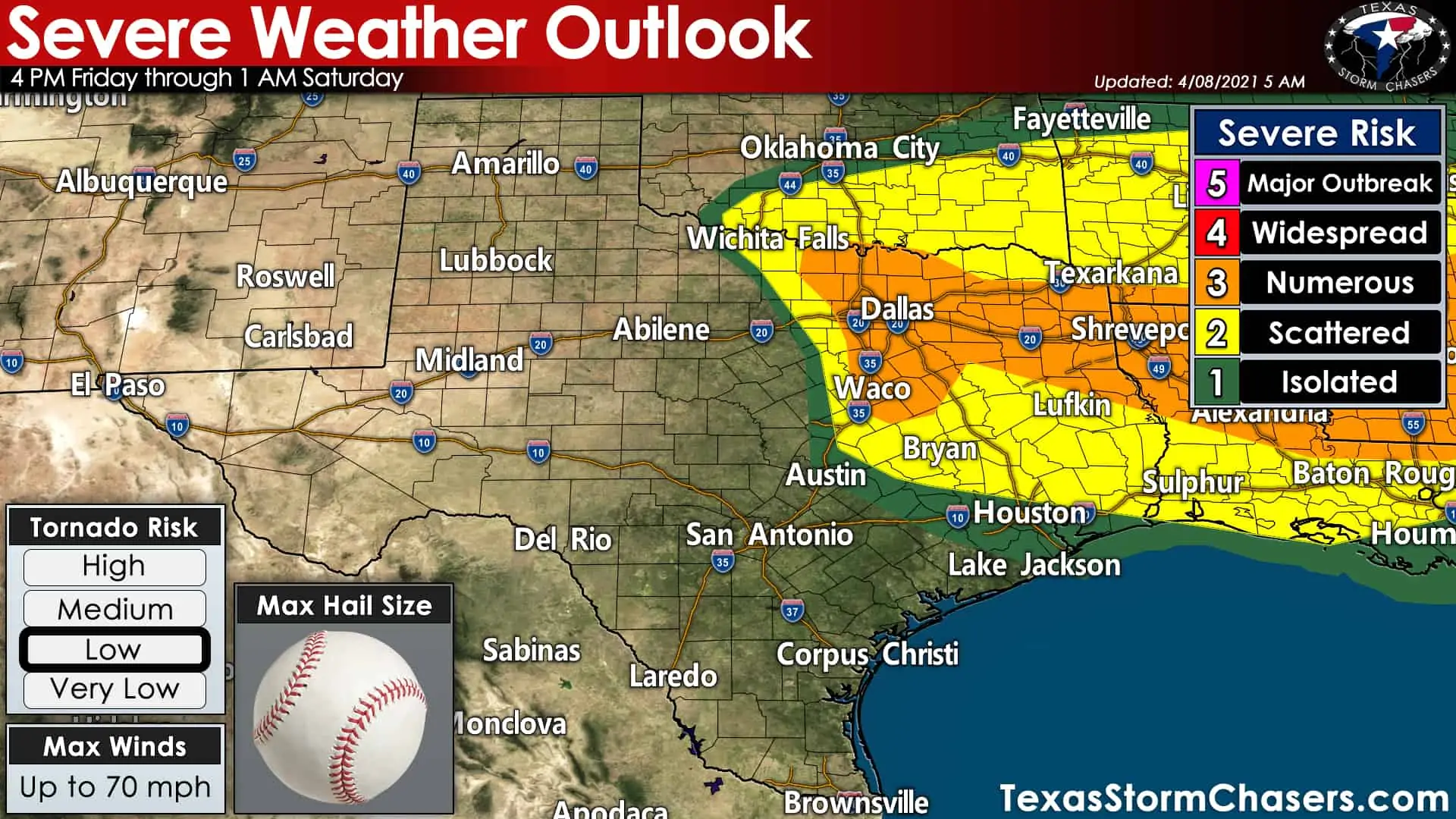
The dryline looks to set up shop around Highway 281 from Wichita Falls to Mineral Wells, south/southeastward toward Fort Hood/Killeen, by late Friday afternoon. While the dryline will extend further south, the cap (or lid that prevents thunderstorms) will also be stronger with a southward extent. Scattered severe thunderstorms are possible after 4-5 PM Friday across North Texas and in the Brazos Valley. Our friends at the Storm Prediction Center have highlighted a level one through level three risk. Severe weather threats are nearly identical in all of the risk zones. The higher a risk level – the higher the probability severe storms occur in your area. There are two areas of potential development we’re watching for tomorrow.
Development Zone #1
Isolated to scattered storms firing on the dryline near or up to 40 miles west of Interstate 35/35W in North Texas. This process is not likely to occur before 4 PM but may take until near 7 PM. We may only see a few storms, but once they bust through the cap, they’ll rapidly intensify and become severe. A very unstable airmass is expected to support very large, destructive hail potential (baseball size or larger) if storms get going. The tornado threat is low but may ramp up a bit after 7 PM with any intense supercells in progress. We do note these storms may be within the D/FW Metroplex, so we encourage folks to have a way to receive weather warnings tomorrow afternoon and tomorrow evening. As I said, this looks to be a limited number of storms, but those that get going will likely be severe.
Development Zone #2
Scattered thunderstorms may develop Friday afternoon and Friday evening in the Brazos Valley, East Texas, and Southeast Texas. Known as open warm-sector development, there may be enough lift from an upper-level storm system to weaken the cap across the aforementioned regions. There would not be a set ‘firing mechanism per se, but we could see cellular storm modes. Low-level wind shear will be stronger in these regions than farther west in North Texas, at least during the afternoon/early evening hours. Large hail, localized damaging wind gusts, and a few tornadoes would be possible. We’ll see what this morning’s weather model data shows and hopefully get a bit more specific.
Will the cap break?
The strength of the upper-level lift and the cap’s strength will place a big role in tomorrow’s severe weather threat. Frankly, it’s conditional on there actually being storms. Confidence in storm development has increased since yesterday, but there is still some question. Tomorrow may be a ‘blue sky bust’ where the cap holds, but that chance is decreasing. Remember: Tomorrow looks to be a day where there may not be many storms, but any storms that get going will be in a very ripe airmass to produce severe weather. If only one storm gets going tomorrow and ends up dropping softball size hail or a tornado in your town, it’s a huge impact event for you.
Storm Speed and Direction
Both zones would have storm motions off to the east/northeast. Any storms deviating to the right of the mean flow will likely move almost due east around 20-25 MPH. Any ‘left splits’ will move quickly north/northeast closer to 40-45 MPH. Most activity will move off to the northeast at about 30-35 MPH. As the dryline and eventually cool front move east Friday evening, we’ll see the risk of storms end from west to east. I’m hopeful we’ll have our last storms dissipating or moving east of Texas by 1-2 AM on Saturday. We may see some upscale growth into a thunderstorm cluster Friday evening in Northeast/East Texas with damaging winds.
Helpful Links and Severe Weather Safety
It is April in Texas. Storms are a typical part of life around the southern United States during the spring. Consider this a good time to brush up on what you and your family will do if severe weather approaches your location. We’ve got a page full of severe weather safety tips and ‘how to build a plan’ by clicking here.
The Storm Prediction Center will release an updated severe weather outlook for tomorrow around 12:30 PM today. You can view the latest severe weather outlooks for Texas by clicking here.
Finally, if you haven’t downloaded the free Texas Storm Chasers app, you’re missing out! You could have received this forecast straight on your phone.


0 Comments