
Tuesday afternoon brought isolated thunderstorms to portions of Texas. Some storms ended up producing pocket-change size hail and frequent lightning. Of interest, a weak shower produced a landspout tornado just northeast of Waxahachie in North Texas shortly before 5 PM. This occurred as the shower interacted with a boundary. That boundary allowed for enhanced low-level stretching and a quick landspout. Unlike superceulluar tornadoes, land spouts can typically be described as an in-land waterspout in their appearance. They’re usually weak, but sometimes they can be more substantial. They’re more common in the Panhandle and West Texas in late spring.
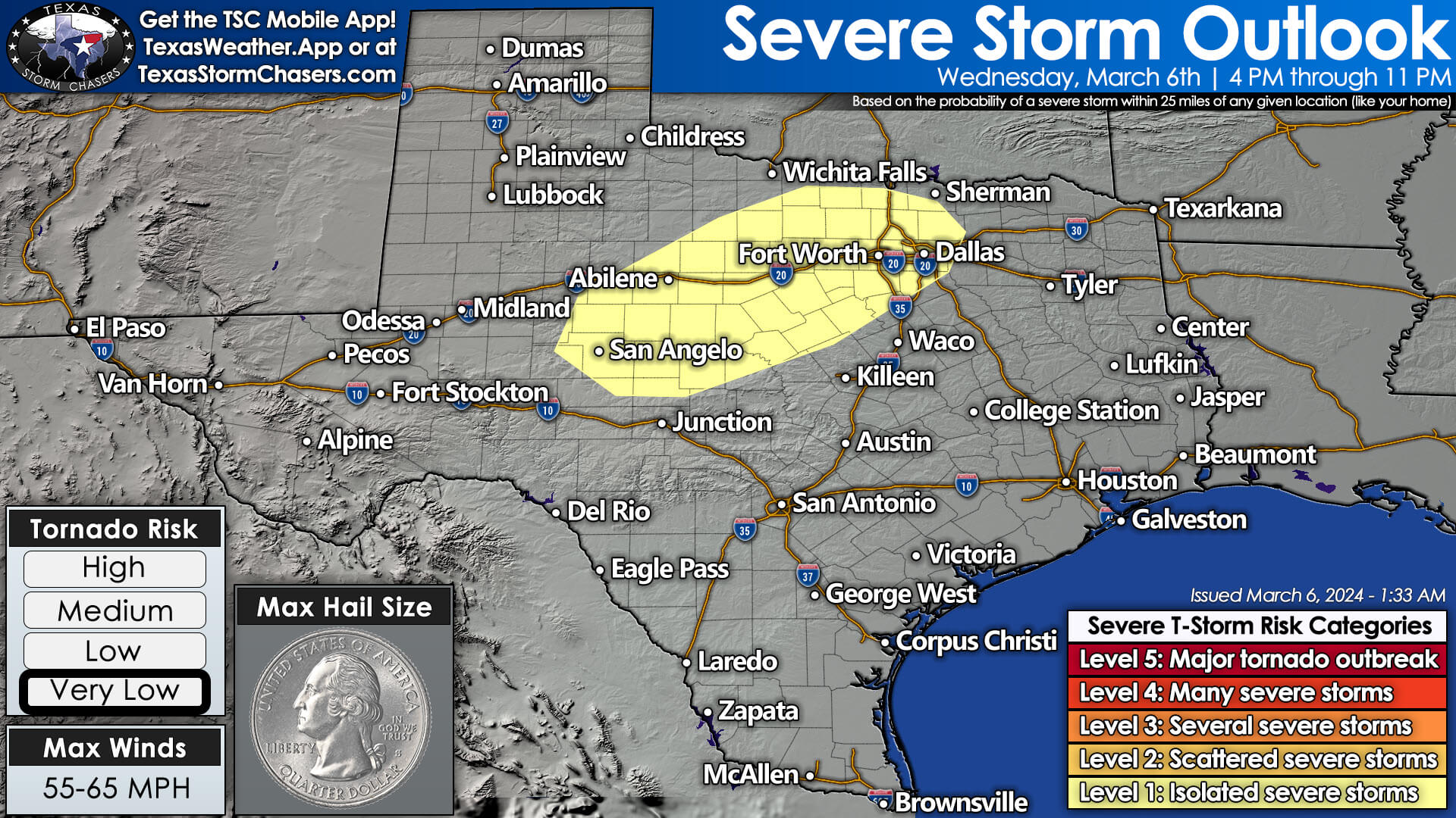
For today, we’re expecting another isolated threat of severe thunderstorms. After 3 PM, isolated thunderstorms may begin forming in the Big Country and Concho Valley. These storms will slowly move eastward. Stronger storms may produce pocket-change size hail and gusty winds. Thunderstorms will increase in coverage late this evening into Thursday morning from the Permian Basin eastward into the Big Country, Northwest Texas, Texoma, North Texas, and the Ark-La-Tex. Some storms may initially produce hail, but the severe thunderstorm threat should remain isolated. Some rainfall may continue into late Thursday morning across North Texas, Texoma, and the Ark-La-Tex.
Thursday’s Severe Storm Threat
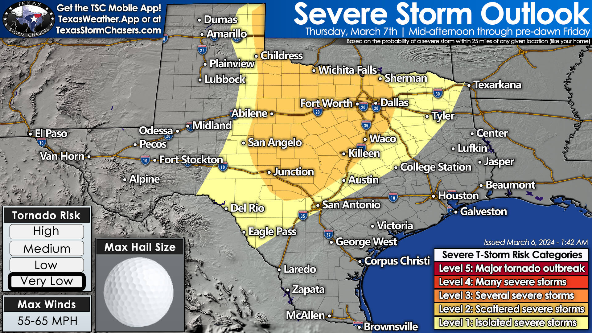
By mid-afternoon Thursday, another round of scattered thunderstorms are expected to develop east a dryline from the Edwards Plateau and Concho Valley north into the Big Country, Northwest Texas, into the eastern Texas Panhandle. Some storms may become superceulluar with a threat of large hail, localized damaging wind gusts, and a tornado. Several factors limit the tornado threat, but we can’t rule out one – especially in Northwest Texas and Southwestern Oklahoma.
We’ll monitor data to narrow down that corridor further in upcoming updates. Otherwise, we’ll likely see additional scattered thunderstorms continue developing late Thursday and into Friday morning across the Big Country, Texoma, North Texas, and the Ark-La-Tex. Some storms may remain strong with a threat of hail and gusty winds.
If storms can organize into an eastward-moving cluster, we may see higher rainfall coverage for Northeast Texas and East Texas on Friday morning. Some chance for new storms will exist across the southeastern half of Texas on Friday as a cold front arrives. The eventual chance for new storms will depend on how worked over the atmosphere is after the preceding two days.
Friday Texas Panhandle Snow?
Back in the Texas Panhandle, we may see an area of rain or snow move across the region Friday morning into Friday afternoon. This precipitation would be on the back side of a low-pressure surface. Temperatures aloft and at the surface may become cold enough to support snow. There is the potential for minor snow accumulations, but we’ll need to get within 36-48 hours to nitpick the potential for corridors of more impressive snow totals (2+ inches). Given the preceding warm weather and soil temperatures, we anticipate it will be similar to last week’s snow. Still, moisture is moisture – whether it falls as rain or snow.
The threat of wildfires will remain moderate to high across the western half of Texas through the remainder of the work week. That is lower than last week’s very high to extreme danger. We’ll be cooler this weekend across most of Texas, thanks to Friday’s cold front. The weekend is looking mostly dry.
My FREE & AWESOME weather app for radar/alerts/more: https://texasweather.app/
0 Comments